The week ahead: Tropical moisture returns, then we turn hot
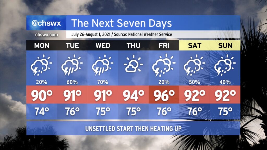
After a very rare weekend of relatively low humidity (for late July, anyway) we’ll see dewpoints return to the low to mid-70s as tropical moisture builds back into the area. Monday will feature isolated showers and thunderstorms primarily driven by the seabreeze, but as we get into Tuesday and Wednesday, a low pressure system — labeled by the National Hurricane Center as Invest 90L with a 50% chance of tropical development — will be approaching the coastline as we get into mid-week. Regardless of what it ends up doing from a tropical standpoint, it will enhance our shower and thunderstorm chances Tuesday and Wednesday, particularly in the afternoons. Temperatures will top out in the low 90s each day.
As we get closer to the end of the week, the strong high pressure over the central US noses its way into the eastern US. This, in turn, will drive down rain chances and drive up temperatures. Temperatures should top out in the mid-90s Thursday and Friday.
Owing to just how “mild” this summer has actually been, the hottest it’s been this year is 94°, which we’ve reached three times (twice in May and last on June 15). If Friday’s forecast of 96° verifies, that will be the warmest we’ve been all year.
By the weekend, we could see an uptick again in showers and thunderstorms as the ridge backs off a little bit and we get underneath some northwest flow aloft. NWS noted in its afternoon discussion that this could open up the pathway for summer thunderstorm complexes — the technical term for which is “mesoscale convective system” — to roar through the area starting this weekend. Something to watch, but nothing we need to be overly concerned about right now.
Rare air for July
As you can imagine, we don’t often get this far into July without eclipsing 95° at the airport. We have only made it to July 25 without hitting 95° four other times since records began in 1938: 1957, 1961, 1965, and 1966. Only in 1957, 1965, and 1966 did we make it all the way through July 31 without hitting 95°. That doesn’t appear to be in the cards this year, but it certainly underscores just how difficult it is to not go over 95° in a Charleston summer!
Follow my Charleston Weather updates on Mastodon, Bluesky, Instagram, Facebook, or directly in a feed reader. Do you like what you see here? Please consider supporting my independent, hype-averse weather journalism and become a supporter on Patreon for a broader look at all things #chswx!