Heavy rain to start the week, but a nice shot of fall to end it
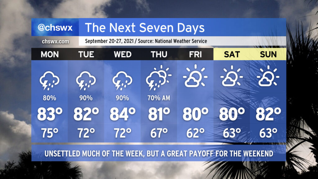
Let’s start with the good news: Cooler, drier, fall-like air is coming this weekend. It’s going to be gorgeous. Plan your outdoor activities appropriately.
To get there, though, we need to get through a few soggy days with a risk of flooding, both of the tidal and freshwater (rainfall) variety.
Rain is already starting to spread ashore in isolated fits and spurts this evening, and we can expect coverage of showers and thunderstorms to continue to increase as we get through the day Monday. Rain may be heavy at times given copious amounts of tropical moisture being pumped into the area from the Atlantic. Expect more of the same on Tuesday. By Wednesday, a cold front will be approaching the area, with one last hurrah of showers — and perhaps a few stronger thunderstorms — as the front presses into and through the area. By the time it’s all said and done, storm totals of 2-3″ of rain may be common, with locally higher amounts.
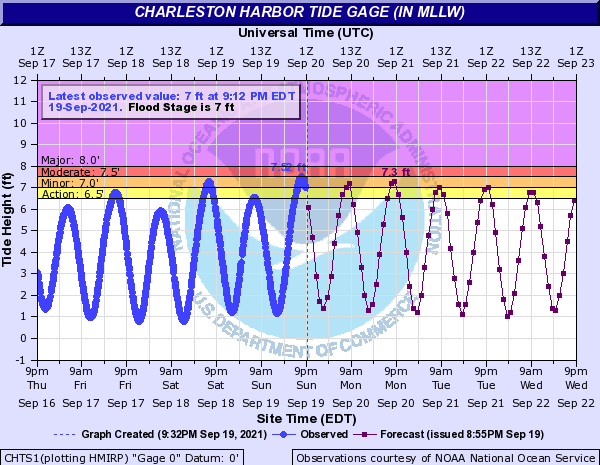
On top of this rain, we’ll need to watch tides very, very closely. Onshore flow combined with astronomical influences from the full moon will continue to drive higher-than-normal tides across the area. These tides could reach well into minor flood stage with both morning and evening high tides, particularly on Monday. Here are the times of high tide over the next few days:
- Monday: 8:02am, 8:38pm
- Tuesday: 8:50am, 9:18pm
- Wednesday: 9:31am, 9:56pm
With heavy rain possibly in the area for much of the next few days, the risk for flooding in Downtown Charleston and other coastal locations is certainly higher and will deserve our attention. A Flash Flood Watch may not be out of the question. Monitor forecasts closely over the next few days as there will be fine-tuning of the details.
Temperatures will run generally in the mid-70s in the morning and low 80s in the afternoon, owing to the heavy rainfall in the area. Wednesday will run a touch warmer ahead of a cold front.
By Thursday afternoon, the rain is out of here, and cooler and drier air will mercifully be settling in across the area, setting us up for a fantastic weekend. Lows in the low 60s will certainly stir up the desire for pumpkin spice, and highs topping out around 80° each afternoon will be mighty comfortable. With astronomical fall starting on Wednesday, the timing will be very seasonally appropriate (though temperatures will be a few degrees below mid-to-late September norms).