The week ahead: Coldest air of the season thus far arrives Tuesday and Wednesday
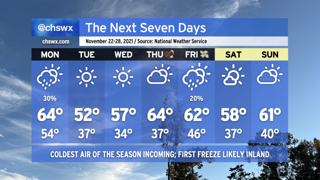
Today’s high of 73° could quite possibly be the last 70s we experience for the rest of November as a prolonged spell of below-normal temperatures is in the cards for the upcoming week. We start the abbreviated work week on a somewhat showery note as a cold front approaches the area during the day Monday. Rain chances tend to diminish as the front gets closer to the coast, but a few of you could see a few hundredths of an inch of rain during the day. The front gets through later Monday, and by Monday evening, cold air will rush into the area from the north as high pressure builds in.
We’ll start Tuesday in the mid-30s away from the locally cooler coastline, and could flirt with freezing conditions in some pockets well inland. Factor in the breezy north wind, and it’ll feel closer to the upper 20s in the morning. Highs will struggle to the low 50s in the afternoon with that persistent north wind continuing to make it feel a little cooler.
Calming winds and clear skies will provide excellent conditions for radiational cooling overnight Tuesday into Wednesday, and it appears likely that much of the area away from the coast will see its first freeze of the season with frost developing in other locations. Be ready to cover or bring in sensitive vegetation and make sure your pets have a warm place to be! Highs on Wednesday will run a little warmer than Tuesday, but still don’t look to crack 60°.
After another chilly start on Thanksgiving morning, temperatures will warm nicely into the mid-60s under partly cloudy skies. We could see a few showers on Black Friday as another cold front approaches the area with a reinforcing round of cooler air for the weekend, which looks to remain rain-free as of right now.