Friday & the weekend: Stormy, then turning quieter
We have a decent-looking weekend ahead, but first we need to get through Friday, which looks to be on the stormy side for a good bit of the day.
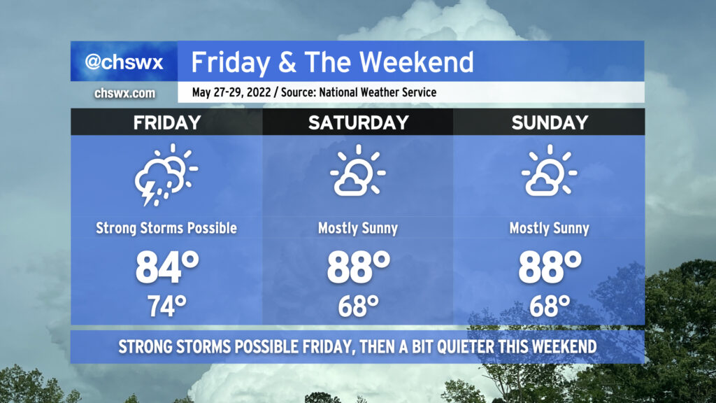
A frontal system will slowly press eastward throughout the day. Out ahead of it, showers and thunderstorms will develop and overspread the area to start the day, perhaps adding a bit of a challenge to the morning commute. This looks to be the first round of showers and storms. Models then indicate the atmosphere is primed to become more unstable in the afternoon, with a second line of showers and thunderstorms moving through the area in the early to mid-afternoon hours. This round of storms may be capable of producing some straight-line wind damage, large hail, or possibly even spin up a tornado. We’ll need to see how the morning round of storms evolve, but with the potential for a few severe storms tomorrow, I’d keep close to reliable and redundant ways to receive warnings.
Temperatures on Friday will only top out in the mid-80s at best given the expected rainfall in the area. Again, with any luck, the morning convection can help take the afternoon stuff down a notch or two, but we’ll wait and see if breaks in the clouds can form.
Showers and thunderstorms will taper off as Friday evening progresses, and by Saturday, we should see mostly sunny skies with highs topping out in the upper 80s. Dewpoints will be a touch lower, so it won’t feel as muggy as it has the past few days. This good weather continues into Sunday, as highs once again top out in the mid-to-upper 80s under mostly sunny skies. (Subtract a few degrees if you’re downtown for Spoleto, too, thanks to the seabreeze.)
In the meantime, let’s continue to hope for rain without the extracurricular severe weather activity. We definitely could use it; moderate drought continues in the Tri-County with parts of Beaufort and Jasper even dipping into severe drought.