Warm and muggy Thursday ahead of a potentially stormy Friday

Thursday looks to be another warm and somewhat muggy day as onshore flow keeps humidity up a notch or two. Temperatures will top out a little warmer than they did today, ending up around on the higher end of the mid-80s away from the coastline; factor in the humidity and we’ll see heat indices running in the low 90s. We look to stay rain-free, though, as drier air aloft stays in place for one more day.
Stormy Friday expected ahead of a quieter weekend
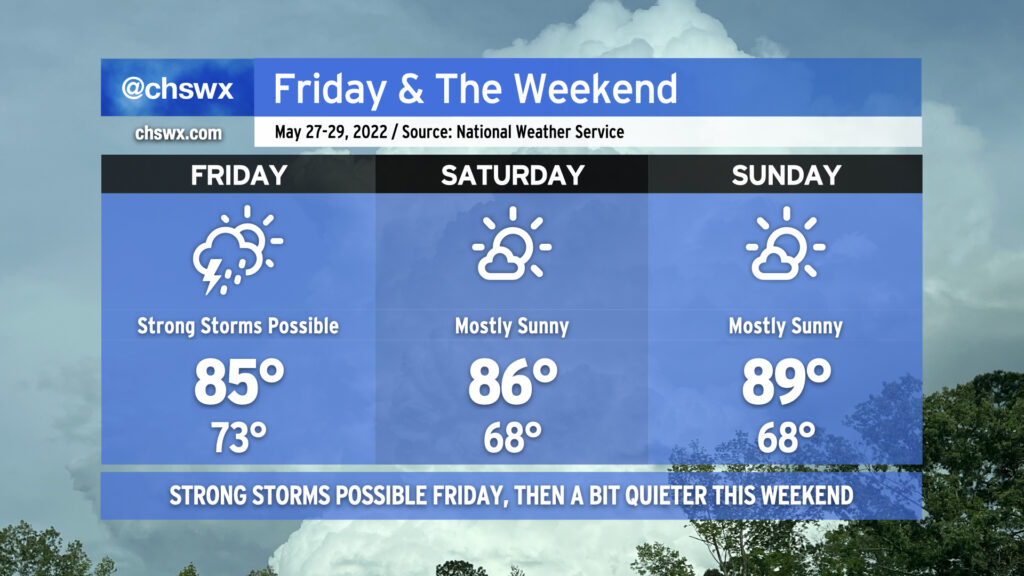
Friday has the looks of a bit of a stormy day across the Lowcountry as a cold front approaches the area. The environment will be favorable for thunderstorms with heavy rain producing minor flooding in spots, and will also possibly promote a few strong to severe thunderstorms as well with damaging wind gusts the main concern. It’s still a bit soon to pin down exact timing on rain, but model guidance suggests that we could see storms in the area from roughly mid-morning through evening. Highs should run in the mid-80s, potentially modulated by how much rain is around throughout the day. Stay tuned for updates!
Once the front gets through late Friday/early Saturday, we should see a trend toward quieter weather for the rest of the weekend as dry air punches in behind it. Lows will run a touch cooler in the upper 60s both Saturday and Sunday, with mid-80s on Saturday and upper 80s on Sunday, both punctuated by mostly sunny skies. The only potential fly in the ointment could be if the front stalls a little further northwest than currently expected. For now, though, guidance is in good agreement that it will clear us enough to not cause any additional issues.
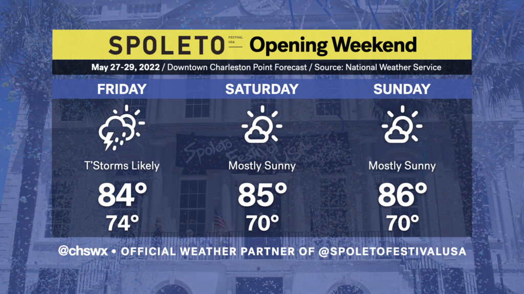
Spoleto: Unsettled opening, but turning nicer for the first weekend of the festival
This year, @chswx is the official weather partner of Spoleto Festival USA! Follow along throughout the next few weeks for weather updates specifically targeted to the festival. (For any cancellations or venue changes due to weather, be sure to be following the festival on Twitter, Instagram, and/or Facebook.)
Opening Ceremonies at City Hall: We are going to be watching the risk for showers and thunderstorms carefully for Friday afternoon as the festival officially gets underway with the Opening Ceremonies at City Hall. Specific arrival timing for inclement weather remains somewhat unclear this far out; it’ll be largely driven by the cold front’s eastward progress, which hasn’t had great run-to-run consistency in guidance just yet. We should start to get a much better idea as we get into Thursday’s guidance cycle, though, so stay tuned! Temperatures look to generally run in the low-to-mid 80s downtown, and could run a tick or two lower depending on the proximity of thunderstorms and overall cloud cover.
Opening Weekend: The rest of the weekend looks pretty good downtown, if not a little warm and a little muggy (though this is what we get the last week of May, typically). Showers and thunderstorms are not expected, though, and the evenings should feel rather comfortable for catching performances at Cistern Yard.