Friday & the (holiday) weekend: Unsettled start tapers off a little bit around the Fourth
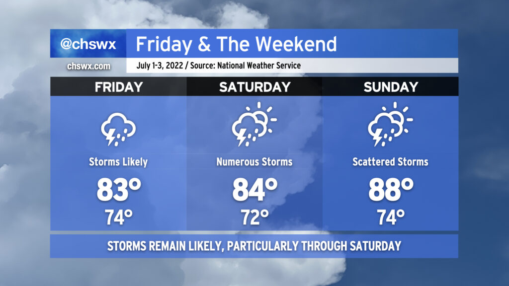
After some of us got a day to dry out, showers and thunderstorms look to resume possibly as early as late tonight as a disturbance aloft possibly spawns a little surface low in southeast Georgia. This possible low, if not the associated surface trough, will help to keep numerous showers and thunderstorms in the forecast for Friday and into Saturday as well. We could see storms ongoing Friday morning for the commute, so be ready to take it a little slower on the roads. Heavy rain and lightning will be the primary issues from any thunderstorms. The atmosphere remains juiced with plenty of moisture: precipitable water values (the amount of water you can wring out from a column of air) will continue to run very close to 2″. This moisture combined with ample instability will likely lead to some pockets of very heavy rain rates and a risk of minor flooding to go along with it. Also, it’s worth noting that high tide will peak around 10:17 AM in Charleston Harbor. Guidance does show some heavy downpours coming ashore ahead of and around this time, which could enhance the flood threat in coastal communities including downtown Charleston. With the prevalent storms and cloud cover, highs should top out in the mid-80s at best. It’ll be quite humid, though, and so heat indices could run up toward 90° especially if some sun peeks out.
Saturday looks like it could get off to a similar start as broad surface low pressure may be moving through the area during the morning. Additional showers and thunderstorms could then fire in the afternoon in the wake of the low depending on how well the seabreeze ultimately develops. Temperatures should stay capped in the mid-80s once again, owing to the unsettled weather that’s expected. Something tells me the details around Saturday will be refined some more, too, so stay tuned.
Sunday will be a little more summer-like in nature with more widely scattered thunderstorms, particularly in the afternoon. Temperatures will rebound from previous days into the mid-to-upper 80s.
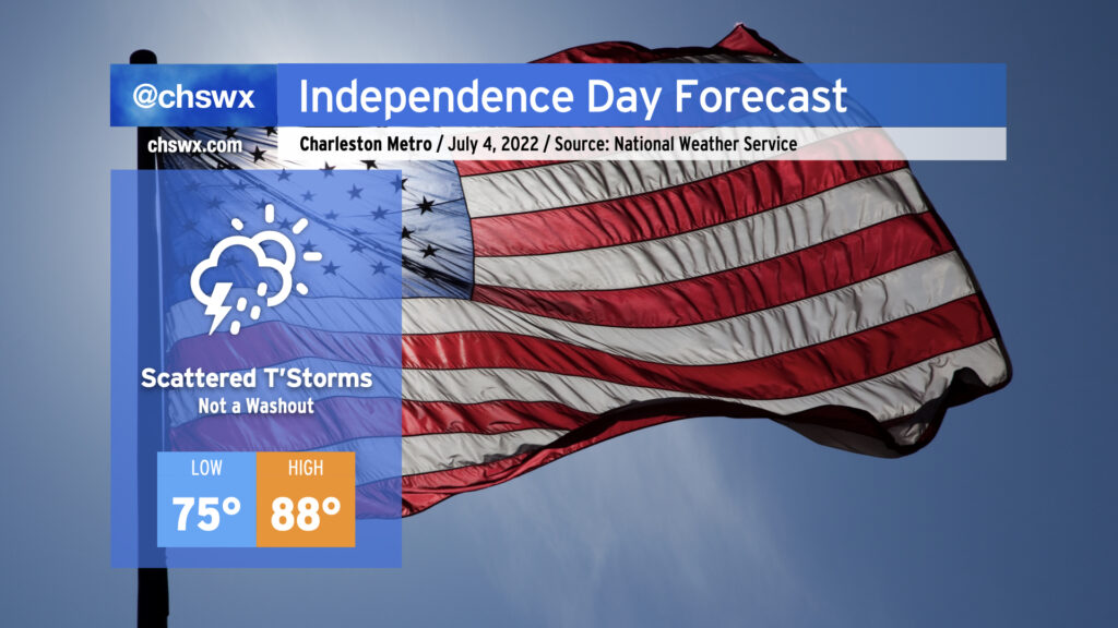
Scattered thunderstorms will continue to factor into the weather equation for the Fourth of July. Outside of storms, it’ll be a solidly warm and humid early July day. Highs will top out in the upper 80s, but humidity will make it feel closer to the low-to-mid 90s. Early indications from the global models are that thunderstorms could affect the beaches in the morning and early afternoon and then steadily work inland with the seabreeze as the afternoon progresses. Overall, I’d expect we’ll be alright for fireworks displays around the area as we should be dry in the evening. As higher-resolution data comes in over the weekend, we’ll be able to fine-tune this forecast further. Stay tuned!