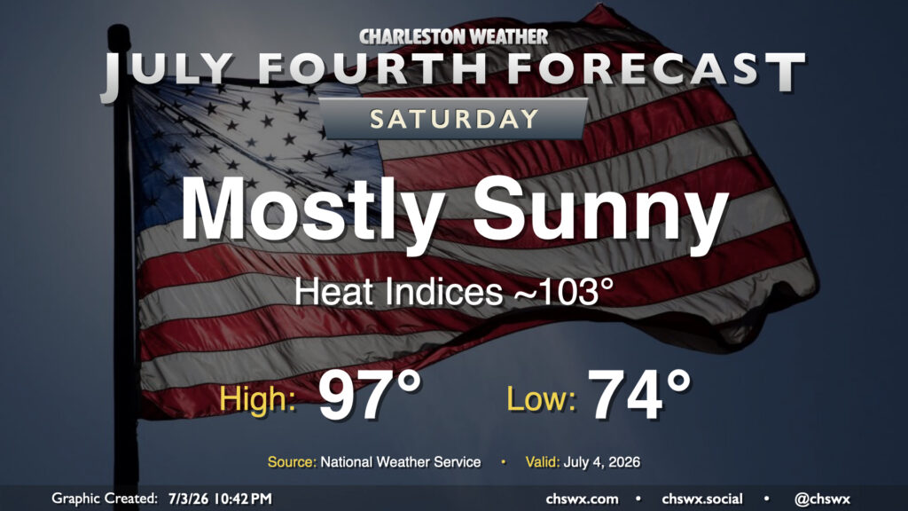
The 250th anniversary of our independence will be a warm one, with highs approaching the record of 98° set in 2023. Lingering dry air, though, will keep thunderstorms at bay and heat indices from getting too far out of hand. Still, we can expect heat indices to push into the 100-105° range in the afternoon, so you’ll want to make sure you’re getting plenty of fluids and time in the shade. We’ll have a few clouds from time to time, but otherwise expect plenty of sunshine, especially at the beaches. Make sure you’re applying sunscreen regularly as the UV index is expected to reach 10 during the height of the day. Have a safe and enjoyable holiday!
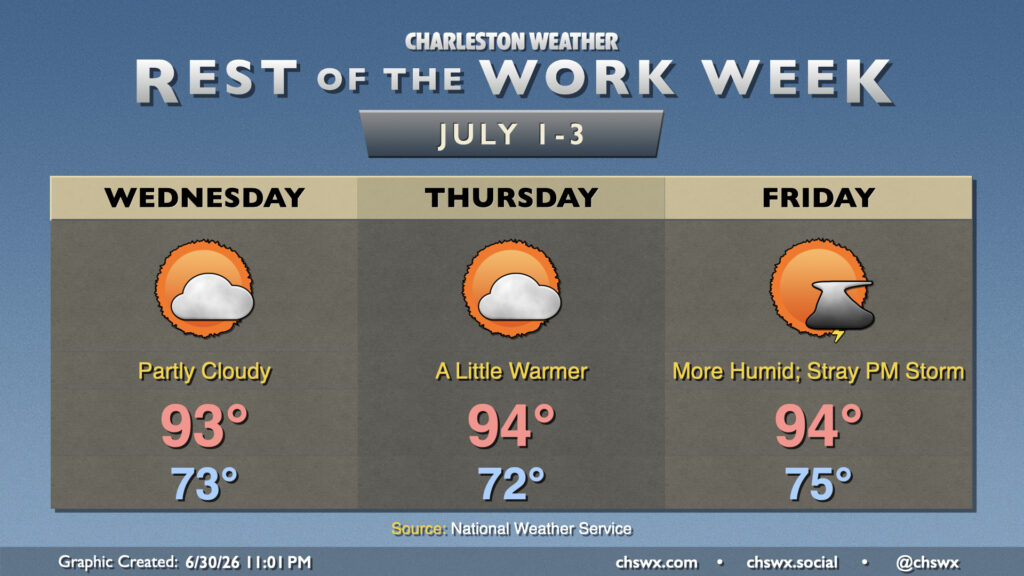
High pressure remains the primary weather driver at the surface and aloft for the rest of the work week, keeping temperatures toasty. Northeast flow over the next couple days, though, helps to bring in some drier air, which will keep heat indices from popping off too much. Wednesday starts in the low-to-mid-70s, with temperatures warming into the low to mid-90s in the afternoon under generally partly cloudy skies. The aforementioned stacked high pressure and influx of drier air will keep convection to a minimum.
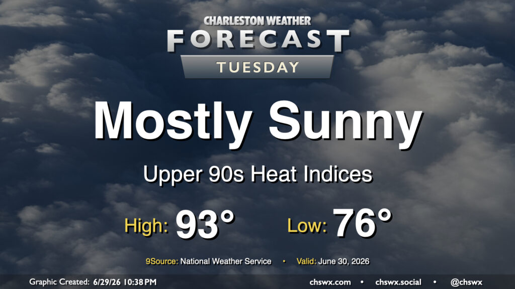
High pressure wedging southward into the Lowcountry and the resulting northeasterly flow will take a slight edge off the heat for Tuesday after another day in the mid-90s on Monday. It’ll still be a steamy start, though, and the low of 78° will get awfully close to the record warm low temperature of 79° set in 2024. We’ll warm into the low 90s in the afternoon, but dewpoints running in the low to mid-70s will drive the heat index into the upper 90s (standing in contrast to the mid-100s we’ve felt the past few days). High pressure ridging in aloft will put a lid on thunderstorm activity, though some of the convection-allowing models still try to squeeze out a few showers in the afternoon. Rain is highly unlikely, though, so don’t count on it.
As is customary for the Lowcountry, heat and humidity will feature prominently in the Independence Day forecast, with some scattered afternoon and evening thunderstorms to cool some of us off. Before thunderstorms fire, we should see temperatures reach into the upper 80s to low 90s away from the somewhat cooler (but still quite humid) coastline. This warmth when combined with mid-70s dewpoints will yield heat indices in the low 100s for tomorrow. Be sure to get plenty of water and shady breaks if you’re outside for an extended period. (Don’t forget the sunscreen, either.)
By 1-2 PM, we should begin to see some showers and thunderstorms start to initiate along and inland of the seabreeze circulation. We’ll want to watch the 1-4PM period closely for the greatest risk for lightning to the beaches as there will be more than ample instability for strong updrafts to develop. (Remember: When thunder roars, go indoors!) Places that get caught under a thunderstorm will not see it move too terribly much during its lifecycle; with precipitable water values at or exceeding 2″, we could see some pockets of rather heavy rain in a short time in some spots. Wind shear is nearly nonexistent, so severe weather looks quite unlikely outside of the potential for a wet microburst somewhere. Severe potential aside, lightning makes all thunderstorms dangerous, so please do move indoors if you see lightning or hear thunder.
The good news, though, is that the Fourth of July will not be a complete washout. We should see storms begin to clear the Tri-County by early evening as the seabreeze progresses inland, and fireworks shows should be very much go for liftoff. Have a safe and fun holiday!
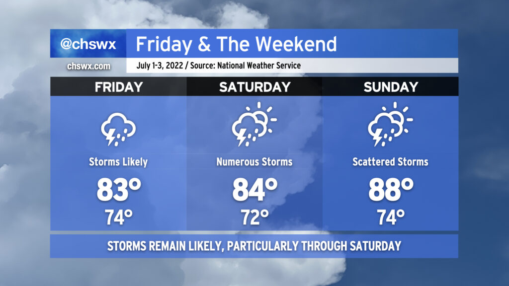
After some of us got a day to dry out, showers and thunderstorms look to resume possibly as early as late tonight as a disturbance aloft possibly spawns a little surface low in southeast Georgia. This possible low, if not the associated surface trough, will help to keep numerous showers and thunderstorms in the forecast for Friday and into Saturday as well. We could see storms ongoing Friday morning for the commute, so be ready to take it a little slower on the roads. Heavy rain and lightning will be the primary issues from any thunderstorms. The atmosphere remains juiced with plenty of moisture: precipitable water values (the amount of water you can wring out from a column of air) will continue to run very close to 2″. This moisture combined with ample instability will likely lead to some pockets of very heavy rain rates and a risk of minor flooding to go along with it. Also, it’s worth noting that high tide will peak around 10:17 AM in Charleston Harbor. Guidance does show some heavy downpours coming ashore ahead of and around this time, which could enhance the flood threat in coastal communities including downtown Charleston. With the prevalent storms and cloud cover, highs should top out in the mid-80s at best. It’ll be quite humid, though, and so heat indices could run up toward 90° especially if some sun peeks out.
Saturday looks like it could get off to a similar start as broad surface low pressure may be moving through the area during the morning. Additional showers and thunderstorms could then fire in the afternoon in the wake of the low depending on how well the seabreeze ultimately develops. Temperatures should stay capped in the mid-80s once again, owing to the unsettled weather that’s expected. Something tells me the details around Saturday will be refined some more, too, so stay tuned.
Sunday will be a little more summer-like in nature with more widely scattered thunderstorms, particularly in the afternoon. Temperatures will rebound from previous days into the mid-to-upper 80s.
After record rainfall today — 1.87″ of rain at the airport breaks the record of 1.54″ set in 2000, while stations in West Ashley picked up 2.5-3″ — more storms are on the horizon for the next few days as we remain within a very humid airmass with plenty of upper-air and surface features to help spur on shower and thunderstorm development.
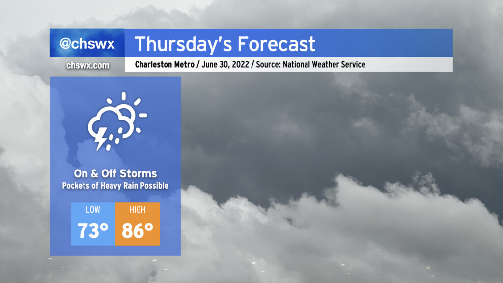
Thursday looks to go similarly to the past couple days, though there may not be quite as much coverage as we’ve seen thus far this week. We could see showers and storms forming early in the day near the coast, with storms becoming scattered to numerous while translating inland with the seabreeze throughout the afternoon. With precipitable water values near 2″, we once again could see pockets of very heavy rainfall. The past couple days have seen a couple 4″ bullseyes, and I can imagine that will be the case somewhere again tomorrow. The severe weather risk remains very low given the very saturated atmosphere, but lightning and isolated bouts of excessive rainfall will make any thunderstorm dangerous. High temperatures will remain suppressed in the mid-80s, though the humidity will still be rather swampy.