Rest of the work week: Still hot and humid with more afternoon storms
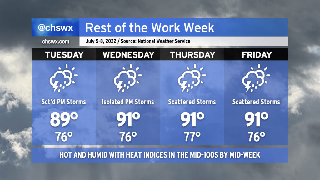
The rest of the work week will remain quite warm and steamy as a tropical airmass stays in the area for the next several days. Tuesday and Wednesday will feature more typical summertime popup showers and thunderstorms in the afternoons while heat indices soar into the 100s both days (with 105°+ heat indices possible Wednesday). As is typical, a stronger storm or two can’t be ruled out, and given the airmass in place, pockets of heavy rain could develop, perhaps causing some localized flooding. We’ll also want to keep an eye on any disturbances that develop and ride around the periphery of an upper ridge that’ll be centered to our west; both the NAM and GFS seem to be trying to sniff something out along these lines for late Wednesday/early Thursday. Only time will tell whether this is legit or not.
We’ll see an uptick in shower and storm coverage Thursday and Friday as the ridge retrogrades a little further west and atmospheric moisture increases. We could see precipitable water values in excess of 2.2-2.3″ as we close out the work week, which would be a ripe atmosphere for very heavy rain in any thunderstorms that can develop. Scattered coverage of afternoon thunderstorms appears probable. Temperatures will remain quite warm, with highs in the low 90s, lows in the mid-to-upper 70s, and heat indices probably running over 105° once again each afternoon before thunderstorms fire.
In other words: It must be July in the Lowcountry.