The week ahead: On and off showers and storms turn more numerous later this week
Standard warm & muggy August weather will continue this week with an uptick in shower and thunderstorm coverage coming thanks to a stalling cold front.
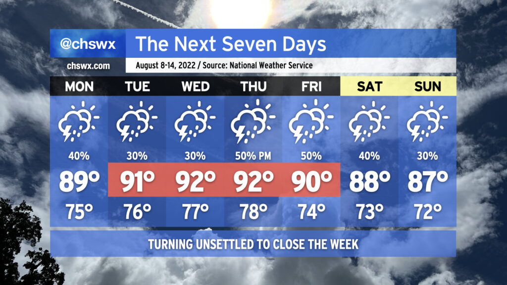
Monday looks to remain somewhat on the unsettled side as a mid-level feature known as a TUTT (tropical upper-tropospheric trough — say that five times fast!) continues to whirl into the area. This should help kick off some isolated to scattered showers and storms to start the day near the coast. Eventually, we should see the seabreeze begin to push inland, and along with it, more isolated to scattered showers and storms, with rain chances moving westward with time. Temperatures will generally top out in the upper 80s to around 90° in the afternoon; heat indices will approach 100°.
Expect additional seabreeze-driven showers and storms Tuesday and Wednesday, with highs topping out in the low 90s each afternoon. Storm coverage ratchets up a little beginning Thursday afternoon as a front approaches the area; scattered to numerous storms are possible Friday with the aforementioned cold front approaching the area. We’ll stay unsettled into the weekend, with high temperatures trending down a little further into the 80s in the afternoons thanks to onshore flow and scattered storms.
The severe weather risk this week is low, but an isolated strong or severe storm can never be totally ruled out at this point in the year. Heavy rain and lightning will be the main concerns from thunderstorms, and slow storm motions at times may produce areas of isolated flooding. All in all, nothing terribly out of the ordinary for early-to-mid-August — just make sure the rain gear is close and that your outdoor activities have indoor backup plans.