Friday & the weekend: Mostly pleasant, maybe a stray Sunday shower
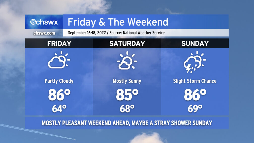
We’ve got a much nicer-looking weekend ahead than we had last weekend as a few more days of comfortable temperatures and generally quiet weather continue across the area. Partly cloudy to mostly sunny skies will generally be the rule each day. We start Friday back in the mid-60s for one more day before dewpoints begin to creep up heading into the weekend, nudging lows up to the upper 60s for Saturday and Sunday. Highs, though, will remain in the mid-80s — right at normal for this point in the year.
Sunday’s looking like the only day that could see a little shower and storm activity. A wave of low pressure is expected to form along a stationary front well to our south, with a coastal trough developing on its northern flank. This may be enough to push a few showers and storms inland from the Atlantic, but rain chances are slight at best; many of us should stay rain-free. Otherwise, though, quiet weather looks to persist well into next week as ridging develops aloft. Temperatures will warm a bit more under this ridge, and it’ll feel a touch more humid with dewpoints climbing to around 70° beginning Saturday night and Sunday, but rain chances remain next-to-nothing heading into next week. (We’ll take all the drying out we can get.)
Tropical update: TD 7 becomes Fiona, to threaten the Antilles
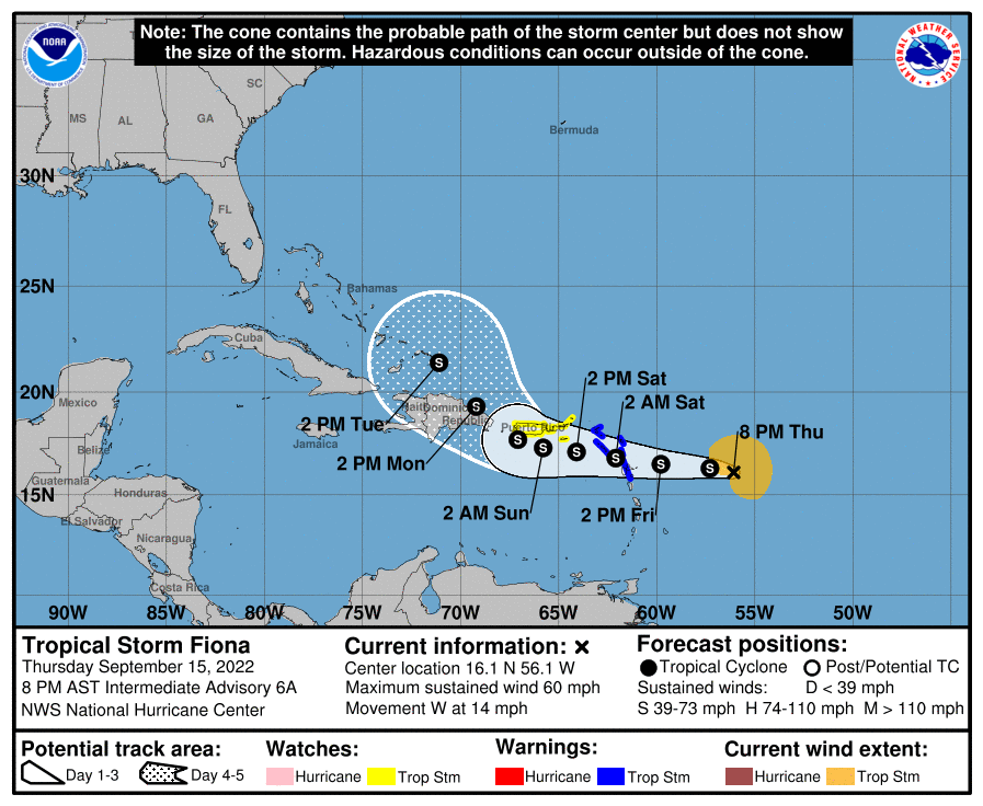
Tropical Storm Fiona was named with the 11pm advisory yesterday (Wednesday). As of this evening, it has 60 MPH maximum sustained winds and is moving west at 14 MPH. Tropical Storm Warnings are up for the northern Lesser Antilles, with a Tropical Storm Watch in effect for Puerto Rico. Fiona is in a somewhat hostile environment, with a vast majority of its thunderstorms sheared well to the east of the center of circulation. Shear will continue to have a negative effect on Fiona over the next few days as it continues to move westward, which should limit it to tropical storm strength.
Guidance is quite mixed when you get beyond three days or so. A stronger Fiona is more likely to recurve away from the US completely; a weaker Fiona will continue more of a westward motion for a little while longer. Some guidance puts it in the Gulf by next weekend while other members (a majority of them, for what it’s worth) have it harmlessly whisked away from us. So far, the trend in the guidance — and the official NHC forecast — has been to carry it more westward before making that turn. How far west, though, remains anyone’s guess: how Fiona reacts to shear and land interaction with the Antilles (especially approaching Hispaniola) is going to have a hand in where it goes.
The bottom line for now is that there’s no imminent threat to us here in the Lowcountry. We’ll keep an eye on it! Check in with forecast updates occasionally, but there’s nothing here to get worked up over just yet, if at all.