Weekend forecast: Looking good, stray shower possible Sunday
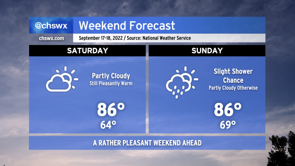
We’ve got a pleasant weekend ahead, despite humidity creeping back up for Sunday with the specter of a stray shower or two in the mix.
Saturday’s the pick day, in my view: it’ll be the last day of the lower humidity we’ve been experiencing over the past few days, which will keep that high of 86° feeling like it’s 86°. On Sunday, we’ll see a little bit more in the way of humidity working back into the area as dewpoints creep back up to around 70° in the afternoon, causing that high of 86° to feel closer to 90-91°. A stray shower isn’t out of the question, but the vast majority of us look to stay dry.
Tropical update: Fiona working through the Antilles; to become a hurricane by the middle of next week
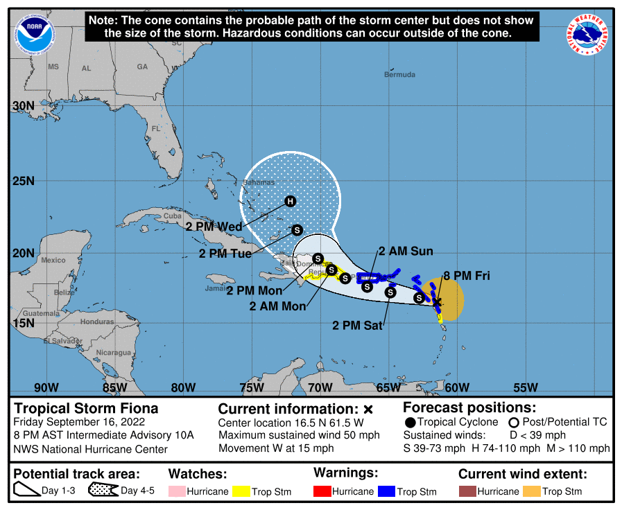
This evening, Tropical Storm Fiona is moving through Guadeloupe with eyes on the British Virgin Islands and Puerto Rico over the weekend before getting to the Dominican Republic overnight Sunday into early Monday morning.
Fiona’s maximum sustained winds are at 50 MPH as it continues to experience westerly wind shear, though recent satellite imagery suggests storms are trying to hang on closer to the center than they were last night. NHC has Fiona as a mid-range tropical storm through tomorrow afternoon, with some strengthening to a higher-end tropical storm expected as it passes south of Puerto Rico. It may make landfall as a 70 MPH tropical storm, just shy of hurricane status, on the Dominican Republic Sunday afternoon. From there, some land interaction should weaken it slightly before it emerges back over the Atlantic Monday evening, approaching the Turks and Caicos as a strengthening tropical storm. Fiona is now forecast to become a Category 1 hurricane by Wednesday as it moves east of the Bahamas.
There is obviously still a lot of time for things to change, but NHC’s thinking goes well with today’s model trends favoring a stronger Fiona being picked up by a trough and recurving before reaching the United States. All of the reliable track guidance is on board with the recurve, though there’s still some question of how far west it gets before the turn. There’s still plenty of time to watch Fiona — and plenty of time for things to change — but the consistency in the general idea of the guidance so far is positive for us. Stay tuned…