Sunday: Stray shower possible, but most stay dry
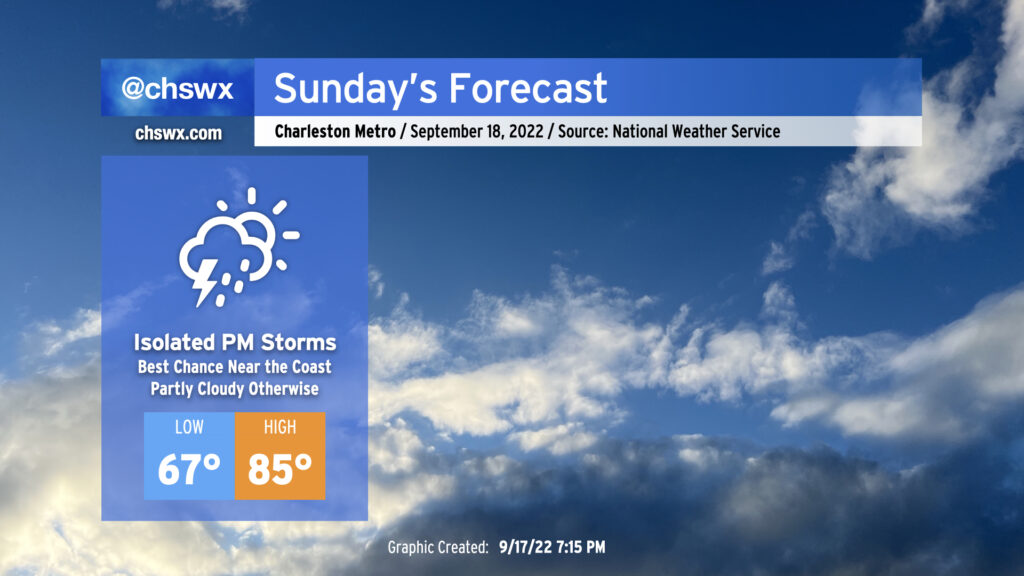
A coastal trough will bring our first mentionable shower and storm chances in a few days for Sunday as a few showers and thunderstorms could drift ashore from time to time. While some of the high-resolution guidance has been awfully aggressive about rainfall amounts and how far inland measurable rain gets, generally expect the best chance for any showers toward the coast. An isolated downpour can’t be ruled out particularly if deeper moisture can make it ashore. With all that said, the rain chances are far from substantial enough for canceling any outdoor plans — just keep an eye out tomorrow in the unlikely event a storm approaches.
Temperatures will continue to run right around normal for this point in the year. We’ll start the day in the mid-to-upper 60s across much of the metro (low 70s at the beaches) before temperatures head up to the mid-80s in the afternoon. Dewpoints are forecast to approach 70° in the afternoon, and that’ll yield heat indices in the low 90s at peak heating.
We’ll see similar conditions on Monday before a ridge of high pressure asserts control at the surface and aloft. We’ve got a few hot days in store next week, with air temperatures in the low 90s possible mid-week as we reach the autumnal equinox and Fall begins. A dry front will usher in a shot of cooler and drier air just in time for the weekend, though. NWS’s opening bid for next Saturday: Low 66°, high 81°, mostly sunny skies, dewpoints in the low 60s. (Can we fast-forward?)
Tropical update: Fiona approaching hurricane strength, likely to recurve
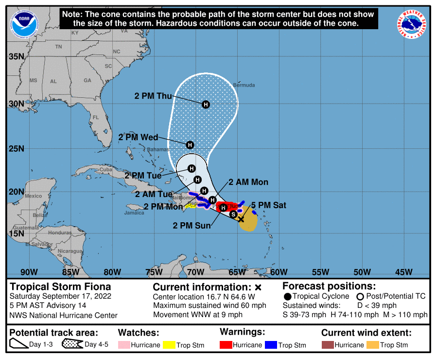
Hurricane Warnings are up for Puerto Rico this evening as Tropical Storm Fiona, which as of 5PM had max winds of 60 MPH, was starting to get better organized to make a run for hurricane intensity possibly as soon as later tonight. Fiona is moving WNW at 9 MPH and should approach landfall on Puerto Rico by tomorrow morning.
From there, Fiona will brush by the Dominican Republic as it is expected to begin a more northwesterly motion. It’ll likely scrape the eastern Bahamas before turning more northerly Tuesday into Wednesday. From there, expect Fiona to turn a little more toward the northeast and accelerate, potentially threatening Bermuda with a sideswipe late Thursday into Friday.
As for our impacts, it looks increasingly like we’ll see an uptick in waves (and a corresponding uptick in rip current risk). Barring an unexpected change, though, confidence is certainly high in the recurvature scenario. Fingers remain strongly crossed!
A little retro t-shirt fun

With the sudden abundance of rain-free conditions, I found myself with a little creative time and got on a bit of a retro Weather Channel kick while playing around in Pixelmator Pro, and whipped up a @chswx logo that looks like it might have if this started back in 1991. Friends ate it up, so I figured I’d slap it on a shirt for anyone who wants to sport their excellent taste in social media weather while paying homage to one of the main things that inspired me (and a lot of other pro meteorologists my age!) so many years ago, when The Weather Channel was all weather and was straight and to the point about it with a smile. If you buy one, I’d love to see it!