The week ahead: Quiet weather, fall feel
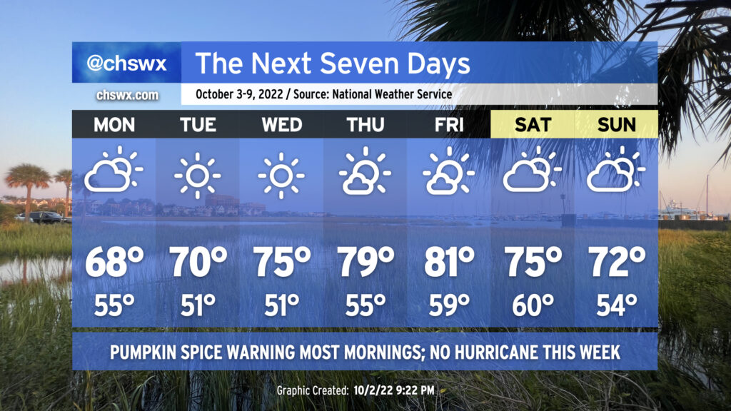
So first and foremost: There will be no hurricane this week. Quite the opposite, in fact: it should be a very nice week of weather, with a little something for everyone — sweater fans will love Monday in particular, while by mid-week we’ll be comfortably warm before a dry cold front knocks temperatures back over the weekend.
Cloud cover will be persistent on Monday (with a tiny chance of a shower), keeping temperatures perhaps limited to the upper 60s. Cloud cover should scour out by Tuesday as a warming trend takes hold under sunny skies. We’ll be in the upper 70s to low 80s by Thursday and Friday ahead of the frontal passage. The front will be moisture-starved as it passes through on Saturday, likely only being able to yield an increase in cloud cover for the weekend, but we look to remain rain-free. Saturday looks to run a little warmer than Sunday right now, but both days should be excellent to get outdoors.
The only weather concern of note will be the potential for minor coastal flooding with the afternoon high tides. The moon will be at perigee (passing closer to Earth) approaching a full moon on October 9, which will help increase the water levels during times of high tide. Northerly wind directions will help keep these tides from getting out of hand, though as high pressure wedges southward over the weekend and winds turn more northeasterly, we may see some higher water levels. Stay tuned as those details work out.
Tropical update: New area of interest approaching the Caribbean
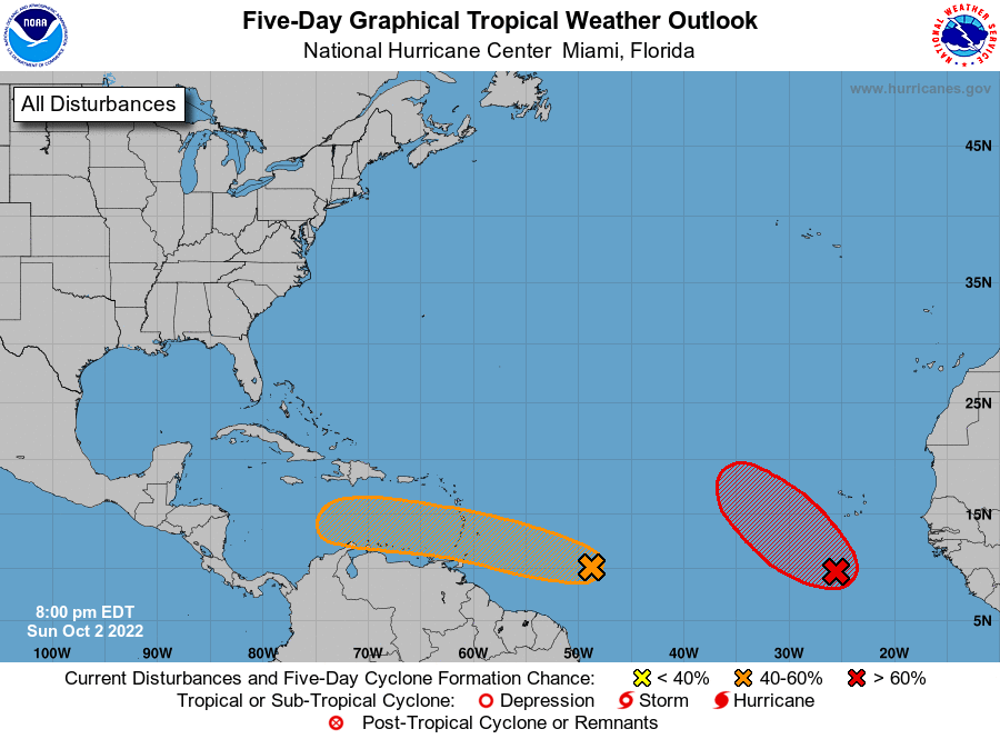
A disturbance approaching the Windward Islands and eventually the Caribbean Sea has a 40% chance of becoming a tropical cyclone in the next five days. It’s been tagged as Invest 91L, and right now will just be monitored by NHC as it heads into the Caribbean this weekend. Model guidance is mixed on whether this ultimately gets going. For now, it’s nothing to worry about — I’ll let you know if it becomes one.
There is a second wave south of the Cabo Verde Islands that looks like it will be our next depression by the end of this week; the next name on the list is Julia. This storm will primarily be of concern to shipping interests across the eastern Atlantic.