Rest of the work week: Warming up, some tidal flooding
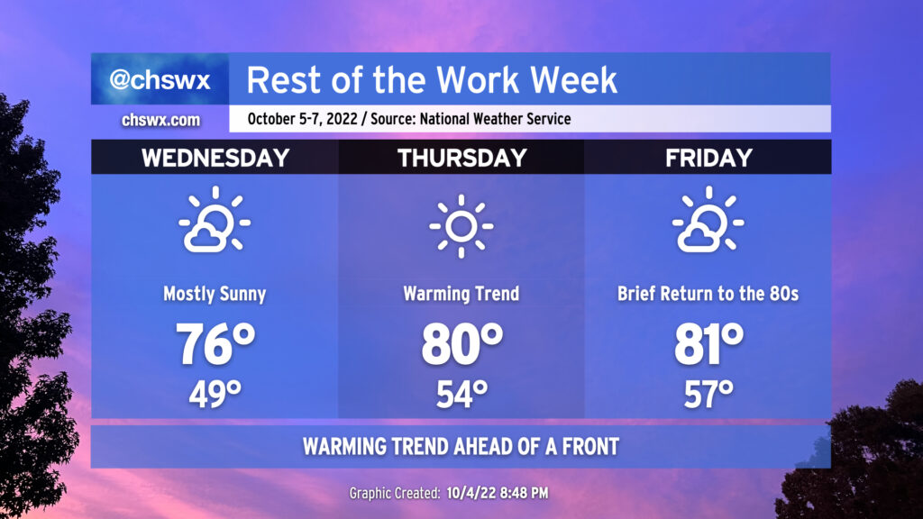
We’ve got another chilly start coming up on Wednesday morning as clear skies and light winds allow for good radiational cooling conditions. We should see temperatures take a dip back into the upper 40s by daybreak (away from the barrier islands and downtown, anyway). From there, a warming trend will commence as a pesky trough associated with the remnants of Ian (yes, really) finally begins to lift away from the area. High pressure will continue to build in from the west, and the resulting downslope flow will begin to help warm temperatures in earnest. Wednesday’s high will top out in the mid-70s under mostly sunny skies. The warming trend continues into Thursday and Friday, with lows bottoming out in the mid-50s and highs reaching around 80-81° each afternoon ahead of a cold front which will swing through Saturday, sending temperatures well back below normal for this point in October by Sunday and the following week. No rainfall is expected; indeed, quite the contrary as mostly sunny skies will continue to dominate.
The only weather hazard of note will be the potential for coastal flooding with the afternoon high tides particularly Thursday and again on Friday (and likely through the weekend) as the moon turns full. Southwesterly winds will keep any coastal flooding to a dull roar Wednesday and Thursday, but we may see water levels creep well into minor flood stage, perhaps approaching moderate flood Friday evening. As the front gets through on Saturday, winds turn northeasterly, which is a very favorable wind direction for coastal flooding, so we’ll need to continue to monitor evening high tides through the weekend for additional rounds of coastal flooding.
Tropical update: TD Twelve forms, is no threat; watching the wave approaching the Windwards
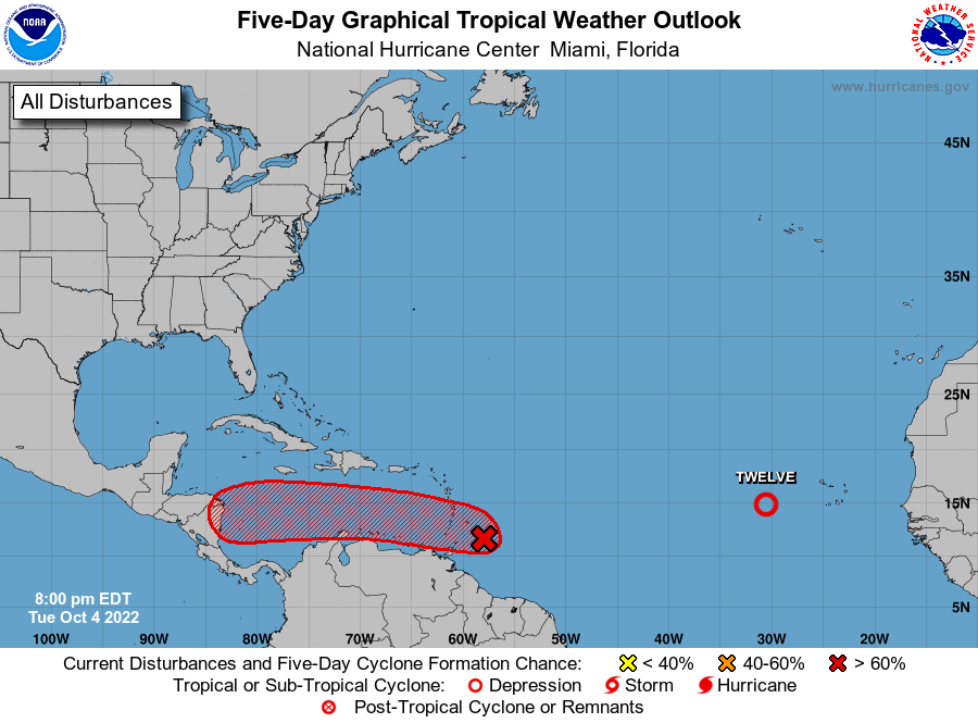
There remain two areas of interest in the tropics this evening. The first is newly-christened Tropical Depression Twelve, which isn’t expected to have a terribly long life but has a shot at becoming a tropical storm briefly over the next couple days. It will only be a concern for maritime traffic near the Cabo Verde islands and is not a threat to the Lowcountry. (The next name on the list is Julia.)
Meanwhile, Invest 91L, the tagged area of disturbed weather we discussed last evening, is approaching the Windward Islands this evening with gusty winds and heavy rain. Hurricane Hunters were recently in this storm, and did not find evidence of a closed-off center of circulation yet, so it remains just a wave for now as it looks to enter the Caribbean over the next day or so. The National Hurricane Center gives it a 70% chance to develop into a tropical cyclone over the next five days as it approaches Central America. For now, this system doesn’t appear to be a threat to us here at home; models keep a ridge of high pressure extending across the Gulf well into Mexico that should continue to steer this storm westerly. Given its location, we’ll continue to keep an eye on it for any misbehavior.