The week ahead: First significant rain since Ian possible Thursday
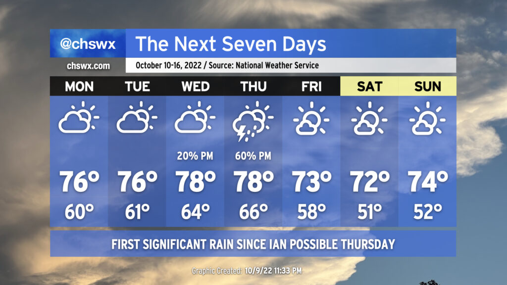
On balance, the week ahead will be primarily quiet weather-wise, with the exception of Thursday as a cold front presses through the area, bringing along some showers and thunderstorms. Highs through Thursday will remain a little below normal, generally running in the mid-to-upper 70s. Conversely, cloud cover and increased moisture will keep lows at or a little above normal through Thursday morning, with lows in the mid-60s expected Wednesday and Thursday right ahead of the front.
The weather on Thursday could bear watching for a few stronger storms depending on how much instability can develop. We’ll have good wind shear in place, but the instability — as is often the case as we head into the cool season — is going to be the main question mark. More likely, though, Thursday will represent the first significant rain for the area since Hurricane Ian, though amounts certainly won’t approach Ian-like numbers.
Once the front is through, we will see cloud cover decrease and temperatures once again head well below normal for Friday and the weekend, which is looking pretty good. Highs through this period will run in the low 70s, while lows will bottom out in the upper 50s Friday and the low 50s Saturday and Sunday, several degrees below normal for this point in the year.
Coastal flooding remains a concern through the first part of the week
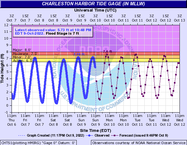
Concerns for coastal flooding given the recent full moon and northeasterly winds continue through at least mid-week. Minor to moderate coastal flooding will be possible with the morning high tides, with minor coastal flooding possible with evening high tides through Tuesday. Be ready for disruptions to travel in downtown Charleston, particularly in the mornings.
Monday morning’s high tide is expected to peak just shy of 9am, and coastal flooding will be possible within a couple hours either side of high tide. Remember, sunny day flooding is salt water, and this could have negative consequences for your car if you try to pass through it. Find alternate routes if at all possible.
Tropical update: Julia makes landfall in Nicaragua
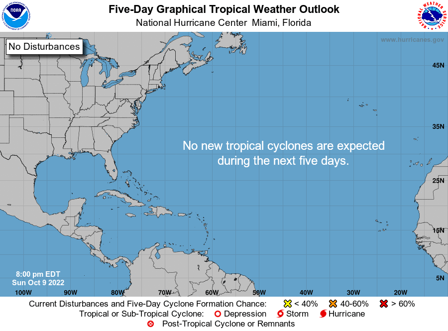
Hurricane Julia made landfall earlier today in Nicaragua as a category 1 storm on the Saffir-Simpson Wind Scale with maximum winds of 85 MPH. Julia has since emerged into the eastern Pacific basin as a much weaker tropical storm with maximum winds of 40 MPH; it’s expected to move parallel to the El Salvador coast and weaken to a depression over the next day before dissipating entirely. (Its moisture may get funneled up into the Southeast, though, in association with the trough digging into the area later this week.)
After Julia, we look to get a bit of a breather: NHC doesn’t foresee any new tropical cyclone activity in the Atlantic basin within the next five days, which is always welcome news from the folks down in Miami.