Friday & the weekend: Great weather ahead
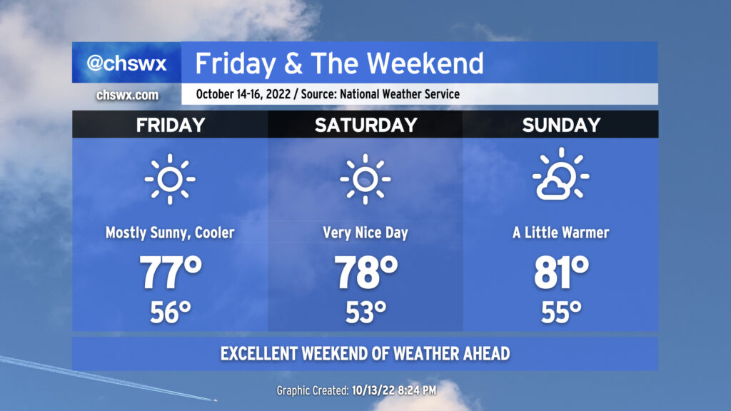
No weather worries as we head into Friday and the weekend as comfortable temperatures take hold behind a cold front coming through overnight.
Friday looks outstanding. Lows in the mid-50s will rebound to the mid-to-upper 70s under full sunshine. Dewpoints below 50° (away from the coast, anyway) will keep things quite comfortable. Winds behind the front will be generally light, generally around 5 MPH from the north. Friday could be one of those rare Severely Nice Weather Alert Days around here, that’s for sure.
Saturday could also qualify as a Severely Nice Weather Alert Day. We’ll start a little cooler — low 50s will be common away from the warmer coastline — and head into the upper 70s under continued uninterrupted sunshine. Winds will be quite light, generally out of the east.
We begin to turn a touch warmer on Sunday as winds go southwesterly ahead of our next front. (More on that in a minute.) Temperatures will run in the low 80s with a few clouds in the afternoon. Sunday’s weather remains excellent, though, and will be a little more palatable to those who like it a little warmer. Something for everyone this weekend!
Sweater weather watch for next week
Get those sweaters and hoodies ready: a legitimate taste of fall is in the offing for the middle of next week. A cold front will come through next Monday with a few showers associated with it as we get into the afternoon hours. Once that front gets by overnight Monday, though, temperatures should take a real tumble. The forecast highs for Tuesday through Thursday look to run generally in the mid-60s, while lows look to bottom out in the low to mid-40s for the first time since April 20. To put this in a bit of perspective: These temperatures are more in line with December normals than mid-October normals. We’ll see how this ultimately pans out, but it’s likely welcome news for fall weather fans.
Tropical update: Karl’s still heading to Mexico, one other area of interest
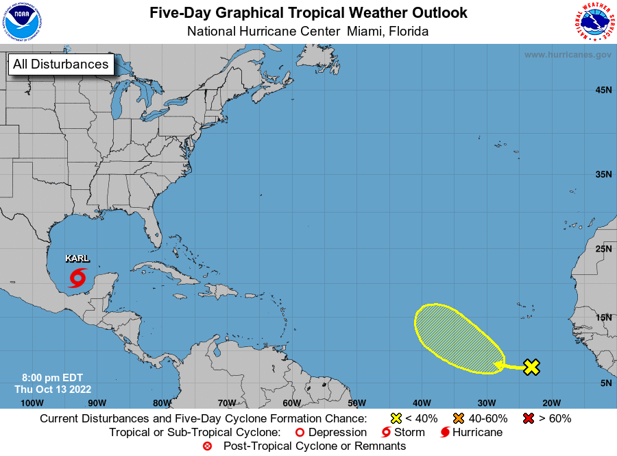
Peeking into the tropics tonight — which is admittedly a weird pivot after talking about sweaters and hoodies — we continue to see Tropical Storm Karl hanging around in the Bay of Campeche as it begins to make its final approach to landfall on Mexico this weekend. It remains zero threat to the Lowcountry.
The National Hurricane Center also pointed out a wave shy of 23° W that has a slight chance of development over the next few days. However, the environment that wave will run into is highly sheared and thus quite hostile to tropical cyclone development, so not too much is expected here. This, too, poses no threat to us here at home.
Elsewhere in the tropics, aside from the usual weak wave train, things remain quiet. We’re not quite at the “exhale” point yet — the season concludes November 30 — but we’re making good progress.