Breezy Election Day ahead of Nicole later this week

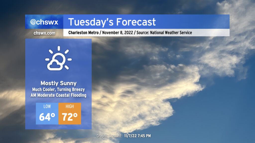
Election Day will feature rain-free conditions, plenty of sunshine, and much cooler temperatures as high pressure to the north wedges into the area. This will definitely feel a lot different than the mugginess we’ve had for the past week-plus. You’ll want to keep a jacket around, too, as winds become gusty as the pressure gradient between the high building in from the north and Subtropical Storm Nicole to the south intensifies. Watch for gusts upwards of 25 MPH away from the coast, with gusts 30-35 MPH possible at the beaches.
The last total lunar eclipse of 2023 — and last one visible from the US until 2025 — will peak tomorrow morning just before 6am. The moon will be getting lower on the horizon in the western sky, but cloud cover should be sparse for eclipse viewing.
The full moon will also be a contributor to elevated water levels in Charleston Harbor with the 7:31 AM high tide, which is expected to peak around 7.6′, producing minor to moderate coastal flooding. This may have some impacts on the morning commute for folks traveling around downtown Charleston. Be ready to use alternate routes in case you encounter flooded or closed roads.
Mariners should take note that a Tropical Storm Warning has been hoisted for the coastal waters (not the harbor, yet) with very rough marine conditions expected to develop due to the aforementioned pressure gradient. There are no land-based tropical headlines as of this writing.
Rest of the work week: Subtropical Storm Nicole to affect the area

The rest of the work week will be punctuated by impacts from Subtropical Storm Nicole, which is expected to turn north and northeastward by Thursday, strafing the coast Friday before improving weather sets in for Saturday.
Wednesday: Even cooler, with significant salt water flooding possible in the morning
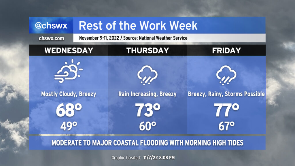
Wednesday will be a continuation of Tuesday’s breezy conditions, especially at the coast, as persistent northeasterly winds continue with Nicole to the south and high pressure wedging in from the north. Cloud cover will increase ahead of Nicole with some sunshine peeking through at times. It’ll be fairly chilly by recent standards (though closer to normal by early November standards) with highs topping out in the upper 60s.
Moderate to major coastal flooding (water levels 7.8-8.0′ MLLW) is expected a few hours around the 8:11 AM high tide. This could have significant commute impacts for those of you traveling into or around downtown Charleston with scattered to numerous road closures possible. This should also be enough water to close parts of Long Point Road near Snee Farm in Mt. Pleasant. Another round of moderate coastal flooding is in the forecast for the 8:30 PM high tide, which may scatter a few more road closures.
Thursday: Rain chances increase, turning warmer, major coastal flooding
We’ll see rain chances head up during the day Thursday as the high pressure wedge breaks down and warm and moist air surges inland. Temperatures will respond well with highs running about 5° warmer than Wednesday. Rain could be heavy at times, particularly near the coast. Winds will continue to gust around 25 MPH away from the coast, where gusts could approach 35-40 MPH. Surf and rip current hazards will continue.
Most notably, major coastal flooding is forecasted for Thursday morning. The current water level forecast is for an 8.4′ high tide to peak around 8:50 AM. This would be the highest since November 7, 2021, when water levels in the harbor peaked at 8.51′ with the morning high tide. We’ll obviously want to watch the onset of heavy rain on Thursday morning for the potential for prolonged flooding.
Rain should be in the area Thursday evening when water levels return to moderate flood stage with high tide around 9:11 PM. We’ll obviously want to watch this closely as well for additional flooding in downtown Charleston a few hours around this tide.
Friday: Heavy rain expected, maybe a storm or two
Forecast details become a little more blurry on Friday as the exact track of Nicole will have some impacts on what we see Friday and Friday evening. Following the current NHC forecast track, Nicole is expected to track a little inland from the coast on Friday. This would promote a warmer day with highs in the mid-70s as well as, for a time, put us on the dirty side of the storm, which could further increase water levels in the harbor to moderate to major flood stage once again in the morning. There could be a window later Friday for a thunderstorm or two as well, with the risk of a tornado or two not totally off the table. A more offshore track will lessen these impacts, though.
Regardless of track, periods of heavy rain will remain possible, with some areas seeing another inch or two during the day Friday into Friday night. What remains to be seen is how long this rain hangs around — generally speaking, we should see rain begin to taper off overnight Friday into early Saturday morning. There is still some model disagreement over how fast Nicole will be moving at this point as it interacts with a trough digging in from the west. Stay tuned as details become refined.
Bottom line
- Nicole will be a nuisance, but right now, not expecting the level of impacts we saw with Ian.
- Be ready for several rounds of flooding in downtown Charleston starting with Tuesday morning’s high tide.
- Timing and position of the track become more important to the details in the forecast later Thursday into Friday.
- It’ll turn much cooler by Sunday. Fall will return!
Follow my Charleston Weather updates on Mastodon, Bluesky, Instagram, Facebook, or directly in a feed reader. Do you like what you see here? Please consider supporting my independent, hype-averse weather journalism and become a supporter on Patreon for a broader look at all things #chswx!