The week ahead: Turning much cooler mid-week
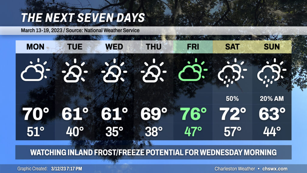
The main weather story for the week ahead will be a solid round of much cooler air affecting the area around mid-week. Some spots, generally inland of the coast, may run into trouble with some frost or freezing temperatures Tuesday night into Wednesday morning (and perhaps again Wednesday night into Thursday morning).
Sunday’s atmospheric malaise will clear the area overnight, and we’ll see clouds on the decrease during the day Monday. Highs should top out around 70° despite the surface front having moved by as the coldest air looks to be lagging behind. As we get later into Monday night, temperatures around 5,000 feet will drop below freezing and dewpoints at the surface will drop into the low 20s as north and northwest winds transport much drier air into the area. Consequently, we start Tuesday around 40°, and despite the sun’s best efforts, temperatures only top out slightly north of 60°.
Continued cool advection from the north will allow temperatures to fall into the mid-30s across the metro area overnight Tuesday into Wednesday morning. While it looks a little too windy to get much in the way of widespread frost, that doesn’t rule it out for inland and sheltered spots. Freezing temperatures will be possible well inland, perhaps into the far northwest corner of Berkeley County closest to I-95. If you’ve got sensitive vegetation, keep an eye out for possible frost and freeze headlines from the National Weather Service. Look for highs to once again struggle to reach the low 60s despite mostly sunny skies.
The core of the cold air lifts out of the area during the day Wednesday, and a warming trend commences Thursday. After starting in the upper 30s, we’ll top out near 70° on what should be another nice day across the area. The next front will be approaching the area Friday, and southerly winds will turn the heat pump back on, making for a St. Patrick’s Day in the mid-70s with increasing cloud cover (though rain looks to hold off).
Our next rain chance arrives with the cold front Saturday. We’ll peak early in the day in the 70s before the front moves by and chills us back out for Sunday. A stray shower may be possible Sunday morning, but the trend will be cooler and drier once more as highs only top out in the low 60s Sunday.
Follow my Charleston Weather updates on Mastodon, Bluesky, Instagram, Facebook, or directly in a feed reader. Do you like what you see here? Please consider supporting my independent, hype-averse weather journalism and become a supporter on Patreon for a broader look at all things #chswx!