Rest of the work week: Warming trend begins
A Freeze Warning is in effect tonight across the Charleston metro area. Protect sensitive plants and bring in your pets tonight. We should stay just above freezing closer to the coast, but some frost can’t be ruled out. Best bet is to err on the side of caution and go ahead and protect that vegetation.
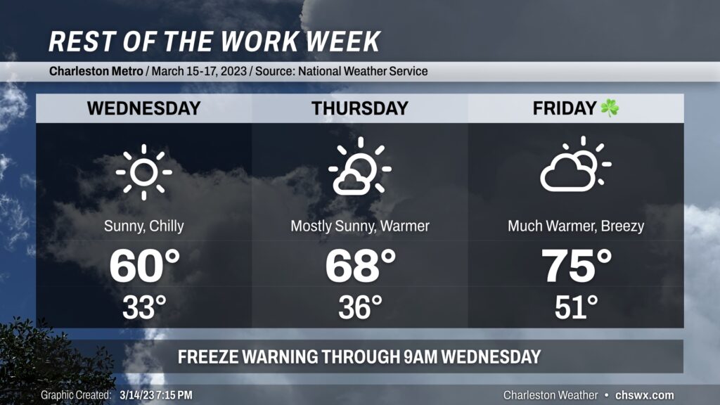
We have another bright and sunny day on Wednesday. It’ll be one more chilly day as temperatures start near freezing with wind chills in the upper 20s. Highs will struggle to 60° despite the full sunshine given lingering cool advection. You’ll want to keep a jacket around with that cool breeze. Winds will calm down Wednesday night into Thursday, and that could allow for some frost formation; we’ll need to see how far temperatures might fall. A Freeze Watch is in effect again for inland Berkeley and Dorchester for Wednesday night into Thursday morning as a result. Stay tuned for potential Frost Advisories or Freeze Warnings from the National Weather Service.
Thursday marks the beginning of a brief warming trend to close out the work week. After another chilly start in the mid-30s, temperatures will rise into the upper 60s as high pressure moves to our east and winds shift around to the south. We’ll see a few more clouds as a little more humid air begins to move in as well. Warming continues into Friday as a cold front approaches. The day starts around 50°, much warmer than we’ve seen for much of the week, followed by highs in the mid-70s as southwesterly winds pump warmer and more moist air into the area.
A prefrontal band of showers and maybe a thunderstorm will be approaching the area Friday night. Timing on the rain continues to be around and after midnight Friday into Saturday morning, so we should be getting much of St. Patrick’s Day in rain-free. However, if your revelry continues well into the night, you may want to consider some rain gear.
Cooler weather will return for the weekend, and we’ll get Sunday in rain-free, though with highs only in the 50s as cooler high pressure returns to the area.