Sunday’s forecast: A few afternoon storms possible
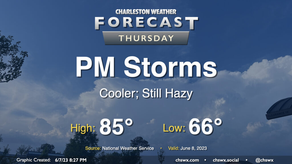
We have another warm day in store for Sunday, though with a better shot at an afternoon or evening thunderstorm. We start the day in the low 70s before warming into the upper 80s with a little more humidity than we saw on Saturday. (Hopefully a little less smoke, too.) Temperatures could feel a little warmer, generally around 90° or so, when factoring in the humidity.
With a little more available moisture, so it goes with instability. We could see the seabreeze get a little more active than it did on Saturday across the area, with scattered showers and thunderstorms possible in the afternoon and evening hours. Not everyone sees storms, so don’t cancel plans — just be ready to move indoors if a thunderstorm approaches.
Tropical update: Development looking likely in the Atlantic by midweek
The National Hurricane Center continues to watch an area in the Atlantic, now designated Invest 92L, for likely tropical development by the middle of next week. We don’t usually look to the east and central Atlantic for tropical development at this point in the year, but warmer-than-normal sea surface temperatures are making it happen.
Guidance generally continues it on a west to west-northwest track over the next few days, with wide spread toward the end of the models’ range as is expected with a storm that’s yet to really develop. There’s no imminent threat to the Lowcountry; I’ll let you know if that changes.
Follow my Charleston Weather updates on Mastodon, Bluesky, Instagram, Facebook, or directly in a feed reader. Do you like what you see here? Please consider supporting my independent, hype-averse weather journalism and become a supporter on Patreon for a broader look at all things #chswx!