Tuesday: Another warm day, but a little relief is inbound

Tuesday will be another rather warm day across the Lowcountry. After we topped out at 95° on Monday, temperatures should head a little higher on Tuesday, back into the mid-90s once again under partly cloudy skies. Peak heat indices will range from near 105° inland to around 108° closer to the coast where the higher-dewpoint air will be found. This is in the range where heat illness becomes an escalated concern, so be sure to take the normal heat precautions if you’re out and about Tuesday afternoon. Showers and thunderstorms are unlikely given ridging aloft, but a stray shower can never be totally ruled out.
Rest of the work week: An all-too-brief respite from humidity

A front will get through late Tuesday into early Wednesday, and we’re going to feel this one (in a good way). While a shower or two can’t be ruled out, the expectation is that the front makes a rain-free passage with just an uptick in cloud cover, and it will usher in an all-too-brief respite from the downright nasty humidity of the last month or two. We start Wednesday in the mid-70s, but as the cooler and drier air moves in, highs will only top out in the upper 80s. Dewpoints look projected to head down to the mid-60s (and perhaps dip even lower), which will be darn near refreshing. (For some context: We reached Wednesday’s NWS forecast high of 88° at 10am Monday.)
Mostly sunny skies continue through the rest of the work week as ridging dominates the weather pattern. Mid-60s dewpoints hang on for one more day on Thursday as temperatures start in the low 70s on the way to around 90° in the afternoon. We turn much warmer on Friday as winds go back around to the south and southwest, bringing dewpoints back to around 70° and air temperatures back to the mid-90s in the afternoon, though mostly sunny skies will generally prevail with the ridge remaining in place.
Tropical update: Still rather active
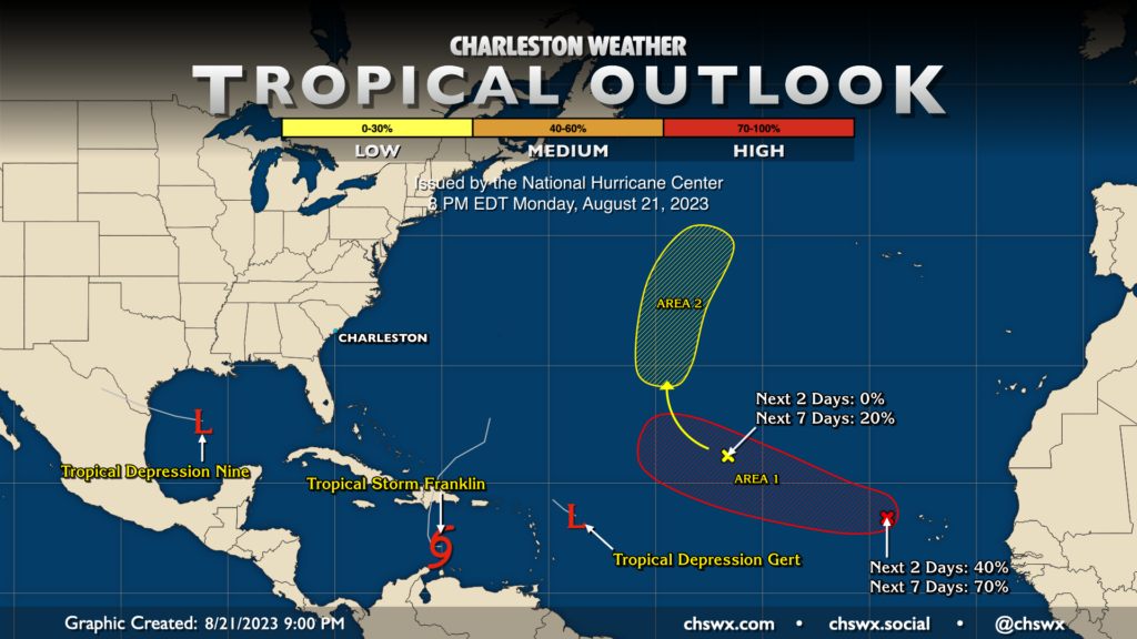
The tropical map remains very, very busy. Tropical Depression Nine was classified in the Gulf Monday evening, and it is expected to briefly become a tropical storm before making landfall in south Texas around midday Tuesday. Tropical Storm Franklin is stationary south of Hispaniola before it makes a turn toward the north on Tuesday; landfall as a tropical storm is expected Wednesday with flash flooding a major concern for the Dominican Republic and Haiti, while rain from Franklin will also impact Puerto Rico to a lesser extent. It is then expected to strengthen into a hurricane as it heads northward in the western Atlantic. None of these storms pose a threat to the Lowcountry.
There are two other areas that NHC is keeping an eye on: The first is a wave west of the Cabo Verde Islands that has a 70% chance of becoming a tropical cyclone, and the second is the remnant low of Tropical Storm Emily, which has a low chance of redeveloping as it moves northward through the central Atlantic. Both areas don’t pose any current risk to the Lowcountry.
Follow my Charleston Weather updates on Mastodon, Bluesky, Instagram, Facebook, or directly in a feed reader. Do you like what you see here? Please consider supporting my independent, hype-averse weather journalism and become a supporter on Patreon for a broader look at all things #chswx!