Tuesday’s forecast: Turning stormy in the afternoon as we finalize prep for Idalia

Tuesday will be another warm and muggy day as we prepare for Idalia’s arrival in the Lowcountry. We start the day in the mid-70s and warm to around 90° with heat indices approaching 100° within the increasingly tropical airmass. Showers and thunderstorms should begin to fire along the seabreeze in the afternoon and become somewhat numerous at times. Heavy rain capable of minor flooding will be possible. We’ll also need to watch the risk for coastal flooding in the evening, with minor to moderate flooding possible as water levels approaching 7.5′ with the 7:31 PM high tide. Due to the Storm Surge Watch in effect, there will be no Coastal Flood Advisory, so keep that in mind.
Idalia to be felt primarily Wednesday, with peak effects late Wednesday into Thursday morning
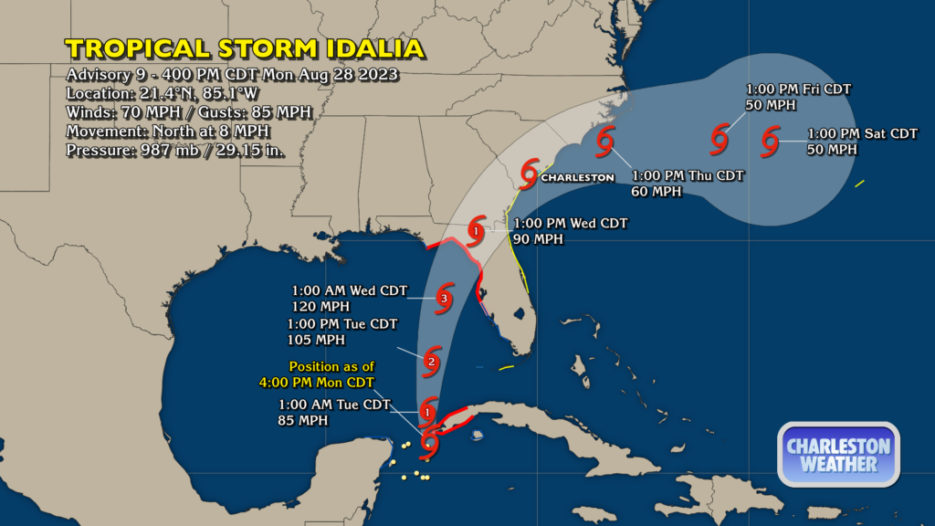
Idalia is on the cusp of hurricane strength as of this writing, with maximum winds of 70 MPH and gusts to 85. It’s currently moving toward the western tip of Cuba as it continues to move northward at 8 MPH. It should continue to pick up forward speed and organization as we get into Tuesday, and is forecast to strike Florida as a major hurricane, potentially strengthening right up to landfall. This is a very dangerous situation for the Big Bend of Florida, where a hurricane warning is in effect.
For our part, a Tropical Storm Watch is in effect for Berkeley and Charleston counties, and a Storm Surge watch is in effect for coastal areas of Charleston County. I expect these to be upgraded to warnings during the day Tuesday.
The forecast track for Idalia takes its center right along the South Carolina coast Wednesday evening through Thursday morning. Our peak effects should be later Wednesday into early Thursday, when the heaviest rain and strongest winds should occur. Here’s what we’re looking at:
- Rain: 4+” is a good bet for quite a few of us, with upwards of 8″ possible in isolated locations. It appears the rain threat will be highest to the north and west of the system as it interacts with a frontal zone. Freshwater flooding will be possible in some spots particularly where heavy rain bands repeat on themselves.
- Wind: The highest winds will be closer to the coast. Downtown should experience a period of tropical storm force gusts overnight Wednesday into early Thursday, while tropical storm force gusts are possible across the metro, especially east of 17-A.
- Flooding: Water levels approaching or exceeding 8′ are forecast Wednesday night as high tide will closely coincide with the center’s closest pass. It remains to be seen just how much they will coincide — the forward speed of the storm is still something that is being worked out based on the shifts in forecast track today — but this could be a decent storm surge event for our area provided the center doesn’t move north of the area before high tide. The NHC forecast is generally between 2-4′ of inundation in tidal areas. This doesn’t take into account any freshwater flooding from heavy rain, either, which may be a contributor as well.
- Tornadoes: Tornadoes within rain bands on the north side of the system will be possible later Wednesday into early Thursday morning. Tropical tornadoes are notoriously difficult to detect and warn on, and can come up on you quickly. Make sure you have multiple ways to receive weather alerts — your smartphone is good, but is one tool — including one that doesn’t require the Internet, such as a weather radio, which can wake you if a warning is issued.
It gets better, though

Idalia will gradually depart during the day Thursday, with lingering showers and some gusty winds in its wake, though both will slacken off throughout the day. Thursday will be probably one of the cooler days we’ve had in recent memory, with a high only around 81°. Cooler and drier air continues to infiltrate into the area for Friday, and we could see a really tremendous day of weather with highs topping out once again in the low 80s with reasonably low humidity — a perfect way to ring in meteorological fall, which starts September 1.
What you should do tonight and tomorrow
Here’s what you can get done tonight and tomorrow ahead of Idalia. Depending on the forward speed of the storm, you may have a few extra hours early Wednesday, but once winds start to kick up, that’ll be it.
- Bring in loose items from outside, especially if you are living closer to the coast, where the greatest risk of tropical storm conditions will reside.
- Sandbag and/or deploy other flood resistance tools if you are in a flood-prone area.
- Check your flashlights and batteries. Make sure your weather radio is receiving properly from the Awendaw tower at 162.550 MHz or the Cross tower at 162.475 MHz, too.
- Power up any charging bricks you may have. Always be charging in case of a power outage!
Approaching tropical cyclones can be a scary thing, but the good news is that we have got this — this is far from anything we can’t handle, and we’ll come out of this just fine, especially if we’re prepared. Stay tuned to reputable weather sources as the forecast continues to be fine-tuned over the next day.
Follow my Charleston Weather updates on Mastodon, Bluesky, Instagram, Facebook, or directly in a feed reader. Do you like what you see here? Please consider supporting my independent, hype-averse weather journalism and become a supporter on Patreon for a broader look at all things #chswx!