Rest of the work week: Back to warm
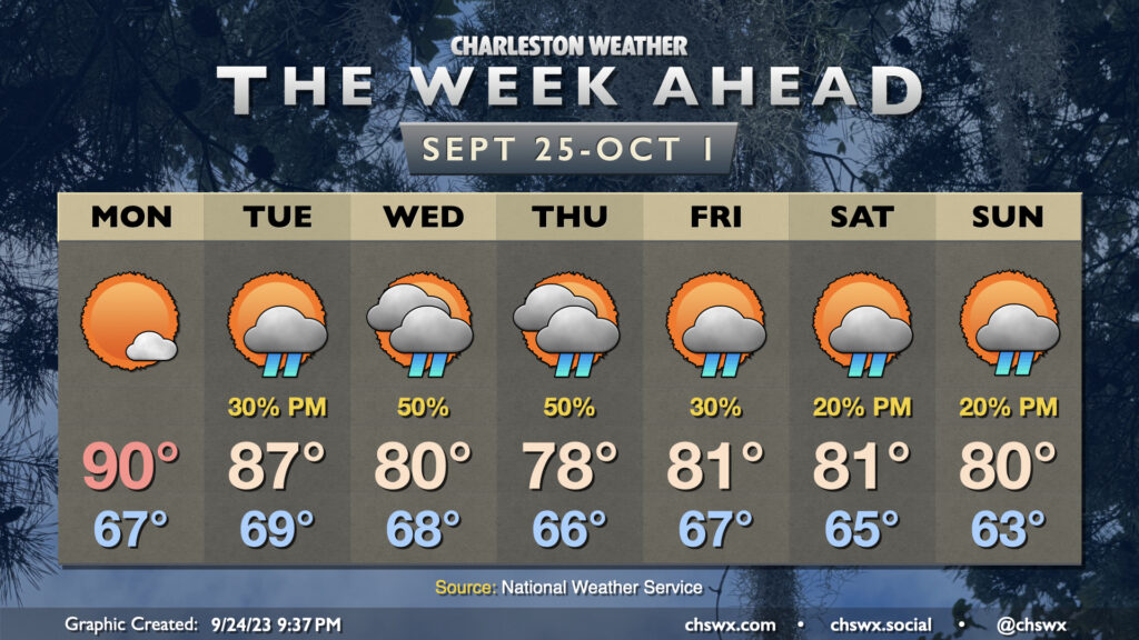
Plenty of sunshine is in the offing for the rest of the work week as high pressure remains the primary driving force for our weather. Temperatures climbed back into the low 90s on Labor Day, and this will continue as we head into the rest of the week, with mid-90s expected by mid-week. Dewpoints in the mid-60s will keep heat indices in the mid-90s on Tuesday, but as dewpoints creep up throughout the week, so it shall be with the heat index as well. Feels-like temperatures will be flirting with 100° again starting Wednesday through the rest of the week.
There’s not much in the way of rainfall to report on for much of the week with high pressure in control, but we start to see some cracks in the armor on Friday as a few storms should pop on the seabreeze, with slightly better coverage of showers and storms each afternoon this weekend.
Tropical update: No imminent concerns this week, but a storm to watch is starting up in the Atlantic
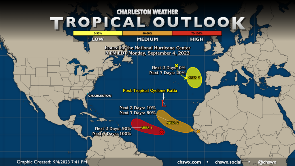
The Atlantic basin remains rather busy, but beyond Idalia there’s not been much to be concerned about. There are four areas of interest in the Atlantic; the first, post-tropical cyclone Katia, has had its last NHC advisory. The disturbance formerly known as Franklin has a small chance of kicking back up off Portugal later this week, while a disturbance emerging from Africa has a solid chance — 60% — to develop as the week goes on.
The area to watch, though, is in the Central Atlantic and is almost certain to develop in the next day or so. It has been tagged as 95L by the National Hurricane Center, and is likely to develop into a hurricane this week. It’s early days as far as where it will go, but it could have eyes on the Leeward Islands as we approach the second half of the week. From there, it’s fairly unclear as to where it will go. So far, there is decent ensemble support for it to find an escape route out to sea, but that is pretty far off at this point — it’s just too early to know exactly what it’s going to do. The good news is that we have plenty of time to watch it, and there is no current imminent threat to the Lowcountry.
Follow my Charleston Weather updates on Mastodon, Bluesky, Instagram, Facebook, or directly in a feed reader. Do you like what you see here? Please consider supporting my independent, hype-averse weather journalism and become a supporter on Patreon for a broader look at all things #chswx!