Thursday: Scattered showers with breezy conditions as low pressure develops offshore

Rain-free conditions come to an end Thursday as we should see some scattered showers from time to time courtesy of developing low pressure well offshore. We’ll get off to a much warmer start than the previous couple days, with lows across the metro in the upper 60s to around 70°. Expect a scattering of showers and maybe some rumbles of thunder throughout the day, coming ashore within onshore flow. A few heavy downpours can’t be ruled out. Highs top out in the low 80s.
We’ll get close to coastal flood stage with Thursday afternoon’s high tide, forecast to peak around 12:41 PM, thanks to the increasing northeasterly flow, which tends to pile water up quite efficiently, so we’ll need to keep an eye on that in case some salt water works into the area.
Friday & the weekend: Unsettled at times with a few rough beach days

The developing low will continue to keep showers in the forecast for Friday and into Saturday. Some cooler temperatures will result, as well, especially as winds go more northerly and then northwesterly heading into Saturday. Highs on Friday and Saturday top out around 80° with the risk for showers continuing. The aforementioned windy conditions will be pronounced at the beaches, and may cause some erosion, high surf, and rip currents. We’ll also need to watch for minor to moderate coastal flooding with Friday afternoon’s high tide. Suffice to say, it doesn’t look like the best beach weekend.
We see improvement on Sunday as the low lifts away. Clouds scour out, and we have a fairly nice day on tap with lows in the mid-60s and highs in the mid-80s under mostly sunny skies. Winds will be diminishing some by Sunday as well.
Tropics: Subtropical development possible off our coast
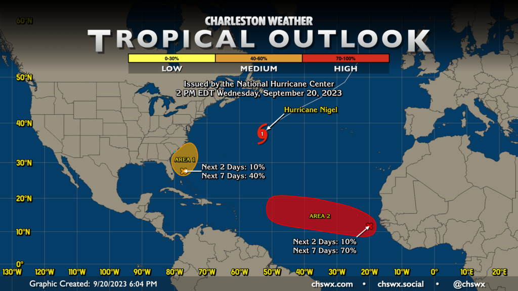
The area of low pressure that will be driving the weather conversation over the next few days could still take on some tropical characteristics as it moves northward over the weekend. NHC has upgraded to a medium chance of this happening (40%). Regardless of tropical development, our impacts remain unchanged on land — this would be mostly a marine issue.
Elsewhere in the tropics, Nigel continues to move northeastward as it gradually transitions to an extratropical cyclone. Finally, a wave has emerged off the African west coast today, and has a 70% chance to develop into a tropical cyclone over the next week as it moves WNW across the eastern Atlantic. It’s way out there, and is currently not a concern for us here in the Lowcountry.
Follow my Charleston Weather updates on Mastodon, Bluesky, Instagram, Facebook, or directly in a feed reader. Do you like what you see here? Please consider supporting my independent, hype-averse weather journalism and become a supporter on Patreon for a broader look at all things #chswx!