The week ahead: A brief return to 90° before cooling back off (and turning unsettled)
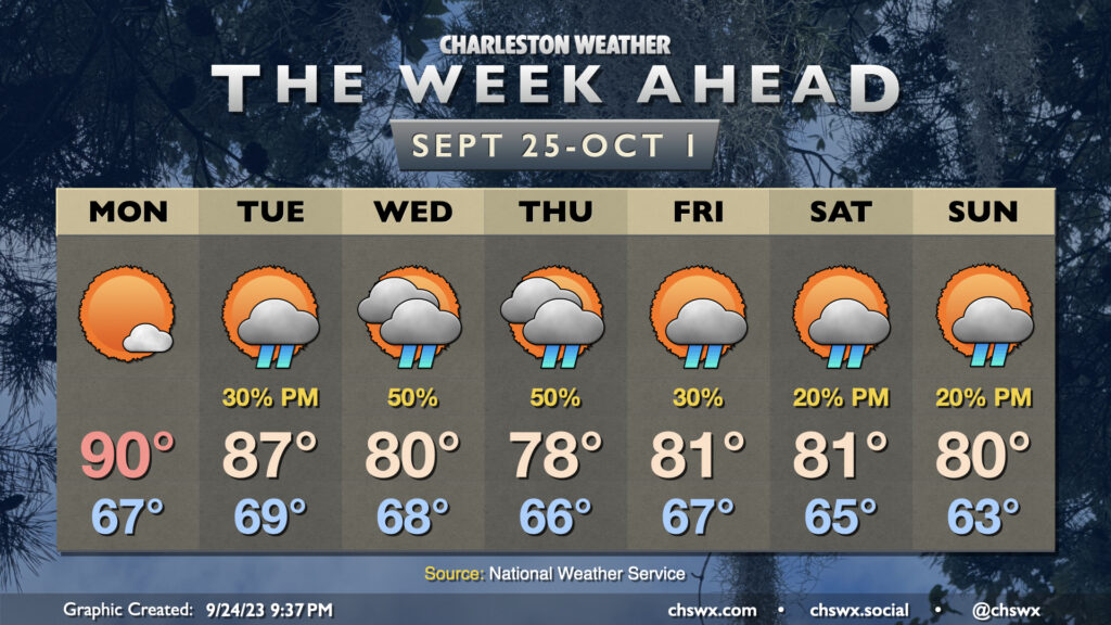
We may be past the autumnal equinox, but Monday clearly looks to have missed the memo as it brings back a bit of summer before temperatures fall back below normal later this week. Dry air will keep skies mostly clear, and a bit of shortwave ridging will help highs top out around 90° in the afternoon after starting the day in the upper 60s to around 70° at the coast. From there, though, changes will be afoot as high pressure anchored in New England starts to wedge into the area beginning Tuesday. This will drive high temperatures from the mid-80s on Tuesday to the low 80s by Wednesday, with below-normal highs lasting into the weekend. A trough developing offshore will help keep shower chances in play for much of the week, primarily in the afternoons, though it’s worth noting that we’ll likely get some sunshine in as well at times. Northeasterly winds will turn breezy as we head into the second part of the week, and this could drive some coastal flooding concerns through the weekend. Some of the guidance is spitting out some fairly high tides, but it’s also worth noting that this guidance isn’t really that awesome and often goes to extremes. Keep an ear out for Coastal Flood Advisories from the National Weather Service.
Tropics: Philippe to encounter wind shear; a couple areas of note, including one in the Gulf
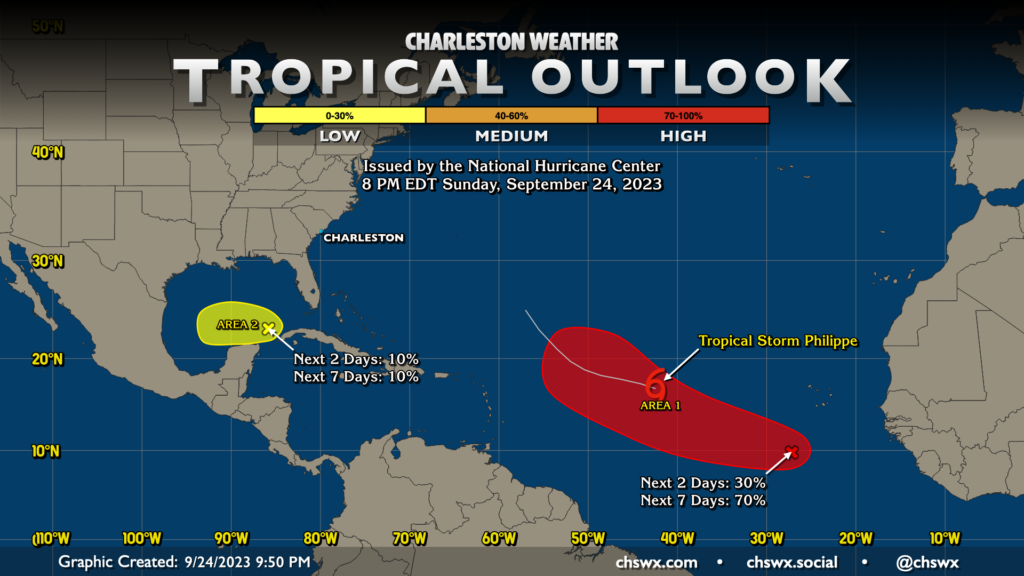
The tropical outlook is largely quiet as far as concerns for our neck of the woods as of this evening. Tropical Storm Philippe is churning in the central Atlantic, forecast to struggle with wind shear despite fairly warm water otherwise. This will keep it capped at tropical storm strength for at least the next few days. It still appears, though, that Philippe is not going to be a major concern for land at this point (with the possible exception of Bermuda way down the line).
A wave south of the Cabo Verde Islands is the next area that’s likely to become a depression in the next week, with the National Hurricane Center giving it about a 70% chance to develop. It should follow in Philippe’s footsteps track-wise, and doesn’t appear concerning for our neck of the woods at this point.
A second area of interest in the Gulf of Mexico has a brief window to possibly develop a little further over the next few days, but shear will become fairly hostile here later this week and should shut down any large-scale tropical development. Even so, it’ll trend generally westward and stay well away from here. Overall, not a bad place to be as we close out September and head into the final two months of the season. (It’ll be over before you know it!)
Follow my Charleston Weather updates on Mastodon, Bluesky, Instagram, Facebook, or directly in a feed reader. Do you like what you see here? Please consider supporting my independent, hype-averse weather journalism and become a supporter on Patreon for a broader look at all things #chswx!