Tuesday: One more unseasonably warm day with a few showers
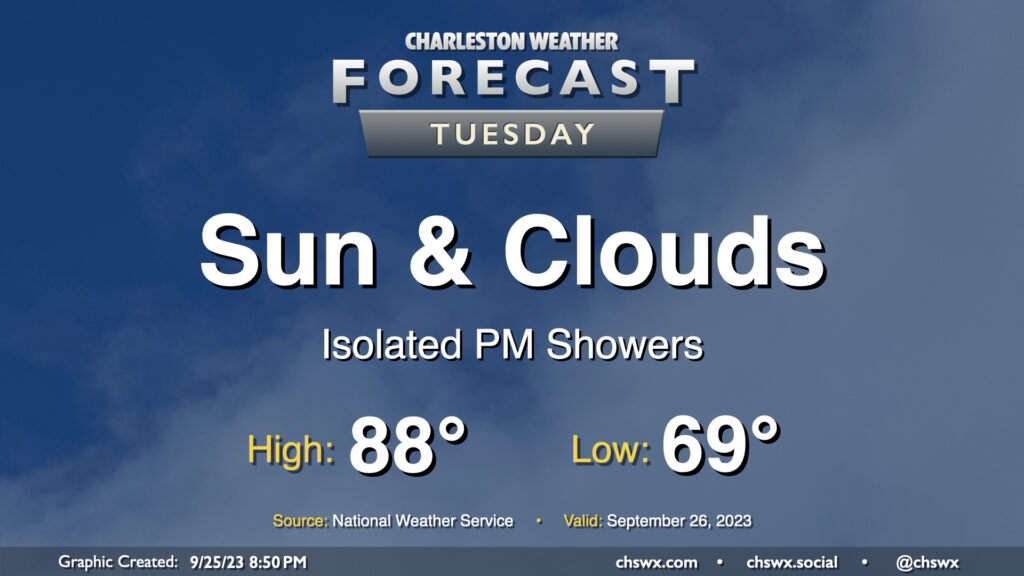
We have one more day of the upper 80s in store before changes arrive in the form of a wedge of high pressure building in from the northeast for the rest of the week. Tuesday starts in the upper 60s inland to perhaps mid-to-upper 70s closer to the coast. Highs then head into the upper 80s once more, and with dewpoints edging up into the upper 60s, it’ll feel closer to 90° or so. From there, clouds will increase and a few showers should break out in the afternoon, though nothing over-the-top is really expected. There may be a rumble of thunder late, but overall, not expecting much in the way of lightning. Shower chances continue into the evening, and really for much of the rest of the work week from there.
Rest of the work week: Scattered showers, but much cooler
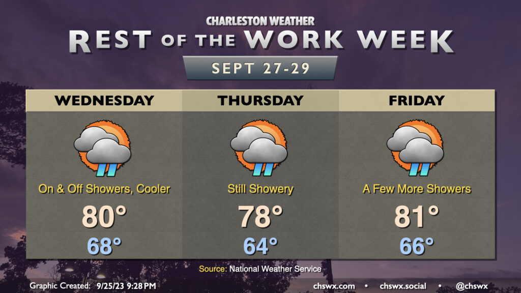
The rest of the work week will run much cooler as high pressure wedges southward into the area. This will turn winds to the northeast and send temperatures back to much more seasonable values for late September. Expect highs to generally range between the upper 70s to low 80s each afternoon through Friday, with the potential for some showers each day as a coastal trough hangs around nearby. The trough should start to move away later Friday, and that will begin to taper the rain chance with it. Rain should generally be light, though a few pockets of heavier downpours can’t be ruled out particularly Wednesday and Thursday. It won’t rain all day at any one location, either.
Coastal flooding threat increasing; major coastal flooding possible Wednesday and Thursday evenings
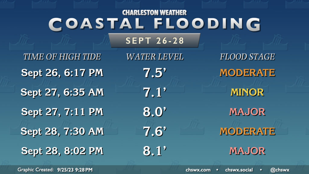
Typically speaking, high pressure wedging southward and winds turning northeast are a good bet to elevate the risk for coastal flooding, and this week will be no exception, especially as astronomical effects from the upcoming full moon contribute as well. Expect coastal flooding at times of high tide beginning Tuesday evening, when a round of moderate flooding is possible a couple hours around the 6:17 PM high tide. This tide could have some commute disruptions especially for folks leaving downtown to head into West Ashley along 17 and 61. After a round of minor flooding Wednesday morning, water levels look to peak even higher — around 8′ or so — around the 7:11 PM high tide, which may yet impact at least the tail end of the evening commute. Moderate flooding could impact Thursday morning’s commute, and Thursday evening’s high tide could head even higher, once again hitting major flood stage at 8.1′. It’s likely these elevated tides will continue into Friday and the weekend as well as astronomical predictions remain well into king tide territory, and with northeasterly winds expected to continue, we could see another couple rounds of moderate or even major flooding. Stay tuned to forecast updates and potential Coastal Flood Watches and Warnings from the National Weather Service.
Tropics: Philippe battles shear; next depression looks likely this week

Tropical Storm Philippe continues to struggle against wind shear in the central Atlantic, and looks to do that for the next several days as it is forecast to remain generally a weak tropical storm moving safely to the north of the Lesser Antilles. An interesting wrinkle with this forecast is that the weaker storm may have a harder time feeling the tug to recurve northward; NHC notes this in its forecast and actually turns it a little more west by this weekend. However, the shear should remain an issue and keep it on the weak side, and guidance down the road seems to suggest it will shear apart before it gets too close for comfort. There’s plenty of time to watch Philippe as it treks across the Atlantic, and right now it doesn’t appear to be much we need to be worried about.
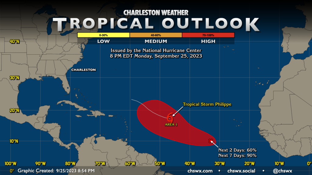
The only other area of interest in the Atlantic is a wave to the southwest of the Cabo Verde Islands (tagged as Invest 91L) that looks to become our next depression sometime this week. It should have a little easier time with shear, and it’s quite probable it will get a name. The next name on the list is Rina. Indications are that it will recurve well before it threatens any land (especially as it should miss out on the shear that is weakening Philippe, helping it intensify and becoming more responsive to weaknesses in the steering flow), but we’ll keep an eye on it.
Follow my Charleston Weather updates on Mastodon, Bluesky, Instagram, Facebook, or directly in a feed reader. Do you like what you see here? Please consider supporting my independent, hype-averse weather journalism and become a supporter on Patreon for a broader look at all things #chswx!