Tuesday’s forecast: Stretch of brilliant weather continues
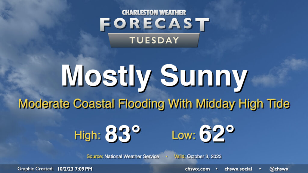
Our solid start to October continues on Tuesday, with mostly sunny skies and comfortable temperatures continuing with high pressure in control. The only potential issue will be the risk for moderate coastal flooding with high tide just before noon; there could be travel disruptions as some of y’all look to grab lunch, so that’ll be something to keep an eye on. Otherwise, though, it’ll be another very nice day.
Rest of the work week: Slight storm chances return Thursday and Friday, but still pretty solid otherwise
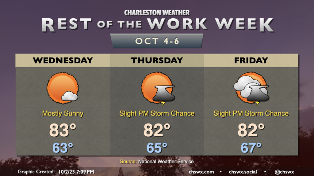
We’ll keep the great weather going into Wednesday, with just a few clouds and continued comfortable temperatures. We start Wednesday in the low 60s and warm into the low to mid-80s in the afternoon — quite far from any semblance of shabbiness. We’ll start to see a little more moisture return to the picture beginning Thursday into Friday as a cold front approaches, but shower and storm chances remain rather low. Many of you may not see any rain at all.
The aforementioned front gets through Saturday, and by Sunday morning, we’ll be waking up to a much more fall-like airmass, with mid-to-upper 50s common across the area only warming into the mid-70s in the afternoon. Not ready to go with a full-blown Sweater Weather Watch just yet, but we’re making progress in that direction.
Coastal flooding threat continues into Thursday
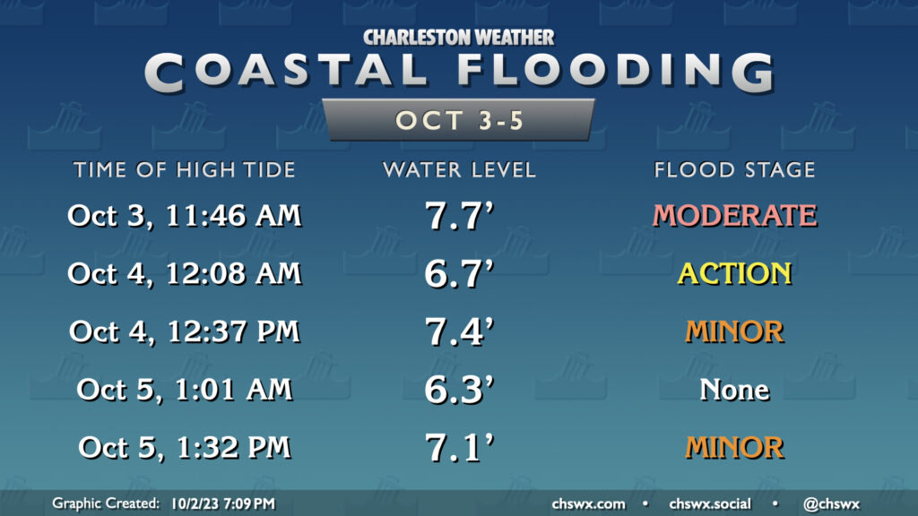
The risk for coastal flooding will continue with each daytime high tide through Thursday, though it will be gradually waning as we get further from the full moon and winds begin to turn a little more unfavorable, especially closer to the end of the week as a front approaches. Still, moderate flooding may cause issues with the midday Tuesday high tide, and minor to moderate flooding will be problematic for some of us on Wednesday as well. Thursday afternoon’s high tide will top out a little over 7′, producing generally minor flooding. Stay alert to Coastal Flood Advisories from the National Weather Service over the next few days.
Tropics: Philippe affecting the Leeward Islands
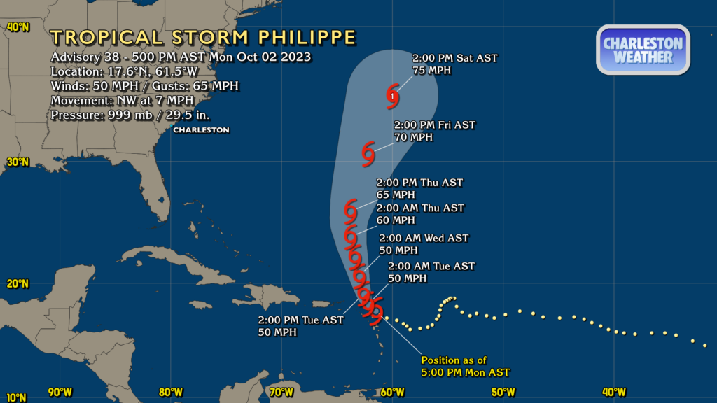
Tropical Storm Philippe is the only game in town in the Atlantic basin right now as it affects the northern Leeward Islands over the next day or so. Philippe is holding its own as a 50 MPH tropical storm, and it will maintain that strength heading into Wednesday before shear relaxes. From there, strengthening is forecast, and it may yet reach hurricane strength over the weekend as it begins to accelerate north-northeast. It might give Bermuda a somewhat close shave as it recurves, but it should otherwise pose no further threat to land.
Otherwise, the Atlantic remains quiet, and there are no tropical concerns for the Lowcountry for the foreseeable future. Just under two months to go in the season…not that we’re counting or anything.
Follow my Charleston Weather updates on Mastodon, Bluesky, Instagram, Facebook, or directly in a feed reader. Do you like what you see here? Please consider supporting my independent, hype-averse weather journalism and become a supporter on Patreon for a broader look at all things #chswx!