Tuesday: Chilly day with decreasing cloud cover; Freeze Watch for Wednesday morning
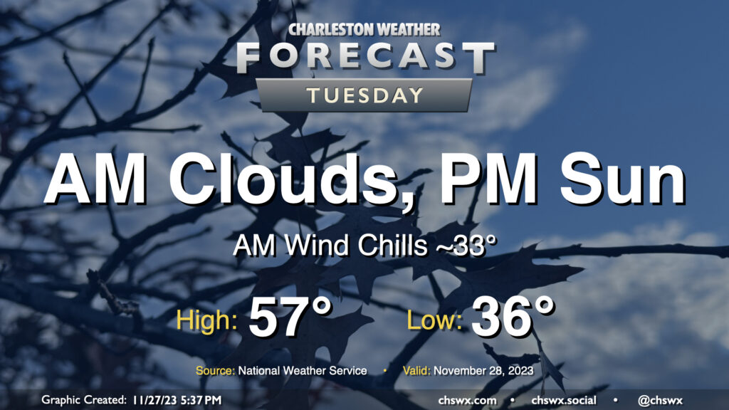
Tuesday will begin a string of a few chilly mornings across the metro area. Temperatures will start in the mid-30s; breezy northwest winds will make it feel closer to freezing, so bundle up accordingly. (There should be too much wind and too little moisture for frost formation, BTW.) Cloud cover will hang around for the morning before scouring out in the afternoon. Even so, highs will struggle to the mid-to-upper 50s as northerly winds continue to blow cold air into the region.
There will be a chance for a little salt water to creep up out of some drains around Lockwood as well as out of Gadsden Creek with Tuesday morning’s high tide, though it should peak just shy of coastal flood criteria. Still, you don’t want to drive through salt water if you can help it. High tide on Tuesday morning is expected to peak around 8:17am.
Rest of the work week: Frost and freeze concerns Wednesday and Thursday; showers return Friday
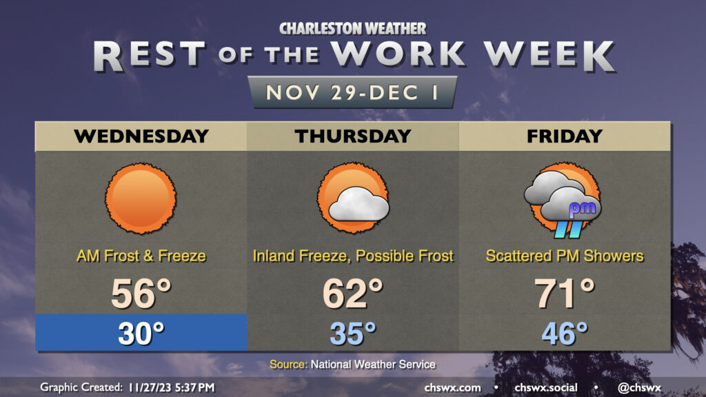
A Freeze Watch is in effect for Wednesday morning as freezing temperatures are expected away from the immediate coast. Lows in the Charleston metro will dip to around 30°, with even cooler temperatures possible further inland. Be ready to bring sensitive plants indoors as this could be a fairly long-duration freeze, particularly inland of 17-A. Patchy frost will be possible as well as winds will be much calmer Tuesday night and Wednesday morning than the previous day. It certainly looks that if this verifies, that will bring the growing season to an end, and as a result, no more frost and freeze alerts will be issued until March. Temperatures will warm to the mid-50s in the afternoon under full sunshine. Definitely a sweater weather day if I ever saw one!
Thursday could once again start out with some freezing temperatures well inland and patchy frost elsewhere as lows bottom out in the low-to-mid-30s in the metro, with low 30s further inland. A warming trend will begin Thursday afternoon, though, as highs top out in the low 60s thanks to high pressure slipping offshore. We’ll see a few more clouds as well, but there will still be plenty of sun. By Friday, we’re back in the 70s, but at the price of increased moisture and disturbances aloft interacting to bring some scattered showers to the area in the afternoon and evening. Shower chances look to persist through the weekend into the beginning of next week, too.
Follow my Charleston Weather updates on Mastodon, Bluesky, Instagram, Facebook, or directly in a feed reader. Do you like what you see here? Please consider supporting my independent, hype-averse weather journalism and become a supporter on Patreon for a broader look at all things #chswx!