Rest of the work week: Chilly couple days, then turning warmer Friday
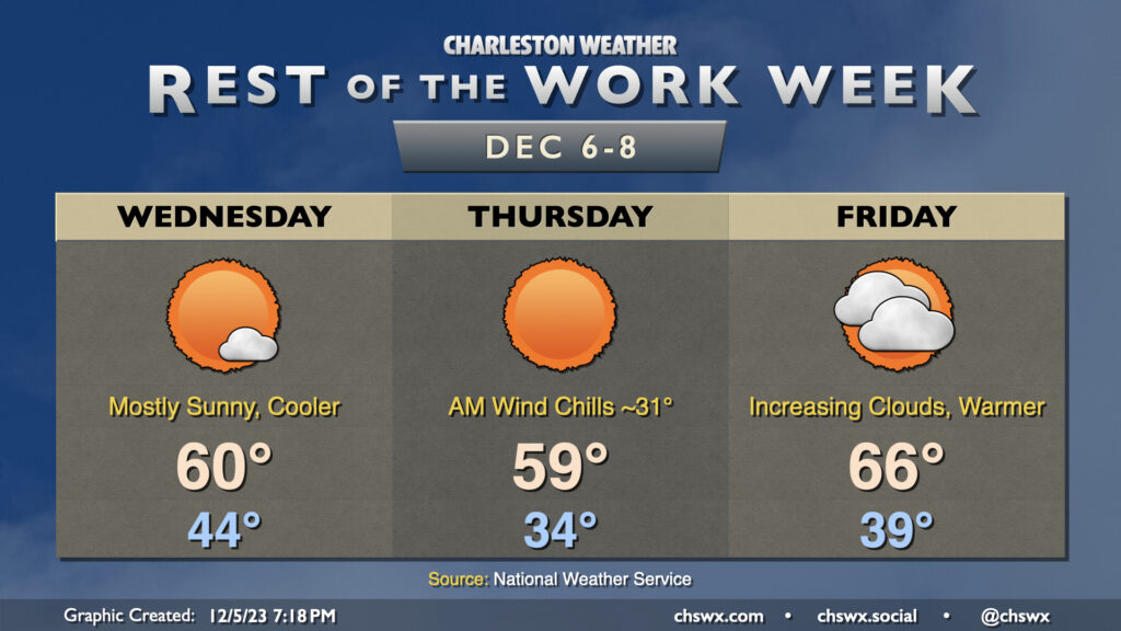
Another cool couple days lie ahead as a reinforcing front comes through early Wednesday morning. This will be a pretty solid shot of cool and dry air as high pressure builds in from the west. We’ll start Wednesday in the mid-40s, but the cooler air rushing in will limit the high to around 60° in the afternoon despite primarily sunny skies. It’ll be a bit breezy, with gusty winds out of the northwest at times, so some element of wind-breaking may be ideal.
Thursday will be the coolest day of the week. We’ll start the day in the mid-30s, with inland locations possibly approaching freezing. A light wind will make it feel a little cooler, with wind chills in the low 30s across the metro. Skies will once again be predominantly cloud-free, but the cold high pressure settling in will hold highs to the upper 50s to around 60°.
High pressure slips offshore Friday, and this allows some warmer air to move back in. We start Friday in the upper 30s to around 40°, but temperatures will warm back toward the mid-60s in the afternoon. Clouds will also be increasing as a coastal trough begins to take shape nearby, but rain is not expected.
Weekend outlook: Turning unsettled, particularly Sunday
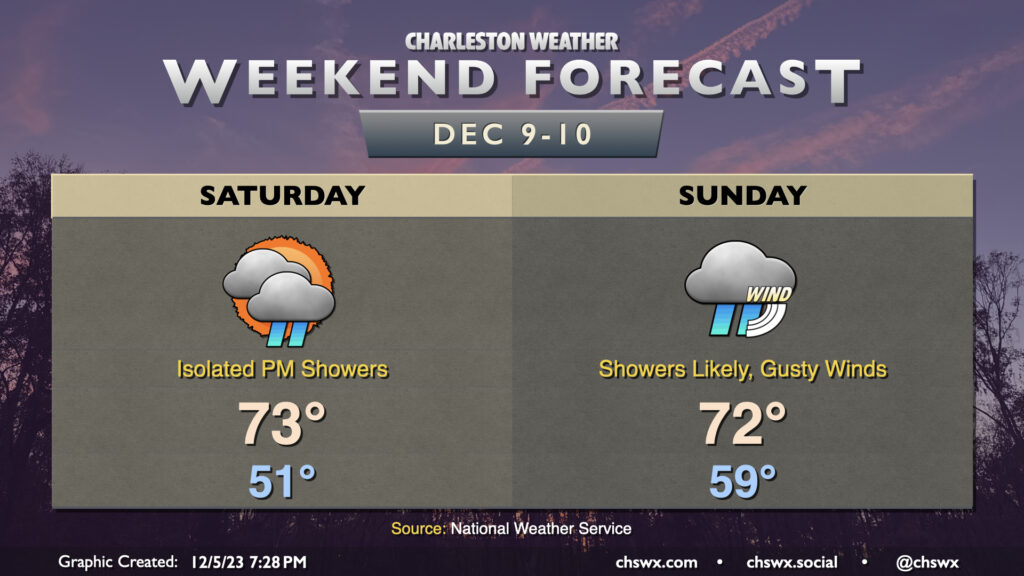
Remember how we started the year and could not catch a break with the weather on the weekend if our lives depended on it? I’m getting a familiar feeling with the past couple weekends. It looks like this feeling continues for this upcoming weekend as a highly dynamic storm system moves across the eastern half of the country. While it arrives in earnest on Sunday, we’ll get into the storm’s warm sector on Saturday as a coastal trough/warm front lifts across the area, bringing warm and moist air over the Lowcountry. This will send highs to the mid-70s in the afternoon with increasing cloud cover, and a few showers can’t be totally ruled out, but the risk for showers appears relatively low.
Sunday will be another unseasonably warm and muggy day ahead of the storm system’s cold front. We’ll start the day around 60°, with highs heading into the low 70s. Southwest winds ahead of the front will become increasingly gusty as a 40 to 50-knot low level jet moves across the Carolinas and Mid-Atlantic states. Scattered showers will be possible in the morning followed by what should be a band of showers and maybe a thunderstorm or two moving across the area in the afternoon and evening hours with locally heavy rain possible. There will be plenty of shear available, but instability will, as is often the case in the cool season, be the limiting factor. Some gusty winds could be possible in the strongest storms, but right now any severe weather threat appears very limited. Keep an eye on forecast updates as we head into the weekend for updates on timing and intensity as the details get worked out.
The front gets by sometime later Sunday evening into early Monday morning, and from there, temperatures will cool back below normal as we head into next week.
Follow my Charleston Weather updates on Mastodon, Bluesky, Instagram, Facebook, or directly in a feed reader. Do you like what you see here? Please consider supporting my independent, hype-averse weather journalism and become a supporter on Patreon for a broader look at all things #chswx!