Sharp cooldown incoming for Wednesday & Thursday morning; hard freeze this weekend
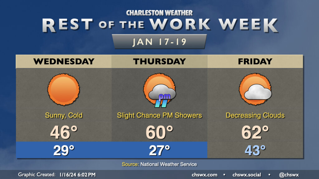
A rather cold day awaits on Wednesday despite full sunshine throughout the day as chilly high pressure builds into the area. Temperatures should fall to the upper 20s in the metro area early Wednesday morning as cold air blows in. Wind chills will bottom out in the low 20s, so be sure to dress accordingly as you head out to work or school. Afternoon highs will struggle to the mid-40s as cold air continues to settle into the area throughout the day. Despite light rain during the day Tuesday, black ice doesn’t look like it will be a factor given that we’ll be drying out very quickly tonight as dewpoints plummet into the 20s.
We’ll dip a little further into the 20s overnight Wednesday into Thursday morning. Temperatures should reach freezing by late evening, and should stay there through sunrise, with roughly an 8-10 hour period of freezing temperatures a decent possibility. It’ll be a good idea to keep a faucet on a drip, make sure pets are in a warm place, and ensure plants are protected. The good news is that the freeze will quickly give way to warmer temperatures Thursday afternoon, with highs expected to peak around 60°. A few showers will be possible in the late afternoon into the evening hours, but very little overall rainfall is expected.
Friday will be the only day in the next few that’ll start above freezing; expect lows in the low 40s in the morning, followed by highs in the low 60s in the afternoon. A cold front will advance through the area roughly midday or so, but the coldest air will be delayed a little bit. Still, expect clouds to scour out as drier air moves in.
Weekend forecast: Brrr
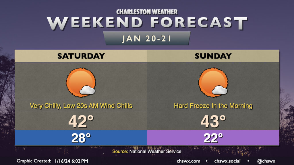
At the risk of understatement, we turn rather cold this weekend in the wake of Friday’s front. We start Saturday in the upper 20s with wind chills once again likely dipping into the low 20s. From there, we don’t warm very much — expect highs to only peak in the low 40s, a significant departure from normal highs (generally around 60°) and even colder than we’ll see Wednesday.
The most dangerous freeze in this cold snap arrives Saturday night through Sunday, with 10-12 hours of freezing temperatures expected across the area. Air temperatures will fall into the low 20s in much of the metro area — Downtown included — which is well into pipe-busting territory for this part of the world. Cold weather precautions will be a must. Warming shelters will be open; refer to your local municipality or county for where those shelters will be in case you or someone you know will need a warm place to be. Highs on Sunday will head above freezing, but only into the low 40s. After one more start in the 20s on Monday, a warming trend commences and should have some staying power — we’re back in the 60s by Tuesday.
Follow my Charleston Weather updates on Mastodon, Bluesky, Instagram, Facebook, or directly in a feed reader. Do you like what you see here? Please consider supporting my independent, hype-averse weather journalism and become a supporter on Patreon for a broader look at all things #chswx!