Thursday’s forecast: Frigid start, but warming — albeit briefly
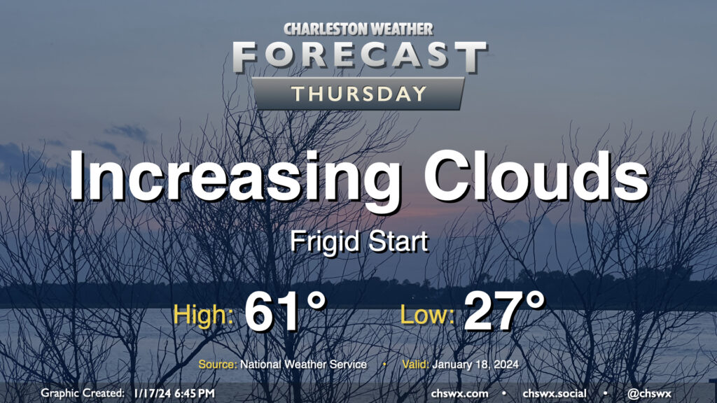
Thursday will get off to a very chilly start across the Lowcountry as calm winds and clear skies combine to allow for a solid radiational freeze across the area tonight into Thursday morning. Expect lows to bottom out in the mid-20s in a fair bit of the metro, with slightly warmer — but still at or very near freezing — temperatures near the coast. Bring pets in tonight and cover sensitive plants. Consider dripping a faucet, too, especially further inland.
The good news is that temperatures won’t stay below freezing for long after the sun comes up. High pressure will move offshore, allowing temperatures to recover to the low 60s by afternoon as cloud cover increases. There is a risk for a few showers very late Thursday into early Friday, but we’ll get the daytime hours in rain-free.
Friday & the weekend: Brief respite from the cold ends abruptly Saturday; dangerous cold possible overnight Saturday into Sunday
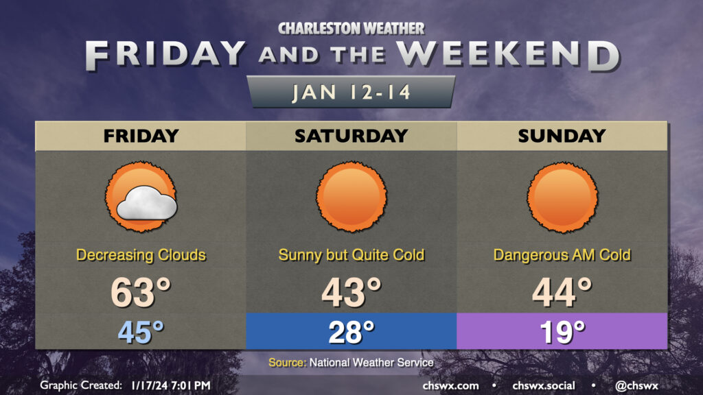
Showers should be out of our hair before daybreak Friday. Clouds will be decreasing as drier air moves in behind the front. We should still see high temperatures peak in the low 60s, but that looks to be early in the afternoon as we start to really cool off by early evening. In fact, we should be in the 40s by 7PM. By Saturday morning, air temperatures are in the upper 20s, but the wind will make it feel closer to the upper teens/low 20s. If you’ve got an early morning run or need to be somewhere, take appropriate precautions against the very low wind chills. You’ll want to exercise cold weather precautions for pipes, plants, and pets as well Friday night. Ongoing cold advection will keep Saturday’s highs pinned to the low-to-mid-40s despite full sunshine.
The most dangerous cold arrives overnight Saturday into Sunday morning. Air temperatures should fall into the upper teens across much of the metro area, with wind chills dropping into the low teens and maybe into the single digits in some spots, especially the further inland you go. This will probably prompt a rare Wind Chill Advisory if trends continue. Cold weather precautions will once again be a must, with a pipe on drip, plants covered or indoors, and pets safely in a warm place. Check on elderly and otherwise vulnerable folks, as well.
Temperatures on Sunday will warm to the mid-40s under full sunshine once again. We’ll at least get above freezing, but it will be another very cold day across the Lowcountry.
Cold weather precautions will be needed again overnight Sunday into Monday morning, but that will be it as far as freezing mornings go — in fact, we might be back in the 70s by Wednesday. Hold on tight to the railing and make sure you’re buckled in as we continue to ride on the temperature rollercoaster…
Follow my Charleston Weather updates on Mastodon, Bluesky, Instagram, Facebook, or directly in a feed reader. Do you like what you see here? Please consider supporting my independent, hype-averse weather journalism and become a supporter on Patreon for a broader look at all things #chswx!