Tuesday: Clouds and rain are gone, but chill and wind remain
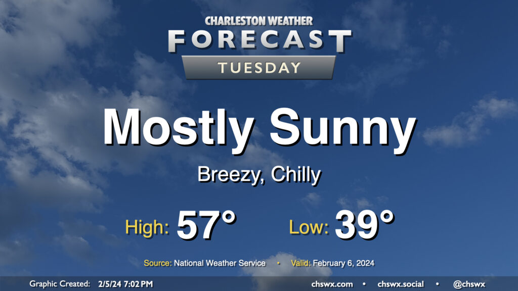
Showers have ended and cloud cover will diminish overnight, yielding a sunny Tuesday — in stark contrast to the dreariness that was Monday. However, high pressure trying to build in from the west will help to keep the gradient pinched as low pressure remains offshore, keeping north to northeast winds elevated throughout the day. Temperatures will start in the upper 30s, but the wind chill will make it feel more like 30°, so dress appropriately in the morning. We’ll warm only to the mid-to-upper 50s despite the sunshine, too.
The other issue for Tuesday will be the risk for some minor to moderate coastal flooding very early Tuesday morning. High tide around 4:32am is forecast to reach between 7.5-7.7′. While we fell just short of coastal flood criteria Monday morning, it certainly seems more likely that we’ll achieve flood stage on Tuesday. So, if you have early travels that take you downtown, be ready to reroute around flooded roads.
Rest of the work week: Warming up
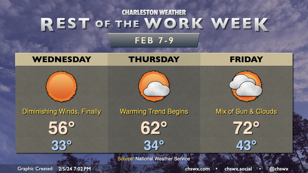
The temperature roller coaster pitches back up as we head into the second half of the work week. High pressure will move overhead Wednesday, which will allow winds to diminish throughout the day. Still, it’ll be a rather chilly start — expect lows very near freezing in the metro, with wind chills well into the 20s. High temperatures will again run a few degrees below normal — generally in the mid-50s — despite the diminishing winds and continued sunshine. We may have another round of minor coastal flooding Wednesday morning, too; we’ll need to keep an eye on tidal trends.
A warming trend begins Thursday, though, as high pressure slips offshore. It’ll be another chilly mid-30s start, but temperatures will head to the low 60s in the afternoon, right where we should be at this point in February. Cloud cover will be increasing as flow aloft goes southwesterly and moisture return begins to improve. The aforementioned cloud cover will help Friday start almost 10° warmer than Thursday did with lows generally in the low to mid-40s, and temperatures will head to the low 70s as warmer air pumps into the area from the south. Cloud cover will continue to increase, but any rain should hold off until at least Saturday ahead of a cold front.
Follow my Charleston Weather updates on Mastodon, Bluesky, Instagram, Facebook, or directly in a feed reader. Do you like what you see here? Please consider supporting my independent, hype-averse weather journalism and become a supporter on Patreon for a broader look at all things #chswx!