Labor Day weekend: Sending off summer with warm temperatures, then storms
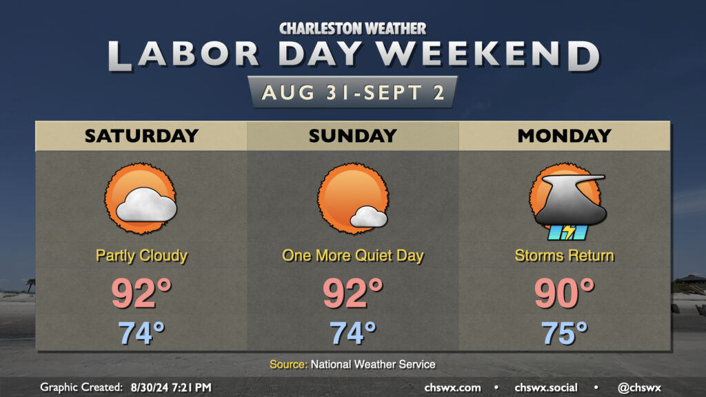
It’s a Meat Loaf-like Labor Day weekend this year: Two out of three ain’t bad. We’ll continue this stretch of warm but mostly quiet weather (aside from a stray shower on the seabreeze) for Saturday and Sunday. Expect to start each day in the mid-70s, warming to the low 90s in the afternoon. Heat indices will generally run in the upper 90s — certainly still hot, but it could (and has!) been much worse.
Attention then turns to a front that will move into the area on Monday. We’ll see the risk for showers and thunderstorms increase throughout the day as the front sags south into the region. Temperatures will peak around 90° one more time before the front ushers in cooler air and continued unsettled weather as we get into the working portion of next week. Severe weather doesn’t look to be a major concern, but we could see brief periods of heavy rain and lightning from any thunderstorm that fires. Remember: when thunder roars, go indoors!
Tropics: Now up to three areas to watch
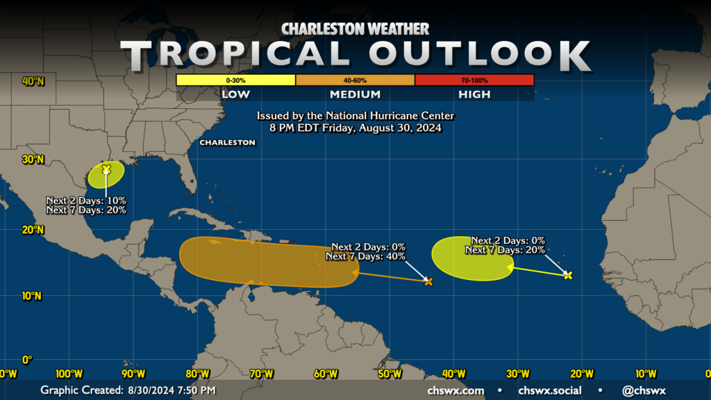
Well, the Tropical Outlook map certainly looks like the end of August, that’s for sure. The National Hurricane Center is monitoring three areas in the Atlantic basin for possible tropical development over the next week. The best chance of development in the next week is found with a disturbance around 44°W and 12°N, which is the spot we’ve been talking about for a few days now. NHC gives this area a 40% chance to develop over the next week as it crosses over the Lesser Antilles and ends up in the Caribbean. The second area is found just off the coast of Africa south of the Cabo Verde Islands. This area has a 20% chance to develop within the next week as it moves past 30°W. There’s a ton of time to watch these two areas of interest, so no worries for now.
The third area is in the Gulf of Mexico associated with an upper low that has spawned a surface low. It has a 10% chance to develop over the weekend, with a 20% chance over the next seven days as it brings some rain to Louisiana and Texas. It’s not likely to pose any concern for our weather here in the Lowcountry especially given how far to the west it is. We’ll continue to keep an eye on things with all three of these areas of interest in case they become more interesting.
Follow my Charleston Weather updates on Mastodon, Bluesky, Instagram, Facebook, or directly in a feed reader. Do you like what you see here? Please consider supporting my independent, hype-averse weather journalism and become a supporter on Patreon for a broader look at all things #chswx!