Tuesday: Mostly cloudy but still warm
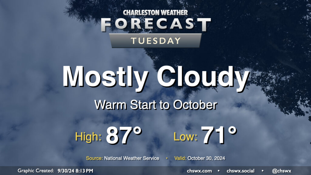
We’ll get October off to a warm but somewhat cloudy start before a cold front starts to regulate temperatures a bit more beginning Wednesday. We start the day rather mild for this time of year once again, with low 70s generally across the metro (and warmer toward the coast). Cloud cover does persist, but despite that, we’ll still warm into the upper 80s. Rain is not expected.
Rest of the work week: Generally pleasant
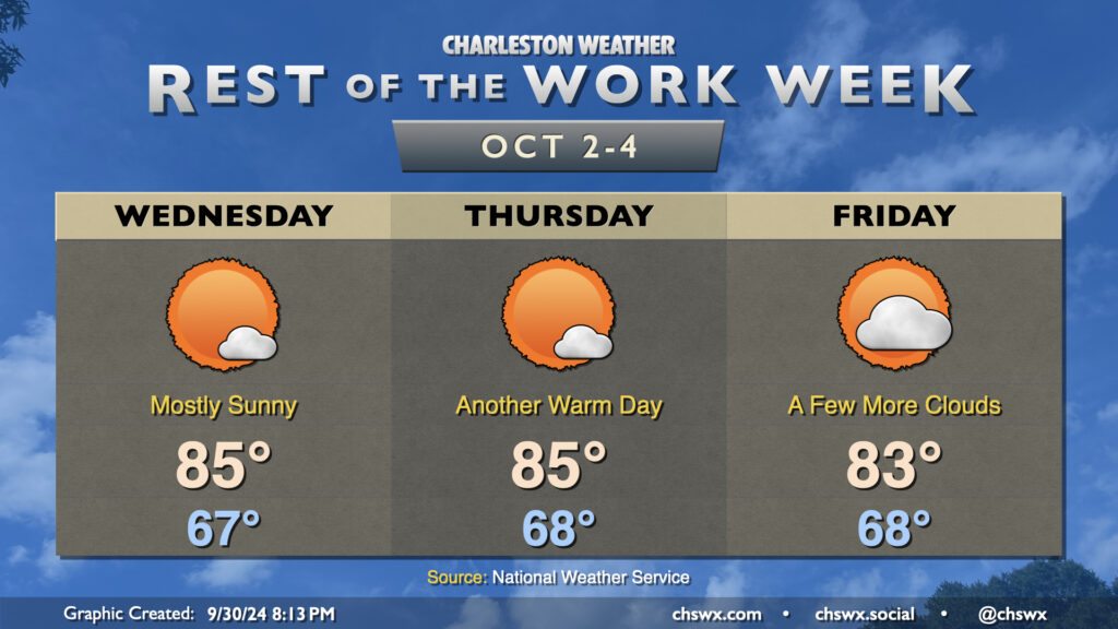
A front gets through Wednesday with some slightly cooler and drier air, making things still seasonably warm but not quite as summer-ish. We start Wednesday in the upper 60s, warming to the mid-80s in the afternoon with much more in the way of sunshine. Thursday is essentially a copy and paste day forecast-wise with more sun and mid-80s. High pressure sliding across the Northeast starts to wedge into the area for Friday, ticking up the cloud cover a bit and helping to keep temperatures down a couple degrees from Thursday. Rain remains highly unlikely through the period.
Post-Helene river flooding forecast
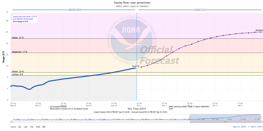
Runoff from Helene’s incredible deluge across the Upstate and western North Carolina will be making its way to the coast over the next week or so. While much of the Charleston metro area resides in watersheds that aren’t going to be terribly affected by this runoff, the Santee River is an exception. Santee Cooper is lowering lake levels on Lake Marion and Moultrie to handle the extra runoff, and there will be major river flooding down the Santee as we head through this week. The Santee River at Jamestown forecast point is already in minor flood and is expected to reach 24.3′ on Saturday, which should be close to its crest. This is well into its major flood stage, which could affect properties on Crow Hill Drive and Lawton Farm Lane according to NOAA.
Helene final totals: Six tornadoes, 1-3″ of rain, gusts 55+ MPH
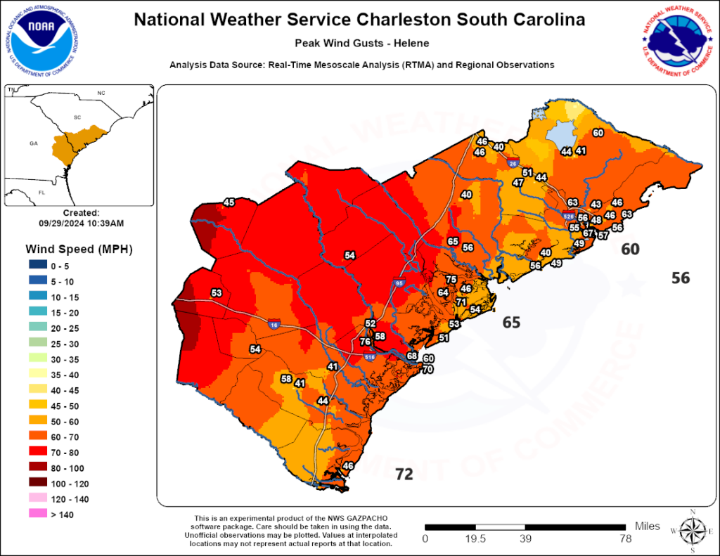
The National Weather Service in Charleston has posted its summary of Hurricane Helene. Out of the deluge of tornado warnings, six have been confirmed from Helene, two of which touched down in the Red Top area on the far reaches of West Ashley. It remains to be seen if any additional tornadoes will be confirmed, but honestly, it’s incredible (and fortunate!) that there haven’t been more found because of just how much rotation there was on the radar Thursday night and Friday morning.
Winds were definitely quite an issue here in the metro, too, with several stations reporting maximum gusts over 60 MPH, including a 67 MPH gust in downtown Charleston.
Tropics: Still busy; Gulf probabilities decreasing
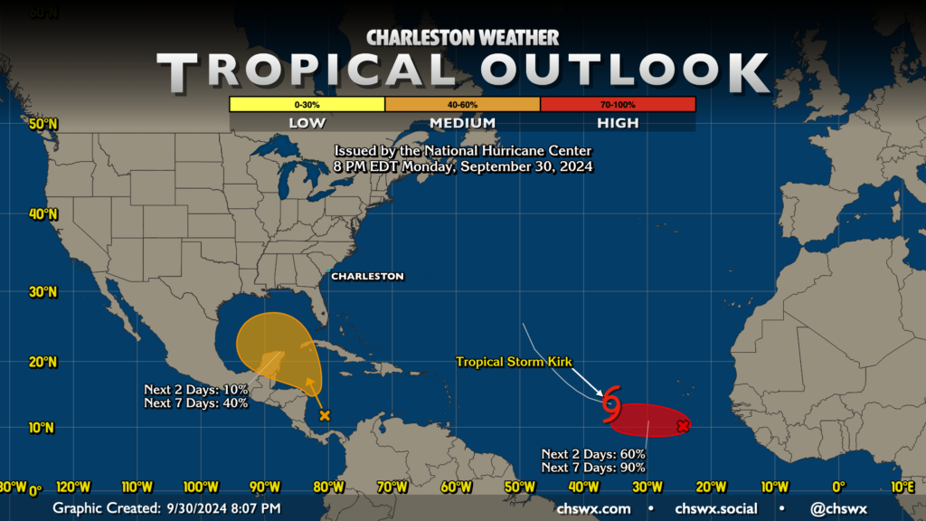
Looking into the tropics, things continue to be somewhat busy, but there are also no immediate concerns for our neck of the woods. Tropical Storm Kirk, christened today, is expected to reach major hurricane strength later this week while laying in a course for recurvature into the open Atlantic, boldly going where Joyce had gone before and, most importantly, staying away from land.
A second area of disturbed weather just to the south-southeast of Kirk should develop into a tropical cyclone this week, but it’s very far out and ensemble guidance generally shows it not posing a risk to land either. The area in the Caribbean and Gulf which has had some of us on edge lately is actually showing a lower probability of generating a tropical cyclone in the next week, with chances down to 40%. Guidance continues to generally paint a picture of perhaps a weak low, but that’s it. We’ll keep an eye on this in case things change, but for now, nothing scary is expected.
Follow my Charleston Weather updates on Mastodon, Bluesky, Instagram, Facebook, or directly in a feed reader. Do you like what you see here? Please consider supporting my independent, hype-averse weather journalism and become a supporter on Patreon for a broader look at all things #chswx!