Weekend forecast: Seasonable warmth continues with a mix of clouds and sun
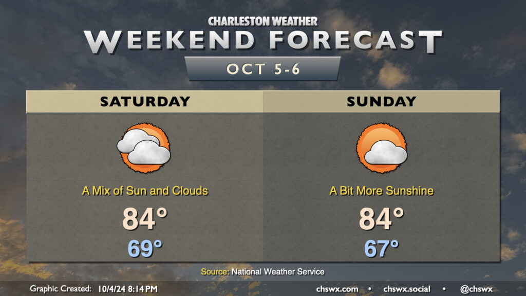
Quiet weather is expected this weekend as high pressure remains in control. Friday’s occasional showers will be a thing of the past on Saturday as cloud cover gradually thins throughout the day. We start Saturday in the upper 60s, warming to the mid-80s in the afternoon.
More sunshine is in the offing for Sunday as a trough of low pressure aloft moves out and a little bit of ridging moves in. We start the day a touch cooler, generally in the mid-to-upper 60s, warming once again to the mid-80s in the afternoon under partly cloudy skies.
The next front, which arrives with little fanfare on Monday, should finally bring a shot of more fall-like air into the area for next week, with lows possibly dipping into the 50s by next Thursday. Overall, the outlook is for generally quiet and dry weather for at least the next several days.
Tropics: Still active, but no major Lowcountry concerns
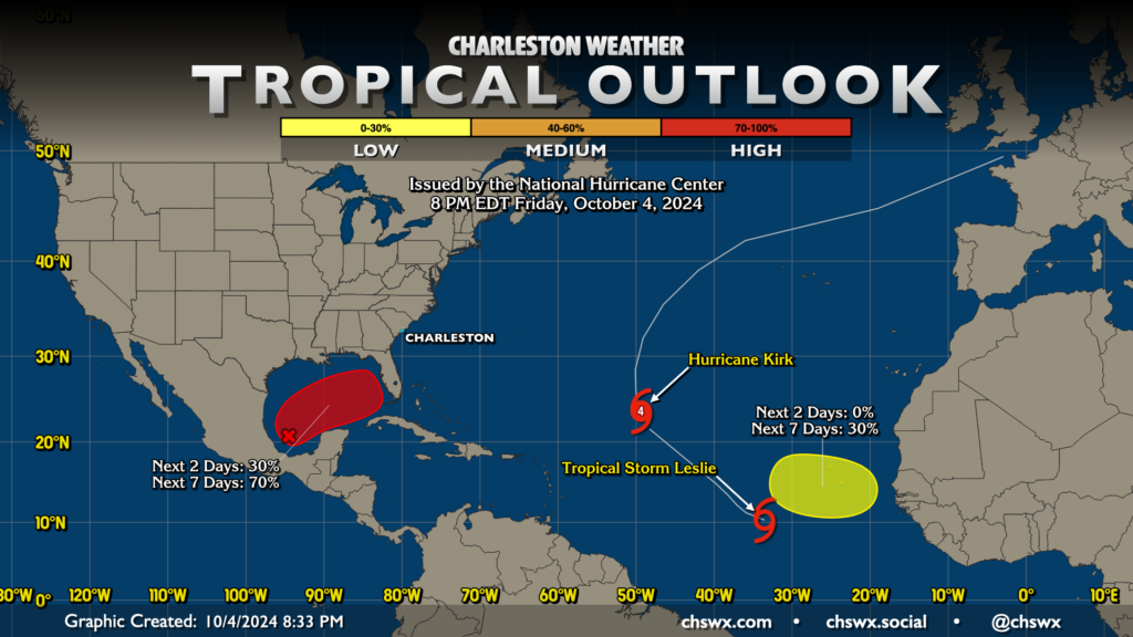
The tropics remain active as we head into the first weekend in October, with the Cabo Verde season getting a bit into overtime with two active cyclones, Category 4 Hurricane Kirk and Tropical Storm Leslie, along with a third area of interest that could develop over the next couple weeks. These look to stay way out in the Atlantic at this point, and are not a concern for much, if any, land until later next week as Kirk’s remnants approach Europe.
Closer to home, the area in the Gulf of Mexico that has attracted intrigue pretty much ever since Helene plowed ashore last week has been trending more favorably toward tropical development once again. The National Hurricane Center has classified this area of disturbed weather as Invest 92L, giving it a 70% (or high) chance to develop over the next week. Regardless of development, this could potentially be a big rainmaker for parts of the Florida peninsula, and will need to be watched there closely. It is less clear how much of an impact, if at all, would be felt this far north, though a period of enhanced onshore winds may not be out of the question at some point next week. Guidance is very inconsistent on the timing and strength of this prospective storm, so all we can do right now is monitor. For now, though, there’s no expectation for any direct impacts here in the Lowcountry, and the pattern so far suggests we’ll remain just fine.
Follow my Charleston Weather updates on Mastodon, Bluesky, Instagram, Facebook, or directly in a feed reader. Do you like what you see here? Please consider supporting my independent, hype-averse weather journalism and become a supporter on Patreon for a broader look at all things #chswx!