Tuesday: Last 80s for a few days as we watch Milton
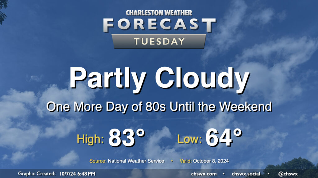
Quiet and warm weather continues Tuesday as we continue to monitor Hurricane Milton in the Gulf of Mexico for possible peripheral impacts on the Lowcountry as we get into Wednesday night and Thursday. Expect a comfortable start in the mid-60s on Tuesday, with temperatures warming to the low-to-mid-80s in the afternoon under partly cloudy skies (though clouds will be increasing as the day goes on). Northeast winds will generally run 10-15 MPH across the metro.
All eyes on Milton as it becomes one of the strongest Atlantic basin storms on record
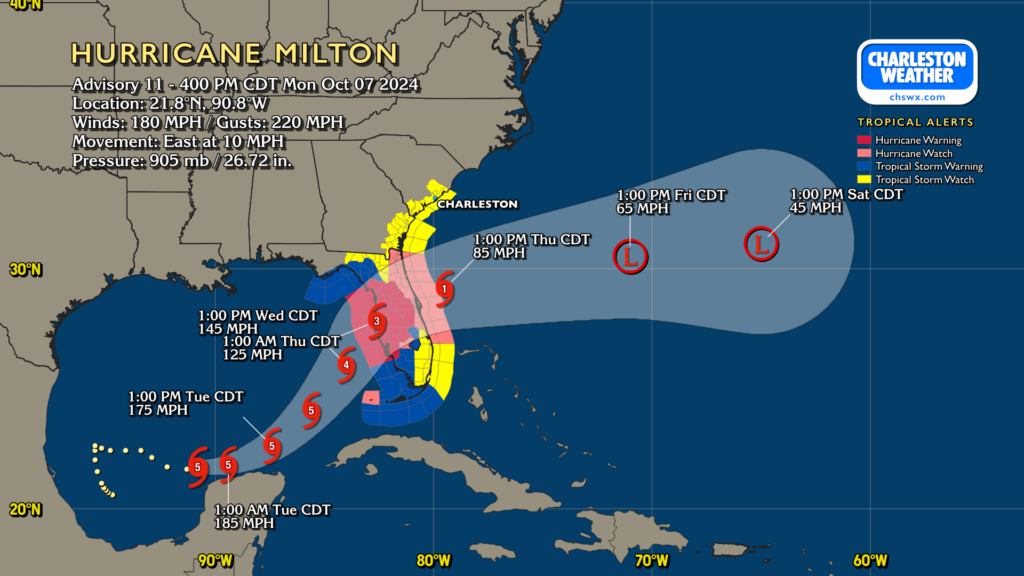
Hurricane Milton underwent an unbelievable period of rapid intensification on Monday, reaching Category 5 strength by midday and seeing the central pressure drop almost 70 millibars over 12 hours. Pressure in Milton as of the 5PM advisory is now down to 905mb, which ties Dean for ninth strongest hurricane on record in the Atlantic based on pressure. Hurricane hunter data at the time of this writing suggests that Milton’s pressure may actually be lower, with a reading of 898mb noted in a recent pass, indicating strengthening continues.
Milton’s strength should peak overnight with maximum sustained winds of 185 MPH before starting a steady weakening trend due to eyewall replacement cycles. These cycles will broaden Milton’s wind field as it approaches Florida, and this broadening will continue through landfall as it encounters shear and a frontal system at the surface. NHC continues to show Milton as a strong Category 3 hurricane at landfall in western Florida, which is a nightmare scenario for the Tampa metro. Evacuation orders are in effect there, and it’s critical that folks heed those as storm surge will easily range between 10-15′ near and south of the center.
Locally, a Tropical Storm Watch is in effect for Berkeley and Charleston counties and should become a warning sometime on Tuesday. The best chance for tropical storm conditions will be found at the coast, but gusts to tropical storm force will be possible elsewhere as well.
Lowcountry impacts from Milton: What to expect
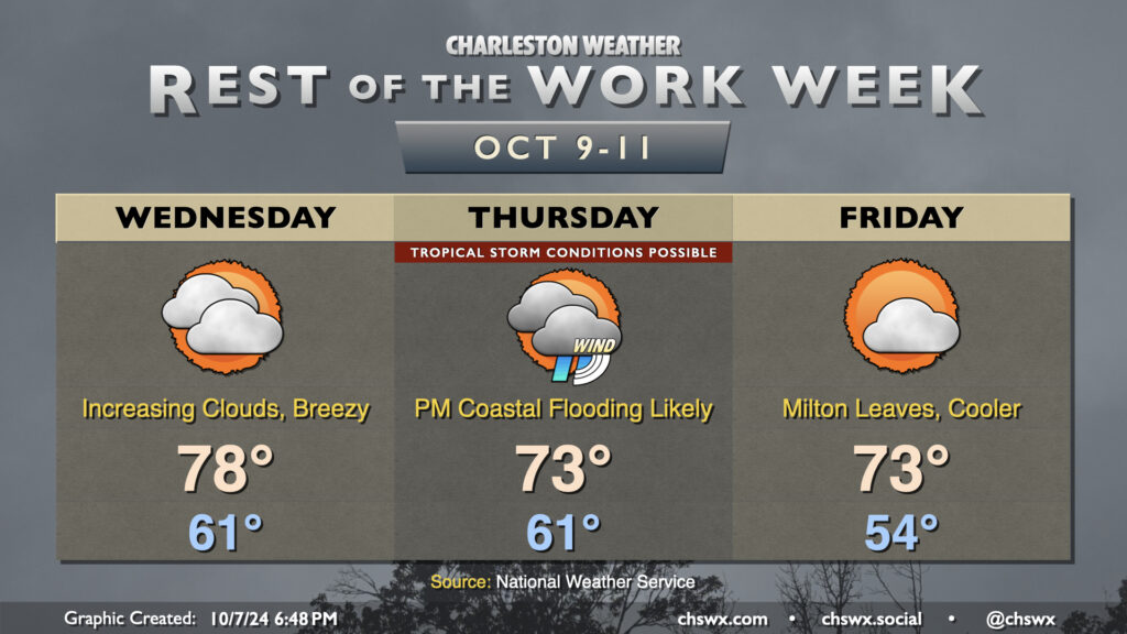
Based on the current forecast track from the National Hurricane Center, Milton’s impacts look generally confined to Wednesday night through Thursday, with coastal flooding emerging as the greatest concern for the Charleston metro on Thursday. There is still a fair bit of uncertainty with how far north Milton’s track will go, and deviations could change the magnitude of our impacts.
Wednesday will run a bit cooler as the northeast breeze starts to pick up. We start the day in the low 60s, warming to the upper 70s in the afternoon with increasing cloud cover ahead of Milton. Gusts should begin to pick up in earnest over the metro overnight Wednesday and into Thursday. As mentioned, the best risk for tropical storm-force winds (39 MPH+) will be found near the coast. Some stronger gusts will be possible, and we can’t rule out the risk for some power outages due to the wind in portions of Charleston and Berkeley counties.
On the present track, rain will not be a terribly huge factor with Milton — many spots may not see any rain at all, especially the further north and west you are. A few spots could see an inch or two of rain, but most will see generally below that. The risk for rain generally runs through the day Thursday, tapering Thursday evening as Milton departs.
One bit of good news: There is no risk for tornadoes from Milton here in the Lowcountry. We’ll be on the far fringes of the north side of the circulation, and with a stalled front to the south, the air will be cool and relatively stable, and the more favorable shear for tornadoes will be found well to our south.
Minor coastal flooding possible Tuesday and Wednesday, with major coastal flooding possible Thursday
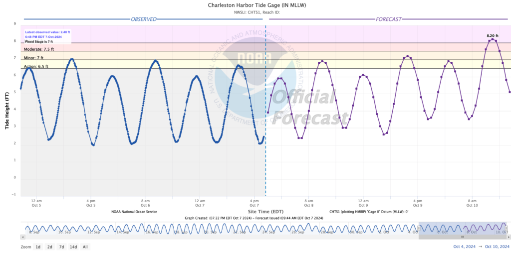
Coastal flooding is emerging as our main concern from Milton thanks to a very persistent and stiff northeasterly breeze through the bulk of the event. As Milton approaches the area, the gradient between the low pressure to the south and high pressure to the north will tighten, which will help drive water loading along the coast. This, in turn, could lead to minor coastal flooding with the midday Tuesday high tide, but will more likely cause minor flooding early Wednesday afternoon.
Thursday is the day to watch, though, as Milton’s surge is expected to peak. This should drive water levels in Charleston Harbor into flood stage by midday, peaking around major flood stage in the 2-3PM timeframe before gradually receding into the evening. Numerous road closures due to salt water flooding will be possible, and any rain on top could complicate matters further. Salt water flooding at these heights also begins to become a significant impediment on the Sea Islands and in Mt. Pleasant, so we’ll need to watch for the potential for traffic disruption carefully. There’s an outside risk that major flooding could occur again overnight Thursday into early Friday, too, so we’ll keep watch on that.
Stay tuned for forecast updates
The impacts forecast above is contingent on Milton doing what we think it’s going to do. While track guidance is generally locked in pretty well on the idea of a Florida peninsula crossing, a bit of a wobble north could increase our impacts, and vice versa. Check back into forecast updates regularly for possible changes.
Improving weather Friday and into the weekend
Milton will be departing Thursday evening, and by Friday we should be in pretty good shape (if not still a little breezy). It’ll be a very fall-like day, with lows in the mid-50s yielding to highs in the low 70s in the afternoon under increasingly sunny skies. Temperatures moderate for the weekend as sunshine continues with high pressure in control.
Follow my Charleston Weather updates on Mastodon, Bluesky, Instagram, Facebook, or directly in a feed reader. Do you like what you see here? Please consider supporting my independent, hype-averse weather journalism and become a supporter on Patreon for a broader look at all things #chswx!