Tuesday: Cooling trend begins
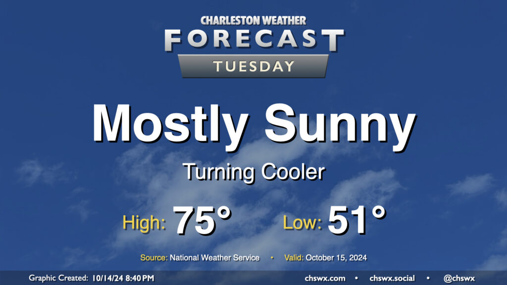
After a day of record temperatures, in which a new record high was set downtown and another record high was tied at the airport, we will begin to turn sharply cooler as a series of fronts, one of which came through this afternoon, starts to bring in some of the coolest air so far this season.
Tuesday’s temperatures, despite plenty of sunshine, will run a little below normal for this point in October. We start the day in the low 50s, warming to the mid-70s in the afternoon. Clouds will be hard to come by, though they should begin to increase after midnight. That being said, it should be another solid evening of stargazing in the western sky as Comet Tsuchinshan–ATLAS continues to appear in the night sky after sunset.
Rest of the work week: Break out the sweaters
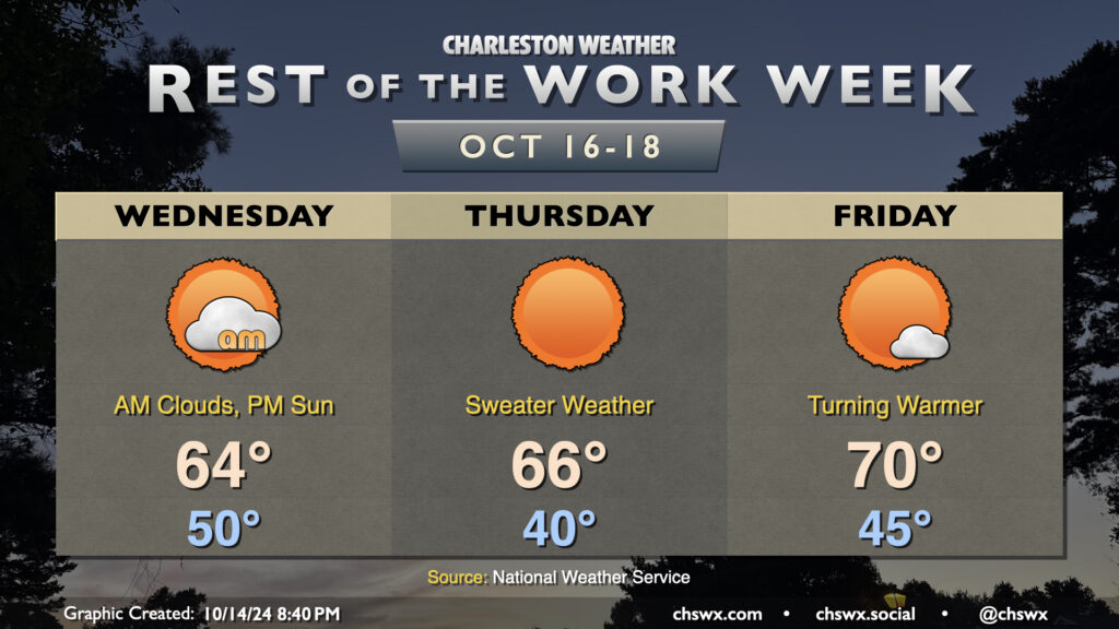
A secondary front will move through overnight Tuesday into early Wednesday. It’ll be a dry front with just an uptick in cloud cover accompanying it, but don’t let the lack of rain fool you: this is a strong front. We’ll see winds swing around to the north and turn somewhat gusty during the day Wednesday as the coolest air of the season so far works into the area. We start Wednesday around 50°, but despite the decreasing cloud cover, highs should only peak in the mid-60s in the afternoon.
The breeze stays up through Thursday, so while radiational cooling won’t be as effective, it’s still going to be as cold as it’s been since mid-March as lows dip to around 40° (and perhaps even into the 30s well inland). The northerly breeze will drive the wind chill down into the low to mid-30s, so you’ll definitely want a sweater (if not a full-blown jacket) at least in the morning. There’s plenty of sun, but temperatures only warm back to the mid-60s once again on Thursday afternoon.
A warming trend commences Friday as high pressure aloft starts to move into the area. We start Friday in the mid-40s, though a northeasterly breeze may continue to make it feel closer to the upper 30s in the morning. Temperatures will warm back to around 70° in the afternoon with just a few passing clouds from time to time. This will signal the beginning of a warming trend that will carry through the weekend into next week — yes, we have another pretty stellar weekend of weather coming up, it looks like!
Coastal flooding issues return
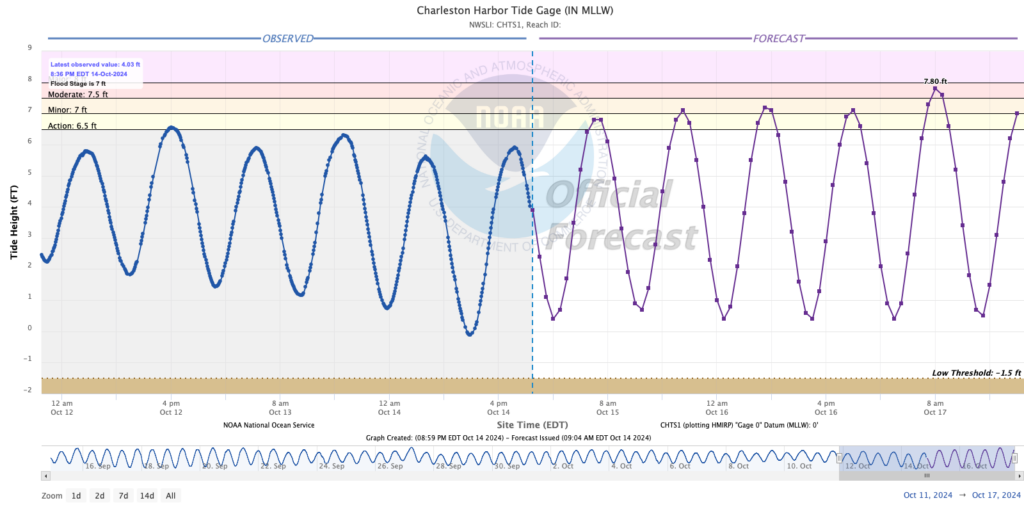
Unfortunately, it can’t all be perfect, as the upcoming full moon will increase the risk of coastal flooding with each high tide beginning Tuesday evening. At least minor flooding is expected with each high tide for the rest of the work week, with more disruptive moderate flooding possible Thursday morning around commute time as winds go more around to the more favorable northeasterly direction. Keep an ear out for Coastal Flood Advisories from the National Weather Service as your signal for periods of possible road closures.
Tropics: A couple spots, but no worries at this point
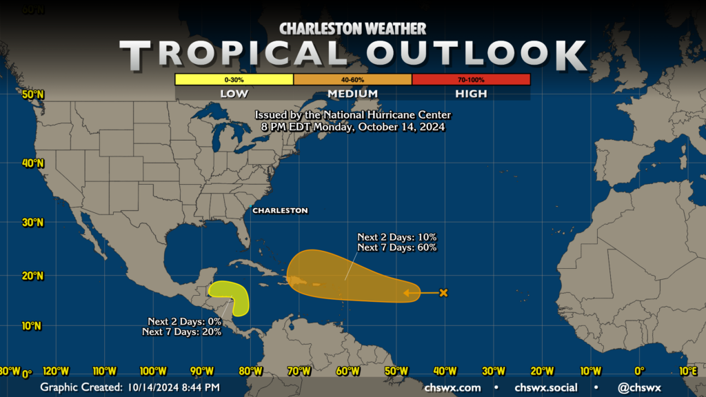
Our respite from named storms should continue for a few more days, though there are two areas of concern in the Atlantic basin. The first area, classified as Invest 94L, is located around 40°W and 27°N. It’s expected to move into a more favorable area for development as we get later into the week, and has a 60% chance of developing into a tropical cyclone over the next seven days. The pattern that’s taken shape over the continental US is certainly favorable for keeping this away from the States, but we’ll keep an eye on it regardless.
A second area of interest has been identified by NHC around Central America. There’s a 20% chance something could spin up here over the next few days, though with high pressure set up solidly to the north, it would just plow westward into land before it could really get going. So, nothing for us to worry about with this one right now (and perhaps never), too.
Follow my Charleston Weather updates on Mastodon, Bluesky, Instagram, Facebook, or directly in a feed reader. Do you like what you see here? Please consider supporting my independent, hype-averse weather journalism and become a supporter on Patreon for a broader look at all things #chswx!