Thursday: Front takes the edge off the heat
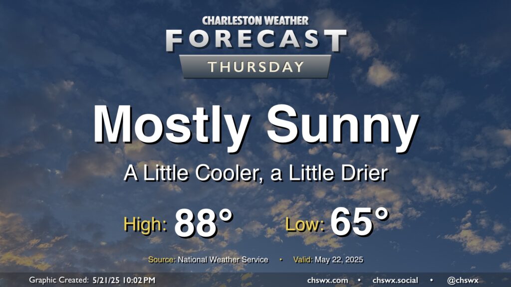
A reprieve from the early-season stretch of 90° temperatures commences Thursday in the wake of a cold front. We’ll start the day noticeably cooler and drier than previous days, with lows bottoming out in the mid-60s as opposed to the low 70s. Highs will still run a little warmer than normal, but upper 80s will still represent cooler highs, especially on the heels of highs in the low 90s the past few days. Despite the warmer-than-normal temperatures, the lower dewpoints in the mid-50s will send relative humidity values down to around 30% or so during the day, so at least any sweat will have a chance to do its thing to cool you off.
Friday & Memorial Day Weekend: More seasonable start, but warming back up to the 90s
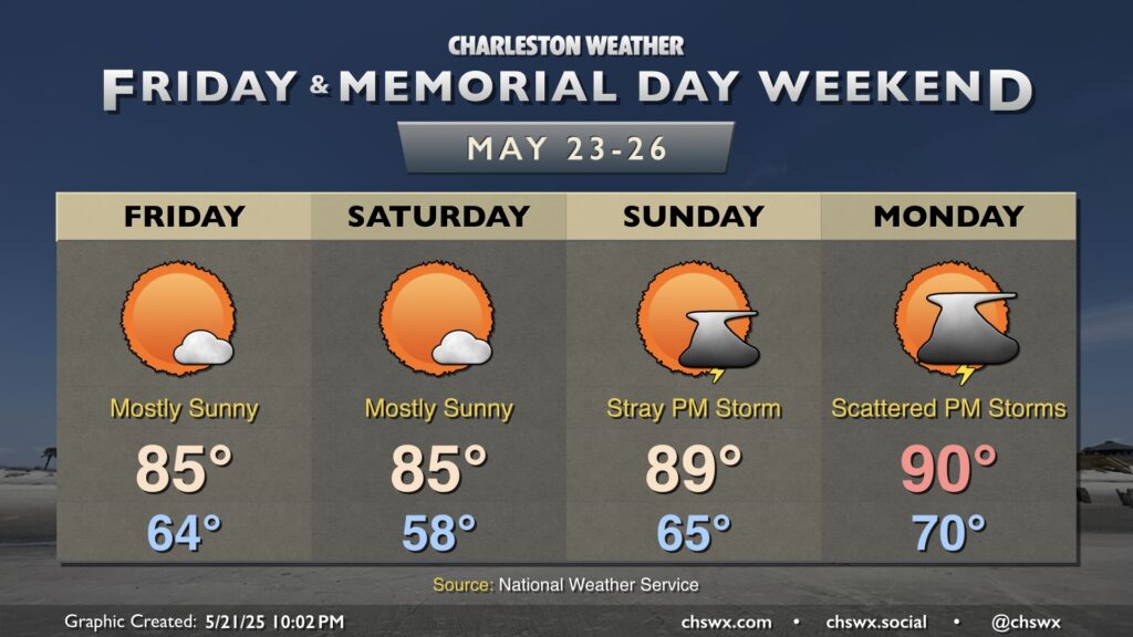
Temperatures will continue to run right around normal and the weather will be quiet as we head into Memorial Day Weekend, courtesy of high pressure building across the area. Temperatures Friday start in the mid-60s and warm to the mid-80s, while Saturday should start with some increasingly-refreshing upper 50s before warming back to the mid-80s in the afternoon.
Warmer and more humid air begin to return Sunday as a warm front starts to lift north. Lows on Sunday will be noticeably warmer than they were on Saturday (mid-60s vs. upper 50s), though still within spitting distance of normal. We’ll warm to the upper 80s to near 90° in the afternoon. This will come along with some slight shower and thunderstorm chances as we get later in the day Sunday, though widespread plan-ruining rain is not expected.
Memorial Day will be a fitting unofficial start to summer with lows around 70° warming to around 90° in the afternoon — a very late June-type temperature profile but in late May. A few thunderstorms will be possible in the afternoon, but coverage should not be enough to cause widespread issues with outdoor activities. Still, have a backup plan just in case. Remember: When thunder roars, go indoors.
Follow my Charleston Weather updates on Mastodon, Bluesky, Instagram, Facebook, or directly in a feed reader. Do you like what you see here? Please consider supporting my independent, hype-averse weather journalism and become a supporter on Patreon for a broader look at all things #chswx!