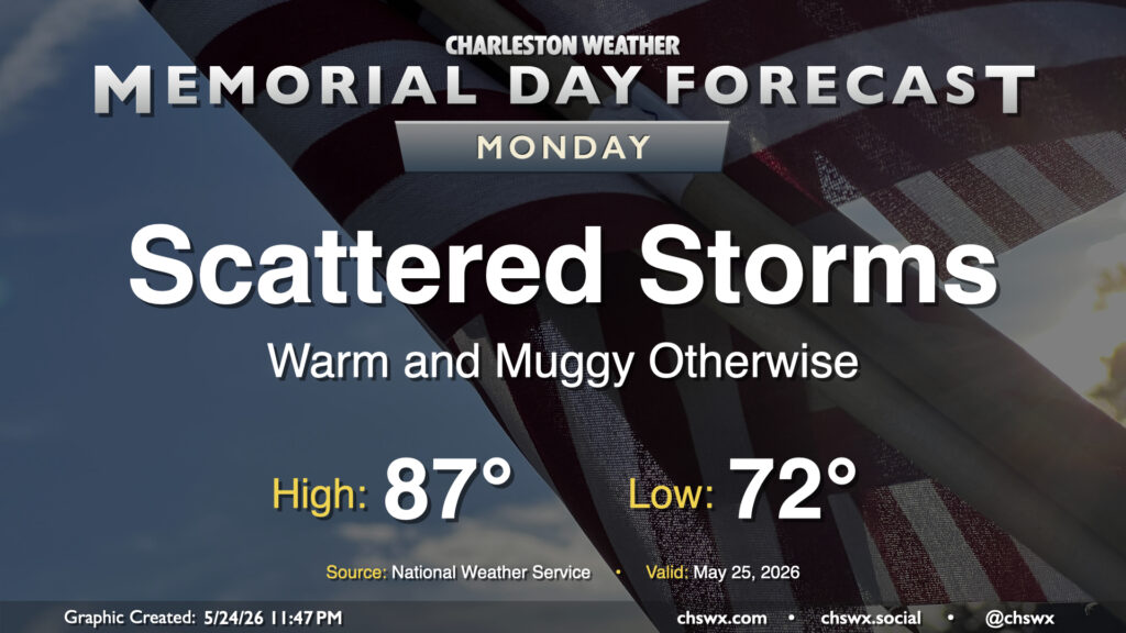
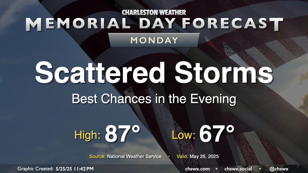
A few more showers and thunderstorms will be possible on Memorial Day, but overall it will be a fairly decent representation of summertime. We’ll start the day in the low 70s, warming to the mid-to-upper 80s in the afternoon. Showers and thunderstorms will be most likely in the morning, propagating inland during the day. Coverage will be less than Sunday, but you’ll still want to keep an ear out for thunder, which will be your signal to head indoors as at that point, you are at risk of getting struck by lightning. However, this is no reason to cancel any outdoor plans — just make sure you’ve got a good secondary, indoor plan.
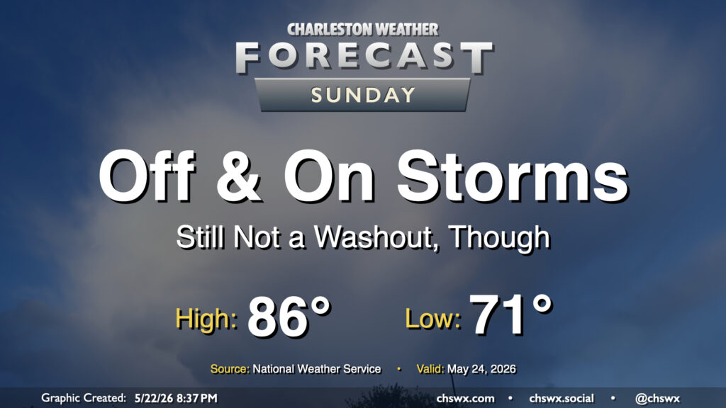
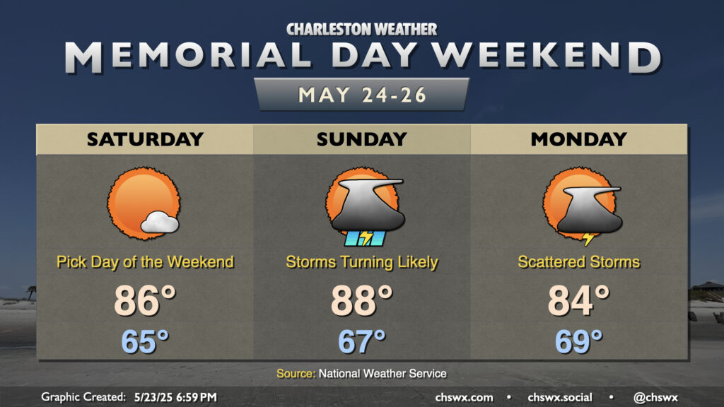
Showers and maybe a few thunderstorms will continue to be in play for the forecast as we get into the midpoint of the long Memorial Day weekend, though the greater activity will continue to be found along and west of the I-95 corridor. For Sunday, we can expect the bulk of our activity likely during the morning and early afternoon hours before the seabreeze pushes inland and takes most of the activity with it. However, showers will be possible throughout the day, so be ready to move outdoor plans inside just in case a shower or thunderstorm approaches.
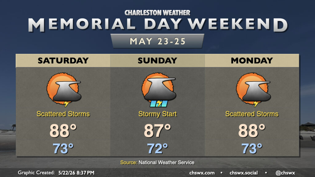
Shower and thunderstorm chances will accompany a warm and muggy Memorial Day weekend, but don’t expect a rainout, either. Temperatures will generally run in the upper 80s each day, but dewpoints around 70° will make it feel closer to 90-91° pretty much every afternoon.
It’s a very summer-like look to the forecast this Memorial Day Weekend as the Lowcountry sits on the fringes of Atlantic high pressure. The pattern is largely stagnant as evidenced by the copy & paste temperatures for the next few days: lows in the low to mid-70s, highs in the upper 80s to near 90°.
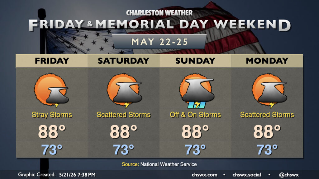
While we probably won’t get off to as stormy of a start as we did on Sunday, expect another round of showers and storms to kick off by afternoon on Memorial Day. We’ll start the day in the mid-to-upper 60s, warming to the mid-to-upper 80s in the afternoon before thunderstorms once again kick off with a stalled front in the vicinity. The risk for severe weather remains on the low side, but heavy rain and lightning will still be enough to disrupt outdoor plans at times. Storm motions will be toward the coast as well, so be especially alert for thunderstorms at the beaches. Remember, all thunderstorms are dangerous due to the lightning they produce. If you see lightning or hear thunder, you’re close enough to be struck, and should move inside.
We’ll also want to pay close attention to the flooding threat not only from training thunderstorms but also the evening high tide, which should peak between 7.1-7.3’ MLLW around 8:16 PM. If thunderstorms are in the area around that time (as some models seem to suggest), this could indicate a greater flooding threat for vulnerable locations in downtown Charleston. This will certainly be something to watch as the day progresses. Stay alert for possible flood advisories from the National Weather Service.
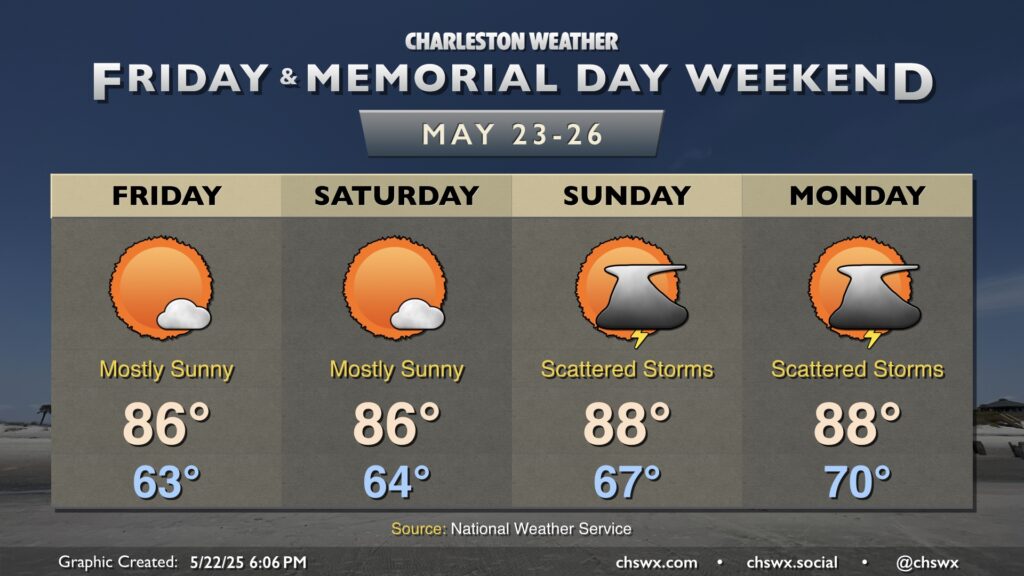
Generally quiet weather featuring plenty of sunshine and seasonable temperatures will bring us into Memorial Day Weekend as high pressure builds in at the surface for a couple days. Friday will start in the low-to-mid-60s and warm to the mid-80s in the afternoon with low humidity. It’ll still be a bit breezy, but not to the extent as we saw on Thursday.
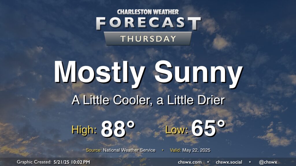
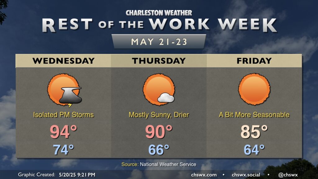
A reprieve from the early-season stretch of 90° temperatures commences Thursday in the wake of a cold front. We’ll start the day noticeably cooler and drier than previous days, with lows bottoming out in the mid-60s as opposed to the low 70s. Highs will still run a little warmer than normal, but upper 80s will still represent cooler highs, especially on the heels of highs in the low 90s the past few days. Despite the warmer-than-normal temperatures, the lower dewpoints in the mid-50s will send relative humidity values down to around 30% or so during the day, so at least any sweat will have a chance to do its thing to cool you off.
The unseasonable warmth of the past week and change will draw to a close on Wednesday as a cold front approaches the area. We’ll start Wednesday in the mid-70s, warming to the mid-90s in the afternoon. There’s a chance for a storm or two ahead of the front, but it’s conceivable that many of us may not see any rain at all with this frontal passage. If a storm or two can get going, it could turn strong to severe, but the chances are very low.
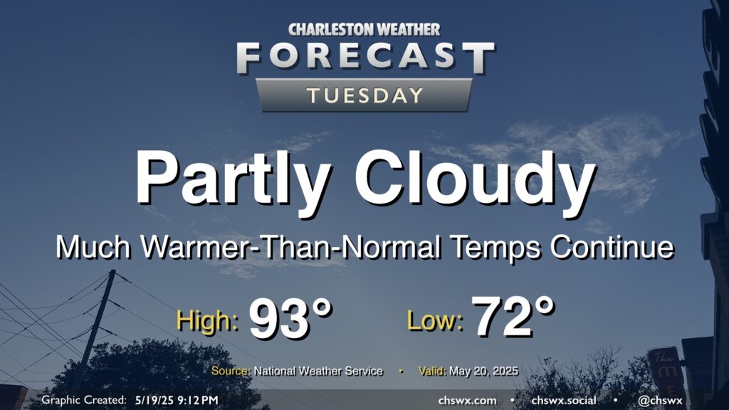
Expect less in the way of cloud cover on Tuesday as the front that helped focus some shower and thunderstorm activity across the area on Monday meanders north and high pressure builds in aloft with plenty of dry, sinking air to be found. We’ll stay on the toasty side of normal for mid-May, with lows in the low 70s warming to the low-to-mid-90s in the afternoon. Dewpoints aren’t terribly out of control, thankfully, so heat indices won’t be too much of a factor, only running about 2-3° or so above the air temperature. That said, it’s still quite warm for this point in the year — the normal high for May 20 is 84°.