Tuesday: A few storms possible as coastal hazards from Erin ramp up
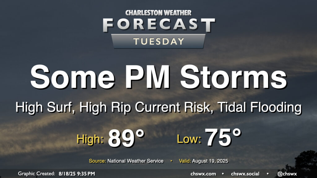
After an uncharacteristically quiet Monday (weather-wise, anyway), Tuesday should feature a few more storms as a little energy aloft moves through and interacts with the afternoon seabreeze. Temperatures start in the mid-70s, warming to the upper 80s to around 90° before thunderstorms disrupt the temperature curve for some of us. Models do indicate some isolated heavy downpours, though with less in the way of deep moisture, the flooding threat shouldn’t be terribly high.
Erin’s coastal impacts to be felt this week
The main concern heading into the meat of the week is the risk for significant coastal impacts from Hurricane Erin’s pass to our east. The NWS office in Charleston received 12 rip current reports from the coastal areas in Georgia and SC that they serve, and this should tick up even more over the next few days. A High Surf Advisory and a high risk of rip currents begins Tuesday and lasts through at least Thursday as Erin makes its closest approach. The ocean will be angry and a dangerous place to be, especially for inexperienced swimmers.
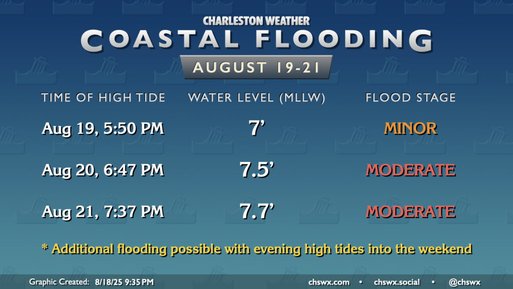
Coastal flooding is also expected to become an issue with the evening high tides beginning Tuesday. Minor flooding will be possible around Tuesday evening’s high tide, peaking near 7′ around 5:50 PM. Moderate flooding becomes more likely as we get into Wednesday and Thursday, with tides peaking around or above 7.5′ expected. Flooding should continue with the evening high tide cycles heading into Friday and the weekend, too, though with gradually diminishing impacts as Erin departs to the northeast.
Rest of the work week: A few quieter days as storms go
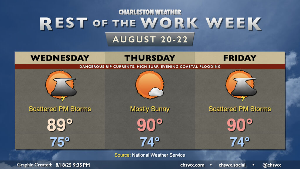
The flip side of Erin’s impacts will be somewhat drier air moving into the area from the north on the periphery of Erin’s circulation, helping to tamp down storm chances for at least a couple days and take a little edge off the humidity. We can still expect a few afternoon storms on Wednesday, but drier air pushes into the area for Thursday as winds go more northerly and even a little northwesterly, keeping skies mostly sunny during the day. As Erin departs, though, moisture will kick back up, and the risk for afternoon thunderstorms returns for Friday as a result. We’ll keep elevated afternoon storm chances through the weekend as another trough of low pressure nearby along with the seabreeze help to act as focal points for thunderstorm formation.
Tropics: Two areas behind Erin to watch
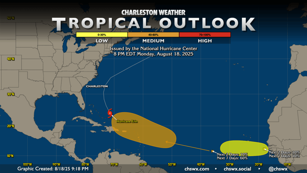
As Erin splits the uprights between the southeastern US and Bermuda, two other areas of interest will follow. The first, a wave approaching 40°W, has a 60% chance to develop over the next week as it approaches the Leeward Islands and Puerto Rico. Models have been consistent about the idea that something develops here, but there’s still a fair bit of disagreement as far as timing and strength go. Plenty of time to watch, though.
The second area is a wave that just came off Africa, which has a relatively low chance of development in the near term as it moves south of the Cabo Verde Islands. It’ll move into a bit more hostile development conditions as we get into later this week, keeping those development chances rather low (10%). We’ll keep an eye on this as well, but it’s not much to write home about at this point.
Follow my Charleston Weather updates on Mastodon, Bluesky, Instagram, Facebook, or directly in a feed reader. Do you like what you see here? Please consider supporting my independent, hype-averse weather journalism and become a supporter on Patreon for a broader look at all things #chswx!