Thursday: Another warm day, but changes are afoot
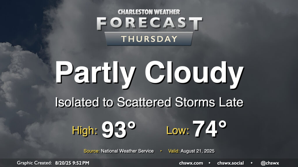
Thursday will be another warm day across the Lowcountry, with lows in the mid-70s warming to the low-to-mid-90s in the afternoon. Heat indices will run in the upper 90s to perhaps 100° in spots under generally partly cloudy skies. We should start to see cloud cover begin to thicken a bit as we get into the afternoon and evening hours, though, with rain chances increasing as Hurricane Erin accelerates to the northeast and a cold front drives south into the area, stalling out as it gets to our south.
Coastal flooding and rip current impacts continue
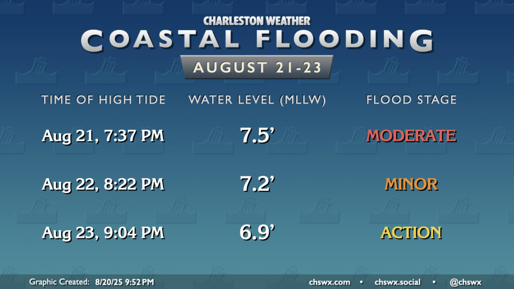
Erin has made its closest approach to the Lowcountry, and will begin to accelerate to the northeast on Thursday. Still, after a 7.61′ MLLW high tide Wednesday evening, minor to moderate flooding should once again take place with Thursday evening’s high tide. Expect water levels to peak roughly around 7.5′ with the 7:37 PM high tide. This should close a few roads once again, so be ready to reroute if needed. Friday’s high tide will peak a little lower, generally in minor flood stage. Saturday’s high tide will get close to the 7′ threshold, but should not cause widespread issues beyond the most vulnerable areas around Gadsden Creek.
Friday & the weekend: Turning unsettled again, but also cooler
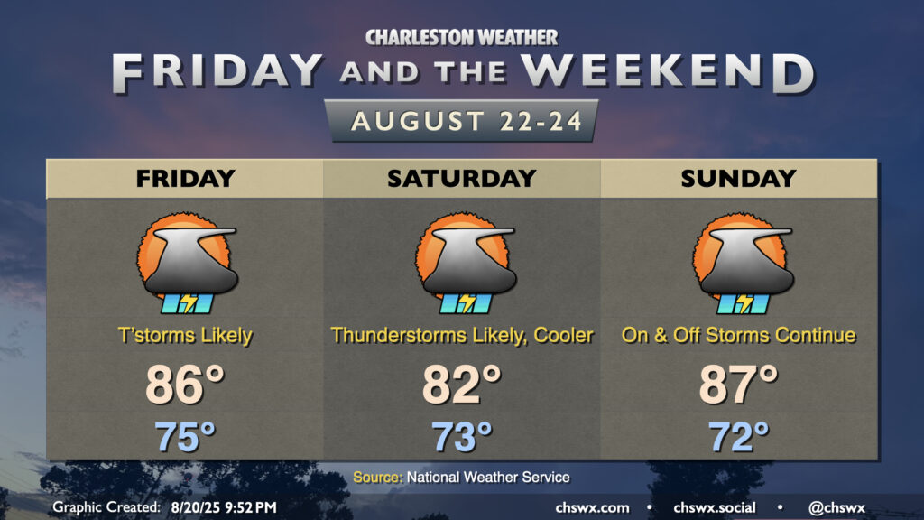
Unsettled weather returns to the Lowcountry for Friday and the weekend as the aforementioned front that approaches the area Thursday night stalls out to our south on Friday. This will keep showers and thunderstorms in play at times, though it shouldn’t rain all day at any one location, either. Heavy rain will be possible in some spots, but the risk for severe weather is low. The cloud cover and shower activity should keep temperatures held to the 80s, with the coolest day coming on Saturday as highs may not climb too far beyond the low 80s.
Another round of cooler and drier air moves in early next week, with dewpoints falling to the mid-60s by mid-week, which should feel pretty nice as we close in on September. (Hard to believe!)
Tropics: Two other areas to watch, but no imminent concerns
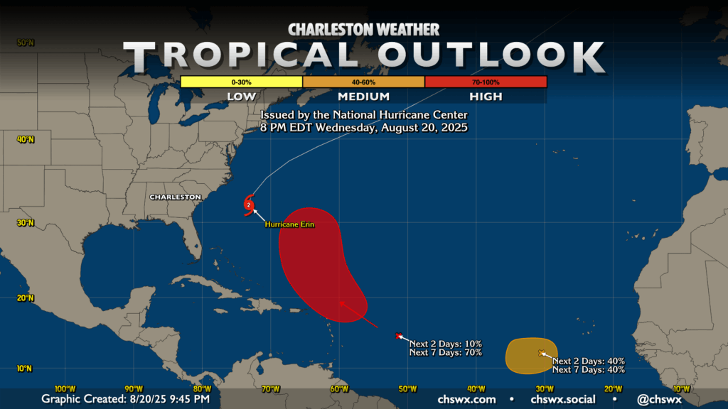
In addition to Erin, the National Hurricane Center continues to monitor two areas for tropical development over the next several days. The first area, which is just a few clicks left of 50°W as of the 8PM tropical outlook, should develop into a tropical cyclone over the weekend as it turns northwest and eventually northward near the Leeward Islands. This storm isn’t a concern for the Lowcountry, but might be something for our friends in Bermuda to keep an eye on.
The second area, located to the southwest of the Cabo Verde Islands, has a short window to become a depression or weak tropical storm before moving into more unfavorable conditions. NHC gives it a 40% chance to develop over the next few days, but it’s not something to be overly concerned about here, either.
Follow my Charleston Weather updates on Mastodon, Bluesky, Instagram, Facebook, or directly in a feed reader. Do you like what you see here? Please consider supporting my independent, hype-averse weather journalism and become a supporter on Patreon for a broader look at all things #chswx!