Rest of the work week: One more front, then much more sun
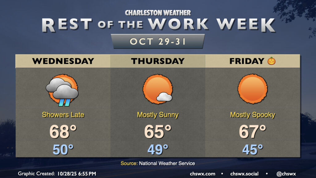
After the coolest day since late February — the high at the airport only peaked around 57° — we’ll turn warmer on Wednesday as an approaching cold front scours out the wedge of high pressure that brought us a dreary, drizzly Tuesday. We’ll start Hump Day around 50° under mostly cloudy skies once again. A warm front lifting northward will push through the area later in the afternoon, and it’s that warm front along with some breaks in the cloud cover which will help us warm to the mid-to-upper 60s later in the day. Shower chances will return in the evening through the overnight as a band of rain ahead of the cold front moves by.
Showers should depart by the time most of us get Thursday underway. We’ll start in the upper 40s to around 50° once again, warming to the mid-60s in the afternoon with much more in the way of sunshine than we’ve seen so far this week. Clearer skies overnight Thursday will allow Halloween to start a little cooler, generally in the mid-40s in the metro (with lower temperatures possible further inland as well as in some more rural areas). Unfettered sunshine will send temperatures in the mid-to-upper 60s in the afternoon. Trick-or-treaters and their accompanying guardians (where applicable) should expect temperatures to fall into the 50s around and after sunset.
Weekend outlook: More sun, gradual warming
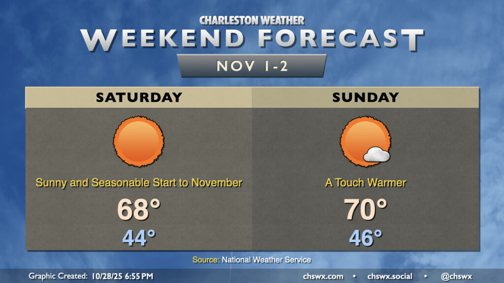
Below-normal temperatures continue into the weekend, kicking off November in seasonably cool style. We’ll start each day in the mid-40s. Temperatures on Saturday will warm to the upper 60s, while we should touch 70° again on Sunday as a subtle warming trend continues. There will be plenty of sunshine to be had, but after clocks fall back on Sunday, we’ll need to get it in before 5:30.
Tropics: Hurricane Melissa makes history — for all the wrong reasons
Hurricane Melissa made landfall in Jamaica today, and the preliminary numbers suggest it may be the strongest landfall in the Atlantic basin since the 1935 Labor Day hurricane moved across the Florida Keys. Melissa made landfall with maximum sustained winds of 185 MPH and a minimum central pressure of 892mb, tying the aforementioned Labor Day hurricane for strongest landfall in the Atlantic basin by wind and lowest pressure. Given the strength of the storm, it will take time to understand the full extent of the impact in Jamaica. As you browse your feeds, be wary of AI images and social media posts from unvetted sources, especially in the early aftermath.
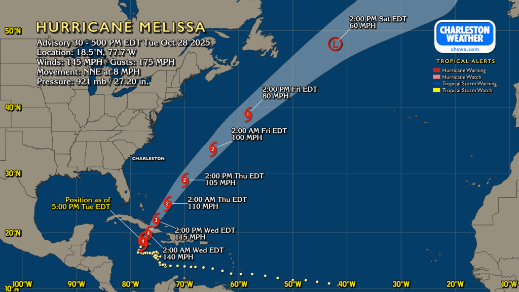
As of the 5PM advisory, Melissa had 145 MPH maximum sustained winds with gusts to 175 MPH. It was moving NNE at 8 MPH, and pressure was up to 921mb after land interaction weakened the storm. At this writing, though, Melissa is back over water and seems to be regaining organization quickly as it sets its sights on eastern Cuba for a second landfall overnight. From there, Melissa will have impacts on the Bahamas as it accelerates northeastward, giving Bermuda a brush later this week before finally making an extratropical transition by Saturday. There are no concerns locally for Melissa, though some wave action may not be off the table as the storm moves by.
Follow my Charleston Weather updates on Mastodon, Bluesky, Instagram, Facebook, or directly in a feed reader. Do you like what you see here? Please consider supporting my independent, hype-averse weather journalism and become a supporter on Patreon for a broader look at all things #chswx!