Friday & the weekend: Plenty of sunshine, increasingly warm
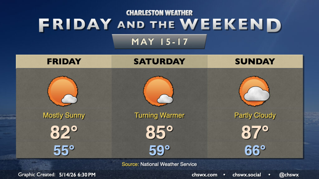
Generally quiet weather will continue for Friday and the weekend with high pressure in control. If you liked Thursday’s weather, we have more of that comfortable warmth in store for Friday. We’ll start the day a bit below normal — generally mid-50s — and warm to the low 80s in the afternoon.
High pressure slips into the Atlantic for the weekend, turning temperatures warmer and the air a little more humid for the weekend. After one more start in the 50s, temperatures head to the mid-80s on Saturday afternoon. Sunday starts much warmer than Saturday will — expect mid-60s — before warming into the mid-to-upper 80s in the afternoon under partly cloudy to mostly sunny skies.
Looking for rain? It might be another week before the next mentionable rain chance with high pressure staying firmly in control for a few more days.
Finally, the high astronomical tide with the new moon will increase the risk for minor coastal flooding with the evening high tides beginning Friday. Keep an ear out for possible Coastal Flood Advisories from the National Weather Service.
Follow my Charleston Weather updates on Mastodon, Bluesky, Instagram, Facebook, or directly in a feed reader. Do you like what you see here? Please consider supporting my independent, hype-averse weather journalism and become a supporter on Patreon for a broader look at all things #chswx!