The week ahead: Heat stays on
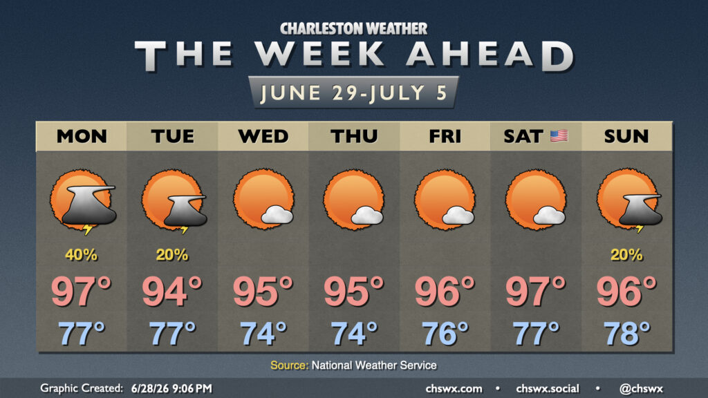
Summer heat and humidity continues as we close June and start July, with sustained heat continuing into the Fourth of July weekend.
Afternoon shower and thunderstorm chances will hang around for Monday, which should be another very warm day after reaching 98° on Sunday. We’ll get close to record highs, though the record of 99° set in 1998 may be just out of reach. Scattered thunderstorms will be possible again in the afternoon as a backdoor front pushes into the area from the north, though not everyone will see a storm.
The front tames the heat slightly as it clears the area early Tuesday, but we’ll still be plenty warm with highs running in the mid-90s once again. There is a slight chance of an isolated shower or thunderstorm along the seabreeze, but most of us will stay dry.
From there, another strong ridge of high pressure builds in across the eastern half of the continental US, driving a continued string of warm and humid days with sparse rain chances at best. Temperatures will run in the mid-to-upper 70s each morning, warming to the mid-90s each afternoon. Independence Day in particular is looking even a tick warmer, with lows in the upper 70s to perhaps 80° at the coast warming to the upper 90s in the afternoon. Most models start to break the ridge down over the weekend, though, and that may allow for a couple afternoon thunderstorms on Sunday. However, hot and rain-free conditions look to be the rule. We’ll need to monitor for possible Heat Advisories, especially as we head into the Fourth of July.
Tropical update: Low chance for homegrown development later this week
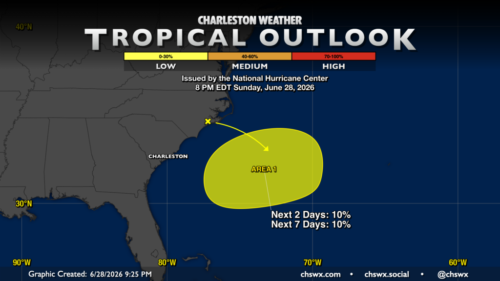
A wave of low pressure could develop along the aforementioned front as we get into midweek, and there has been a little ensemble support in recent days of this spot developing into something a little more tropical as it emerges across the Gulf Stream. Recent guidance, though, seems to be backing off this solution a bit, and the National Hurricane Center only gives the suspect area a 10% chance to develop over the next week as a result. We’ll keep an eye on this, especially given the proximity of the holiday weekend, but right now no impacts are expected.
Follow my Charleston Weather updates on Mastodon, Bluesky, Instagram, Facebook, or directly in a feed reader. Do you like what you see here? Please consider supporting my independent, hype-averse weather journalism and become a supporter on Patreon for a broader look at all things #chswx!