The week ahead: Climatological fall begins with temperatures back to the 90s
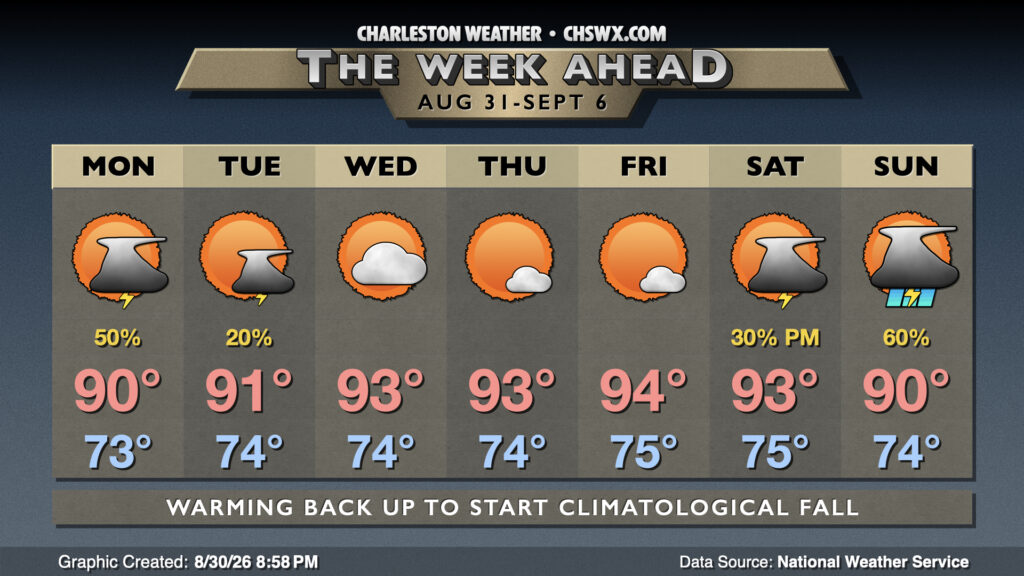
A very warm climatological summer — perhaps a top-three warmest on record — comes to an end on Monday as we roll into September. It won’t feel like fall, though, as temperatures head back to the mid-90s as clouds and showers give way to sunnier skies.
We will stay a bit on the unsettled side on Monday, though, as we still have a bit of a trough of low pressure hanging on aloft. At the surface, we’ll see showers and thunderstorms firing across the area in the morning propagating inland throughout the day as the seabreeze does its thing. Temperatures will start in the mid-70s, warming to around 90° in the afternoon. Not everyone sees rain, but a few of you could see some heavy rain, so keep an eye out for possible isolated spots of flooding.
As we get into midweek, high pressure will begin to ridge back in aloft. That’ll help suppress shower and thunderstorm chances while temperatures will head back into the mid-90s each afternoon. Heat indices won’t quite be as intense as we saw during August, but some readings above 105° can’t be totally ruled out, especially during the second half of the week.
Shower and thunderstorm chances will tick back up for the weekend as a backdoor front looks to sag southward into the area. Wait and see how this develops, but as usual for the warm season, a whole-day washout is highly unlikely.
Tropics: Area in the Gulf looking close to development; remnants of Dolly hanging tough, too
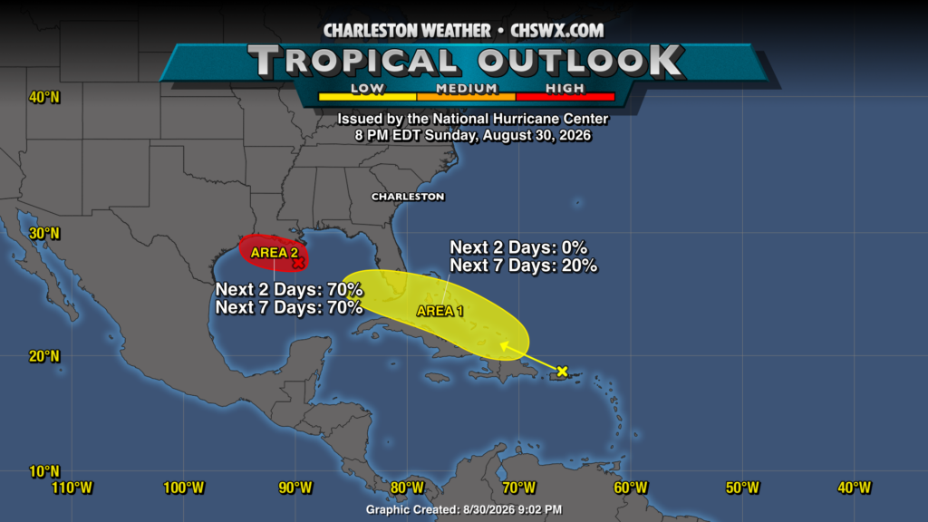
The tropics continue to be worth monitoring closer to the continental US as the remnants of Dolly as well as a second area of low pressure in the Gulf continue to hang on — and, in some cases, thrive. The Gulf area in particular looks on the verge of becoming a tropical cyclone, with satellite and scatterometer passes indicating a closed circulation. NHC officially gives it a 70% chance to develop, though it wouldn’t shock me to see it be labeled a Potential Tropical Cyclone soon.
Dolly’s remnant wave continues to bring some rain to Puerto Rico and Hispaniola as it continues to move northeast. It, too, may get into the Gulf later this week, where it may have an outside shot of developing, though those odds remain around 20%. Overall, though, there are no imminent concerns for our neck of the woods, and the rest of the tropics remain quiet courtesy of El Niño.
Follow my Charleston Weather updates on Mastodon, Bluesky, Instagram, Facebook, or directly in a feed reader. Do you like what you see here? Please consider supporting my independent, hype-averse weather journalism and become a supporter on Patreon for a broader look at all things #chswx!