The week ahead: Unsettled and warm start, but seasonable conditions arrive this weekend
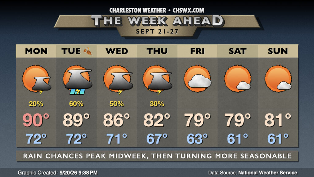
The week ahead gets off to a hot, humid, and unsettled start, but by the end of the week, temperatures will be more befitting of — if not a few clicks below — what we’d expect from late September.
First, though, we need to get through the start of the week, which will stay warm and occasionally unsettled as a humid airmass persists for a few more days while an upper low that began its weekend over Florida migrates northward. Showers and thunderstorms will be possible at times on Monday, but coverage should generally be isolated and short-lived much like we saw on Sunday, starting at the coast and progressing inland with time. Highs Monday peak around 90° after a muggy start in the low 70s.
The best chances for showers and thunderstorms arrives Tuesday as a front starts to encroach southward along with the influence of the aforementioned upper low. With plenty of moisture available, heavy rain will be a concern, and the presence of the upper low will destabilize the atmosphere a bit more as well, so a strong to severe storm can’t be ruled out. Highs should once again peak in the upper 80s to around 90° before storms get involved. The autumnal equinox will then occur a little after 8PM, marking the beginning of astronomical fall. (Climatological fall began on September 1.)
From there, rain chances begin to diminish as the front slides southward and cooler and drier high pressure begins to build in from the northeast. We’ll keep a thunderstorm chance around Wednesday into maybe Thursday depending on the timing of the drier air, but the trend will solidly be turning cooler as we head into the weekend. Highs in the mid-80s on Wednesday drop to the low 80s on Thursday, and may not exceed 80° Friday and Saturday. As low pressure deepens off the Mid-Atlantic coast this weekend, drier air will continue to surge into the area, dropping dewpoints into the 50s and potentially allowing lows to follow suit as well. It’s been a while since we saw a low below 60°; the last such occurrence was on June 4, when the low dropped to 57°.
Tropics: TS Fay forms near the Azores, approaches hurricane strength
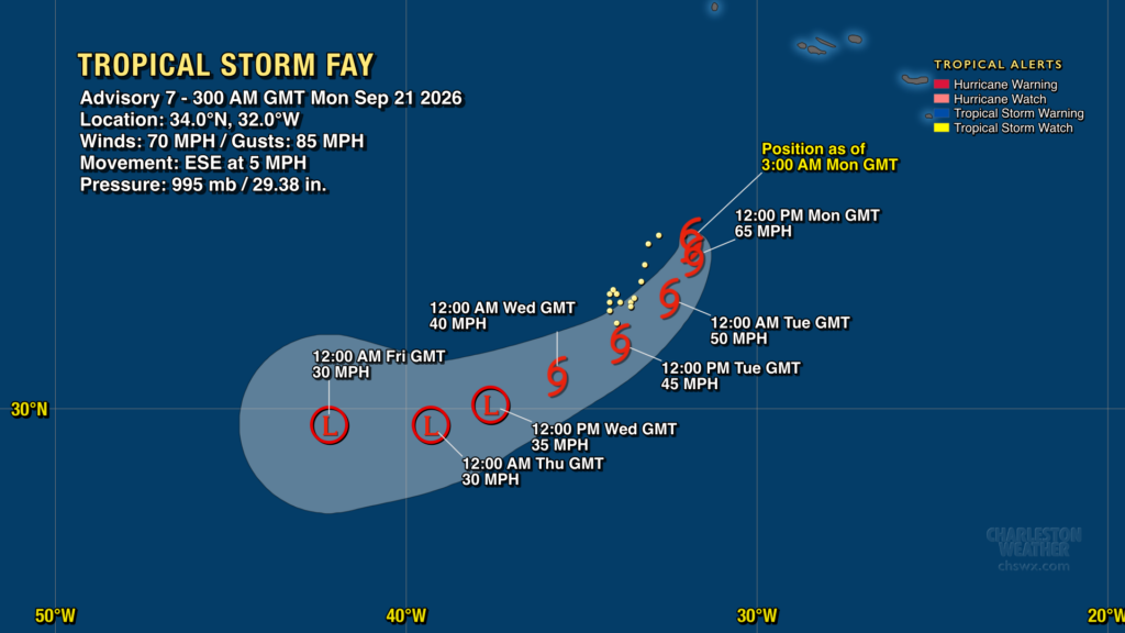
Finally, Tropical Storm Fay formed over the weekend near the Azores, posing no threat to land. It does, however, pose a threat to 2026’s hurricane-free stretch, which is the longest such stretch in the satellite era (starting in 1960). While not explicitly forecast, there is a chance it may become the season’s first hurricane, but if it does, it won’t last long as it moves eastward into more hostile conditions for tropical cyclone survival. By Wednesday, it should be a remnant low. Elsewhere in the tropics, we remain eerily quiet as El Niño continues to impart very hostile conditions for tropical cyclone genesis on the Atlantic. (Not mad about it, to be clear.)
Follow my Charleston Weather updates on Mastodon, Bluesky, Instagram, Facebook, or directly in a feed reader. Do you like what you see here? Please consider supporting my independent, hype-averse weather journalism and become a supporter on Patreon for a broader look at all things #chswx!