Jared Smith founded @chswx on Twitter in 2008 as an experiment in disseminating weather data through social media. In the ensuing decade-and-a-half, @chswx has provided live coverage of tropical cyclones, tornadoes, severe weather, and even a couple bouts of winter weather to the good people of Charleston, SC.
Well, today was supposed to feature a lull in the shower and storm action, with more isolated coverage…and then it rained for five hours, flooding downtown Charleston again while 3-5″ of rain dumped on Johns Island and West Ashley. This was due to the combination of a stalled front and outflow from a thunderstorm cluster that developed to our northwest. Add in a little upper-level energy and you have a very, very soggy Thursday afternoon. Thankfully, the bulk of today’s rain is over and we should largely dry out overnight (though with fog a distinct possibility).
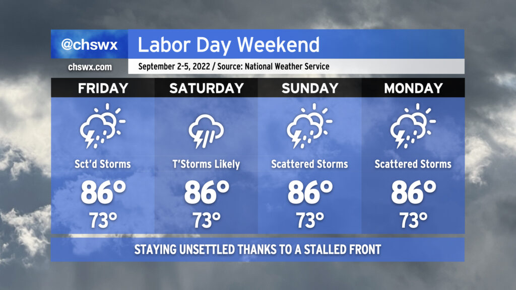
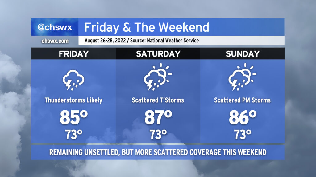
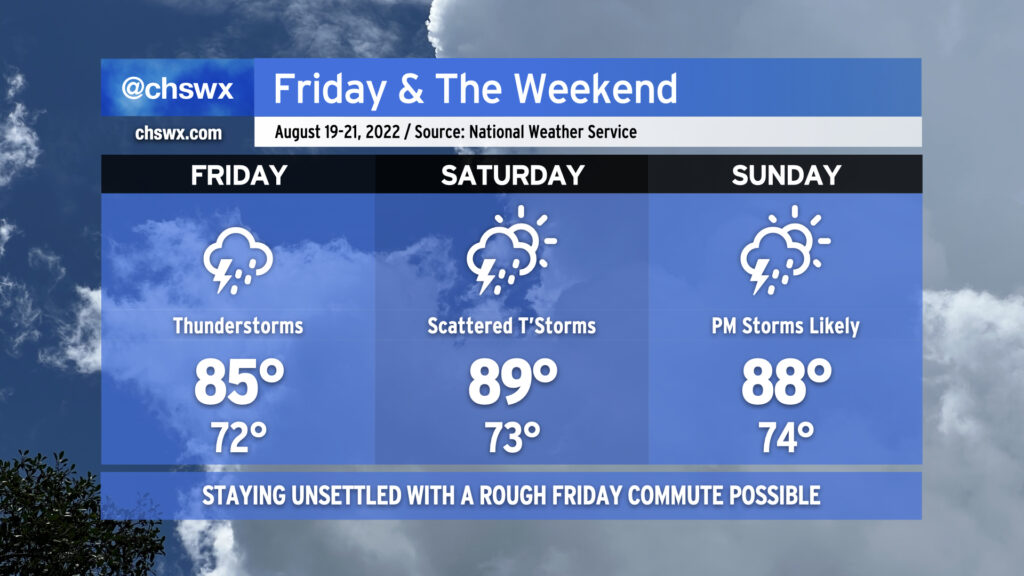
As we head into Friday, scattered storms remain in the forecast as the ever-present front remains close by. The impact on our weather will largely be driven by how far south it slips tonight into tomorrow. Right now, the expectation is that the greatest concentration of storms will be to our south and west, but I do anticipate that we’ll see a few more downpours tomorrow across the metro area, perhaps again having impacts on the evening commute.
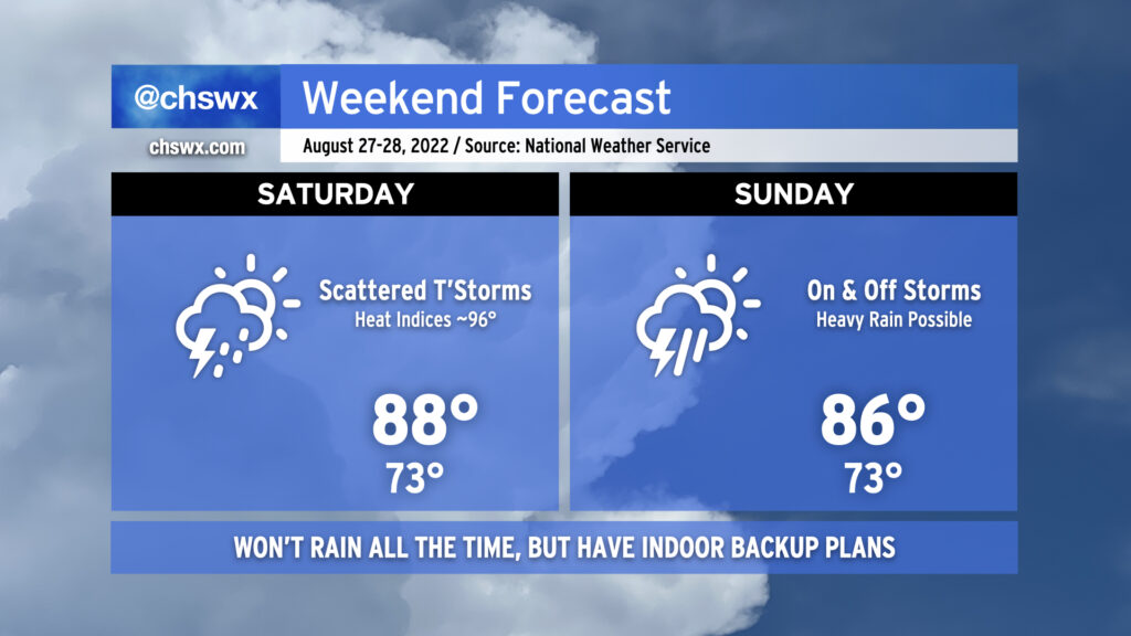
Shower and storm coverage is expected to tick up a little bit more Saturday as onshore flow becomes a little more convergent at the surface. That’ll be the day with the greatest potential for persistent rainfall (at least as currently forecast). There is a little model disagreement with where the surface front will be, though, and so that’ll drive a little uncertainty. Heading into Sunday and Labor Day, rain chances continue to persist, with scattered coverage expected as a coastal trough develops and hangs around. This doesn’t look to be a full-day washout for Labor Day, but be ready to move outdoor activities inside.
With the persistent risk of scattered storms and the ensuing cloud cover, highs should stay in the mid-80s each day after starting in the lower 70s. This is around, if not a touch below, early September normals.
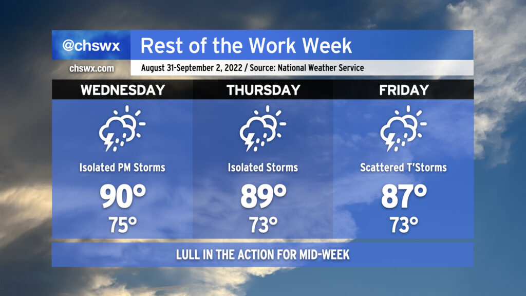
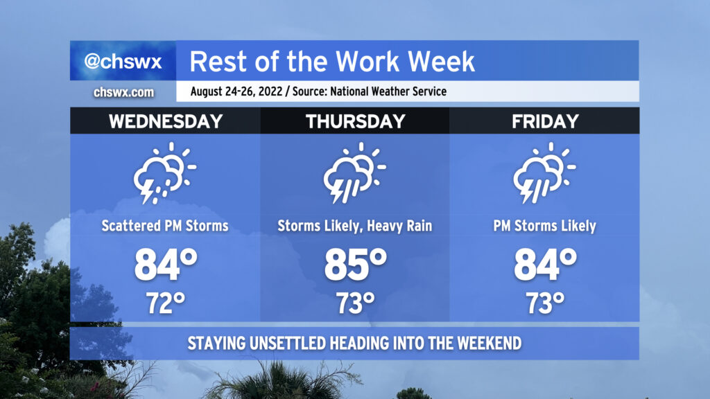
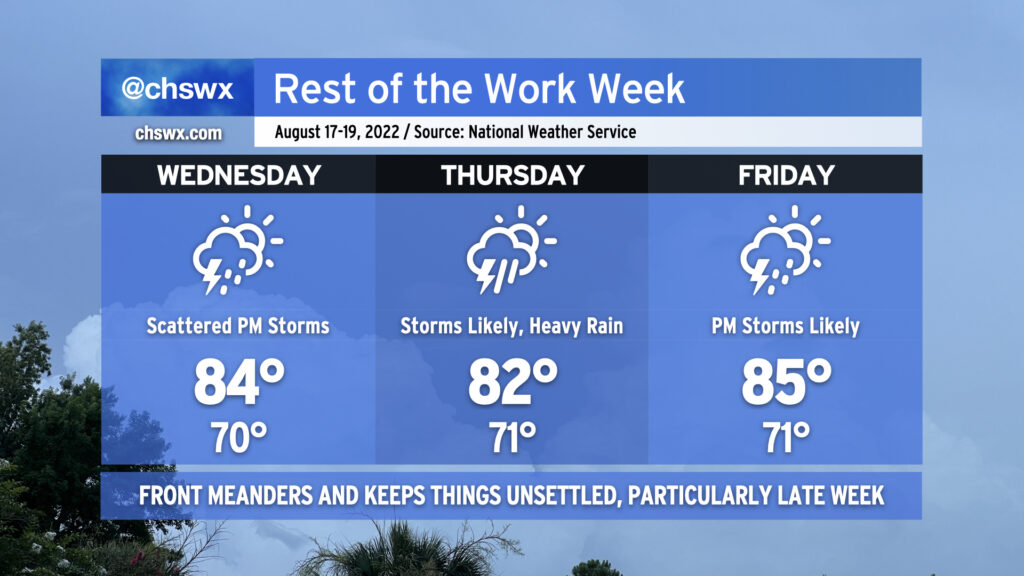
As we head into mid-week and look to round the corner toward Labor Day weekend, we’re going to see a reduction in shower and thunderstorm coverage for a few days as some drier air aloft works in from the north and west. We’ll keep isolated to scattered shower and thunderstorm chances in the forecast as those probabilities won’t be totally eliminated, particularly near the coast, but we shouldn’t see the sustained flooding rains that have been a concern the past couple days. Areas further inland could even see a rain-free couple days, especially on Thursday as a front clears the area and stalls to our south.
As rain chances diminish, temperatures turn back up to a little above normal as we close out August and enter September. Expect highs around 90° for Wednesday; mix in the plentiful humidity and it’ll feel closer to 100-102°. Thursday will run pretty warm, too, with highs around 90° and heat indices in the upper 90s once again expected. Rain chances begin to tick back up on Friday, and that’ll lead to high temperatures topping out a little lower than the previous couple days, generally in the mid-to-upper 80s.
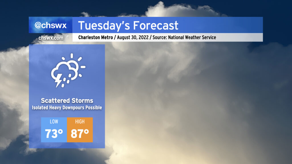
After a torrential deluge that closed numerous streets both in downtown Charleston as well as North Charleston, we should see a little less coverage of showers and thunderstorms for Tuesday, but more heavy rainfall will be possible. We could once again see some wet weather for tomorrow morning’s commute as another round of showers and storms skirts up the coast. Then, a more typical afternoon round of scattered showers and storms should fire up along the seabreeze as temperatures are expected to climb to the mid-to-upper 80s. Given the drenched soils from Monday’s rains, it may not take much to cause additional flooding problems on Tuesday where heavier rain falls, so that’ll certainly be something worth watching. Flooding rain, though, should certainly not be as widespread as we saw today.
We’ll continue to see a decrease in coverage as the week goes on, though scattered showers and storms will remain possible each afternoon, with a few stronger storms not out of the question Wednesday into Thursday. An uptick in coverage is possible Friday into Saturday depending on where a cold front stalls out — stay tuned for refinements.
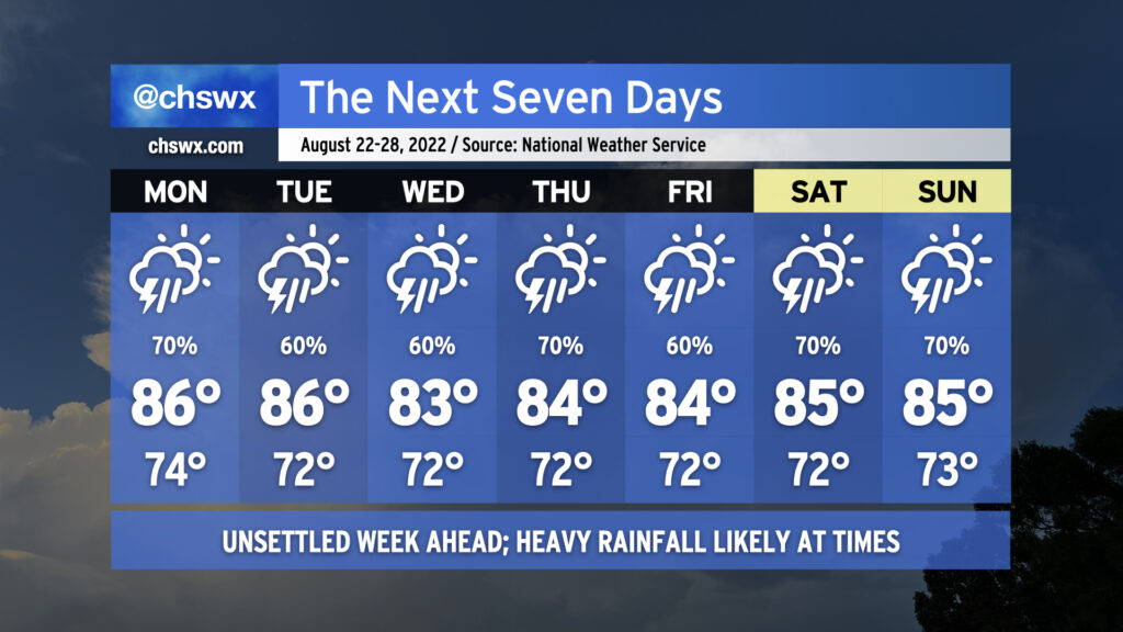
More wet weather is on the way as we remain in a rather unsettled pattern heading into the first days of September (and meteorological fall!)
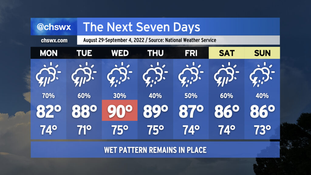
We’ll likely start Monday with showers and maybe some thunderstorms in the metro area as offshore storms make a run to the coast. Be ready for a somewhat complicated commute due to rain. It’ll be worth watching downtown around high tide just before 10am, too, for the potential for heavy rain to combine with said tide to possibly produce some street flooding. Storms and their associated pockets of heavy rain will continue to spread inland throughout the day. Rain and cloud cover will keep temperatures suppressed to the low 80s.
We stay unsettled heading into Tuesday as a front moves toward the area. Thunderstorms will become likely once again in the afternoon, though temperatures will have a little more time to rebound into the upper 80s. Expect more scattered coverage Wednesday as a little drier air aloft moves in, which will allow temperatures to head into the low 90s in the afternoon ahead of the front. The front moves by Thursday and stalls out to the south, which will help keep moisture in place and the risk for showers and thunderstorms in the forecast as we head into the Labor Day weekend. As is customary for late summer, there will not be any day that’s a total washout — just have backup plans for any outdoorsy things you might have going on.
Our weather looks to stay somewhat unsettled this weekend as we remain within a somewhat stormy pattern across the eastern US. If I’m picking a day for outdoor activities, I like Saturday; a little drier air will punch down into the area from the north and should help shunt the better rain chances southward. That being said, scattered showers and a few thunderstorms should still develop along and ahead of the seabreeze in the afternoon, so stay on guard if you do have outdoor plans. It’ll be a bit warmer than it’s been the past few days, with highs reaching into the upper 80s courtesy of a little bit more sunshine than we’ve seen recently.
Sunday should see a little greater shower and storm coverage as more moisture spreads back into the area. The best chance for showers and storms will be in the afternoon, but guidance suggests the potential for rain as early as mid-morning. Don’t write off any outdoor plans just yet, though — trends will become more established tomorrow. Highs will run a touch cooler with more cloud cover and storms expected — generally expect mid-80s in the afternoon.
The pattern looks to stay generally unsettled heading into the last weekend of August, though some subtle changes will help reduce coverage at least a little on Saturday and Sunday.
Showers and thunderstorms remain likely particularly Friday afternoon and evening as a front remains stalled just offshore and energy aloft pivots into the area. We continue the risk for heavy rain with precipitable water values well in excess of 2″ expected to persist — plenty of moisture for deep convection to wring out. Watch for ponding of water on roads or even isolated bouts of flooding.
Slightly drier air will then poke in from the north on Saturday into Sunday. This should have the effect of scattering out shower coverage a little bit more, particularly on Saturday. However, the area won’t totally get off scot-free when it comes to rain this weekend, so be sure your outdoor plans have an indoor backup just in case.
Temperatures will remain a few clicks below normal for late August as cloud cover and rainfall stick around. Generally, we should expect lows in the low 70s each morning (running a little warmer near the coast thanks to warm sea-surface temperatures) followed by highs in the mid-80s in the afternoons.
Unsettled weather looks to continue as we close out the work week. Wednesday will represent a little break from more of the widespread rain that we’ve seen of late. However, the atmosphere is still plenty juiced, and daytime heating will help fire off scattered showers and thunderstorms as a result. Bouts of heavy rain are expected, and more flood advisories are possible.
Rain chances head back into the likely category Thursday and Friday as another front moves into the area along with some energy rippling in aloft. Numerous to widespread showers and thunderstorms should redevelop each afternoon, with the threat of heavy rain and maybe some flooding continuing to loom. Exact timing on where and how much it will rain is impossible to know this far out — just know that some of you could see some very heavy rain, while others may see lighter amounts overall.
Temperatures will remain suppressed to the mid-80s each afternoon thanks to cloud cover and nearby showers and storms. Mix in humidity, though, and it’ll feel like the low to mid-90s especially if and when the sun peeks out from time to time.
Looking for rain relief this weekend? I wouldn’t bet on it; we’ll still see decent coverage of showers and thunderstorms especially each afternoon heading into next week. At least temperatures will remain capped in the mid-80s, which doesn’t feel so bad at this point in the year.
We’ve got an on-again, off-again soggy kind of week in store as an unsettled pattern characterized by a persistent mid-level trough over the eastern US stays firmly in place. Before it’s over, many spots could see another 2-3″+ of rain on average, with locally heavier amounts depending on where downpours set up. The greatest risk of thunderstorms will be the afternoon and evening hours each day, but the atmosphere will be such that a shower or storm could happen at pretty much any time. As the week goes by and soils get soggier, we will see an uptick in the flood threat as well.
Suffice to say, this is one of those weeks where we could see another Downtown flooding event or two. It’s almost impossible to pinpoint what day this could happen, as these events are often driven by smaller processes that are impossible to model accurately with any sort of lead time. Keep a close ear to forecast updates, and monitor for possible Flood Advisories from the National Weather Service.
The one upside to rain and cloud cover? Temperatures will be held into the mid-80s for much of the week, though any sunshine that breaks out immediately after a storm will make things feel steamy.
Unsettled weather will continue this weekend as the lingering front remains a thorn in our side. Friday morning could be a particularly tricky commute as there’s the potential for some heavy rain to be moving through the area around that time. Fortunately, the commute will coincide with low tide, but whenever we’re talking heavy rain we’ll want to keep an eye on the vulnerable areas, such as downtown Charleston, Summerville, and West Ashley near Church Creek (to name a few). Showers and thunderstorms will lift north of the area with the front as the day goes on, but more storms should fire in the afternoon as the seabreeze gets going. Temperatures will generally run in the mid-80s.
With the front having lifted north, warmer weather returns to the area for the weekend. Temperatures top out in the upper 80s to around 90° on Saturday with scattered thunderstorms developing along and ahead of the seabreeze, possibly starting as early as the late morning hours. On Sunday, we’ll stay unsettled with scattered showers and thunderstorms expected particularly in the afternoon and evening hours, when storms could turn a little more numerous. Highs once again will top out in the upper 80s. Overall, not the best weekend of weather, but there will be dry times, too — rarely, if ever, do we see total washout days in the summer.
Unsettled — but somewhat cooler — weather continues this week, particularly Thursday into Friday as areas of low pressure along a lingering front as well as impulses around a persistent upper trough help enhance rain chances across the area.
Wednesday will be the driest of the set. As of this writing, the front is driving southward into Georgia, and should stay to our south for much of the day, keeping us in cooler and slightly drier air. While this won’t totally suppress the risk for afternoon showers and thunderstorms, it certainly will keep coverage generally isolated to scattered at best for the first day of school in Charleston County. Highs will top out in the mid-80s, which should make for a reasonably nice day all things considered (though dewpoints around 70° will still feel muggy).
Rain chances begin to ramp up late Wednesday night into Thursday as surface low pressure moves along the front, drawing the boundary a little more north. At the same time, the trough aloft pivots enough to put us in the right entrance region of a jet streak, helping to enhance lift. This combination will make for an unsettled Thursday, with scattered to numerous thunderstorms expected across the area. Heavy rain will be a concern, and we’ll need to keep a close watch for isolated flooding potential. The widespread rain and onshore flow just behind the stalled front should keep Thursday’s high temperatures suppressed to the low 80s.
Friday will run a touch warmer (mid-80s) with a little less coverage of storms to start the day, but showers and thunderstorms become likely in the afternoon after mixing some daytime heating in along with the specter of additional disturbances rounding the base of the upper trough and the persistent stalled front. Heavy rain will once again be a concern with the strongest storms.
This unsettled pattern looks to persist into the weekend as the front continues to meander and weaken, while temperatures turn warmer, closer to mid-August norms.