Jared Smith founded @chswx on Twitter in 2008 as an experiment in disseminating weather data through social media. In the ensuing decade-and-a-half, @chswx has provided live coverage of tropical cyclones, tornadoes, severe weather, and even a couple bouts of winter weather to the good people of Charleston, SC.
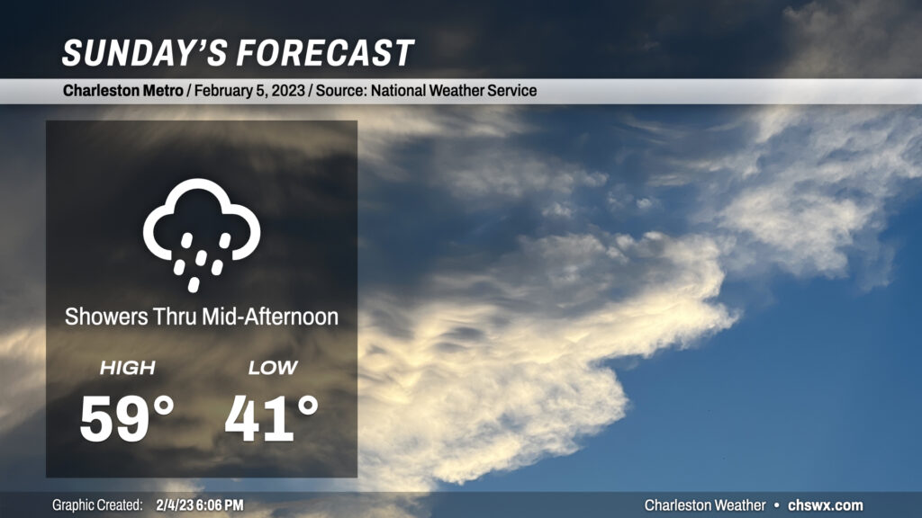
Expect to wake up to some showers in the area on Sunday as a coastal trough sharpens and moves ashore. Temperatures will run warmer in the morning thanks to increasing cloud cover, with lows bottoming out in the low 40s (as opposed to the low 30s this morning). High temperatures will approach 60°, several degrees warmer than we felt today (Downtown didn’t even make it into the 50s!). Shower chances look to peak by midday before tapering off later in the day. We’ll close the day with quieter weather and maybe a few peeks of sun before it’s all said and done. About a quarter-inch of rain is expected — nothing terribly out of bounds once again, and still quite useful given ongoing dryness.
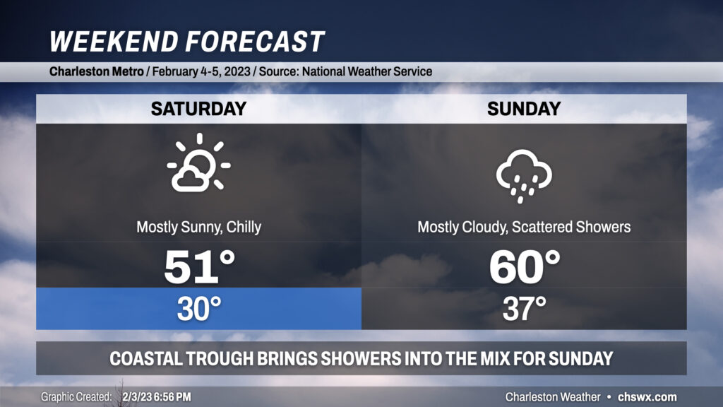
We get off to a very chilly start on Saturday, with many of us dipping into the upper 20s to around 30° in the morning under clear skies. Northeast winds around 10 mph or so will make it feel closer to the low 20s, so you’ll definitely want those layers if you’ve got plans Saturday morning. Despite full sunshine, highs will only top out around 50° given the very chilly airmass in place.
The really chilly weather will not stick around, though. Clouds will start to increase overnight Saturday into Sunday as high pressure slips offshore and a coastal trough sharpens. This trough could trigger some scattered showers for a decent bit of the day on Sunday, though it won’t rain all day in any one location, and showers should come to an end by evening. Temperatures on Sunday will bottom out in the mid-to-upper 30s before warming into the low 60s in the afternoon as some warmer maritime air makes it ashore.
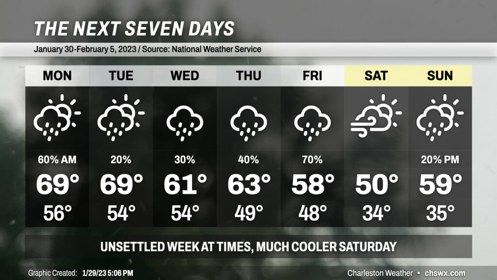
From there, we’ll be back into a warming trend with 70s possible by Wednesday, and our next shower chances look to arrive later Thursday into Friday.
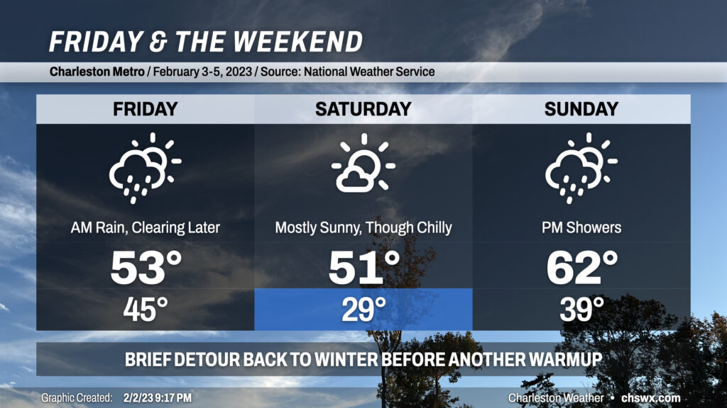
Showers overnight will continue into Friday morning before tapering off in the afternoon. We could see some peeks of sun before Friday’s all said and done, which would be helpful given that highs are only expected to top out in the low 50s. We stay chilly heading into Saturday, with lows in the upper 20s expected across the metro in the morning before temperatures only rebound into the low 50s despite mostly sunny skies. We turn warmer Sunday with highs in the low 60s, but shower chances return in the afternoon as a coastal trough/front sharpens. Overall, if you can deal with some chilly air, Saturday is your best outdoors day, though Sunday morning into early afternoon should be pretty good as well.
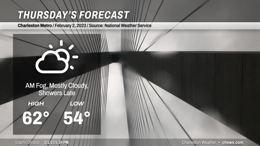
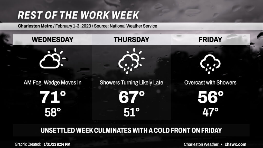
After a record high downtown (77°, breaking the record of 76° set in 1916 and tied in 1950) and just falling short at the airport (81°), temperatures are turning significantly cooler across the area as a wedge front sinks southward tonight. This will result in mostly cloudy conditions for Thursday, with highs running almost 20° below where they did today. Expect some showers to creep back into the area later in the day, with better rain chances settling in overnight into Friday. (Let’s just hope we don’t get caught in a temporal loop on this Groundhog Day.)
After a soggy couple days, we get a respite from some of the rain on Wednesday as we sit between storm systems and high pressure sinks south across the area. Fog may be an issue in the morning once again, so be ready with the low beams and a little extra time to get where you’re going. Temperatures should peak in the low 70s in the afternoon before cooler high pressure and an associated wedge front press southward across the area later in the day. It remains to be seen just how far south the wedge can get, but expect it to help cool temperatures to around 50° in the morning on Thursday.
I’d consider mid-60s to be a best-case scenario for temperatures on Thursday as it will be highly dependent on the position of the wedge front. It is expected to lift a little more northward as a warm front during the day Thursday with shower chances throughout the day. However, rain chances tick up later in the day into the overnight, and the rain falling into the cool wedge should strengthen it and allow it to sink back into the Lowcountry by evening. We stay wedged in Friday as showers move across the area for a majority of the day ahead of a storm system. It’ll be chilly on Friday, with lows in the upper 40s giving way to highs in the mid-50s at best with rain blanketing the area as low pressure traverses the Gulf Coast and moves across the Florida panhandle, staying south of us and keeping us in the cool sector.
Chilly weather continues into Saturday, though with a much-needed shot of sunshine before another storm system begins to affect the area on Sunday. For now, though, keep the rain gear nearby!
We’ve got more gray weather in store for a good bit of Tuesday, but there may be a little reprieve later in the day before showers return to the picture around sunset. We’ll start the day with fog across the area, which may turn a bit dense at times. A shower or two can’t be totally discounted, either. Be ready for some delays on the morning commute as a result.
We will get a break from the rain and fog around midday. There’s a chance we could see some peeks of sun in the afternoon, which would be welcomed. This could help drive temperatures into the upper 60s within a rather humid airmass. Scattered showers may break back out, particularly after sunset.
Bottom line: Keep the rain gear nearby, though you shouldn’t need it as much as you did on Monday.
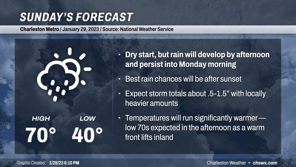
We’re not looking at a total washout for much of the day, but expect showers to develop later in the day on Sunday as a warm front pushes ashore along with some mid-level energy rippling about. Before rain sets in, temperatures should top out around 70°, making for perhaps some short sleeves weather for a time. Shower chances increase around sunset, peak overnight, and will linger into Monday morning. This could be another decent soaking for us, especially given moderate drought conditions across a good bit of the Tri-County area — expect storm totals between .5-1.5″ across a good chunk of the area with locally higher amounts possible. The good news is that no flooding issues are anticipated, and there’s no severe weather risk, either.
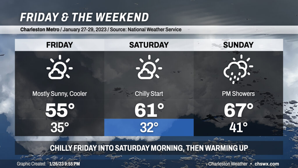
Cool weather will kick off Friday and the weekend as we sit under the influence of high pressure for a couple days before it shuffles back offshore later Saturday into Sunday. Expect lows in the mid-30s on Friday before warming just into the mid-50s despite plenty of sunshine; this is due to a trough axis in the mid-levels passing by to the north. We’ll see this feature give way to more zonal (west-to-east) flow as we get into Saturday, which will start around freezing but will rebound into the low 60s as high pressure begins to move east of the area. Temperatures — and dewpoints — then climb quickly on Sunday ahead of a storm system that’ll kick off rain showers in the afternoon, with the best chances for rain arriving late Sunday into Monday. Highs on Sunday should top out in the mid-to-upper 60s, foretelling a fairly warm end to January with highs next week approaching the 70° mark to close out the first month of 2023.
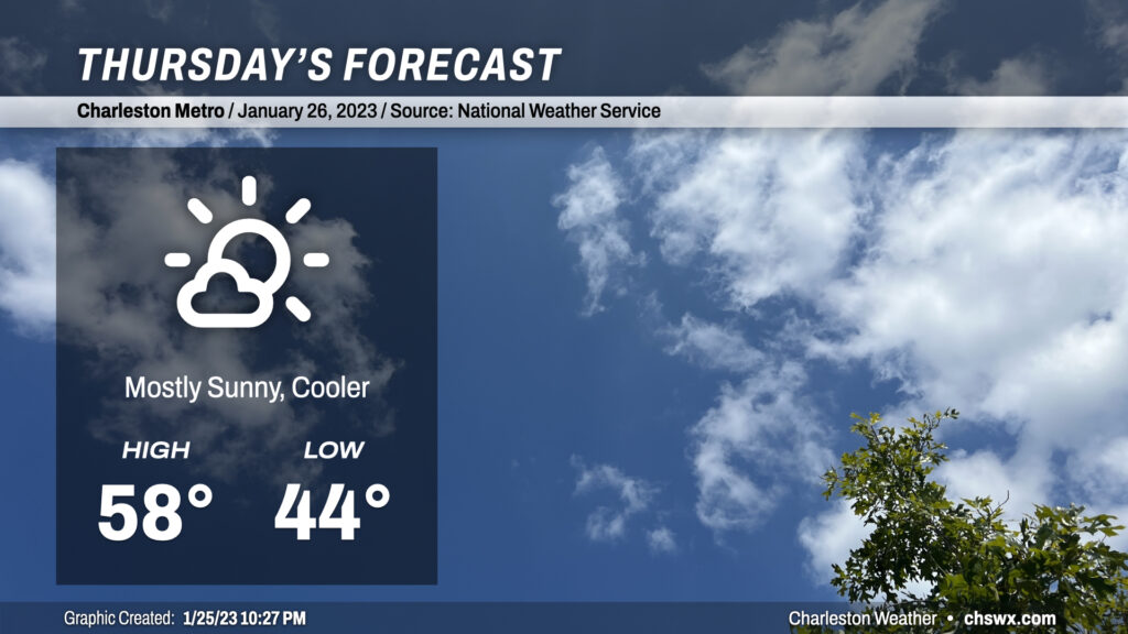
We are back into cooler weather on Thursday in the wake of a cold front which will sweep through the area overnight. We’ll start the day in the mid-40s with a bit of a westerly breeze that’ll stay persistent throughout the day. Clouds will be few and far between, but the ongoing influx of cold air will keep highs pinned into the upper 50s. Overall, though, a rather nice if not slightly-cooler-than-normal January day lies ahead.