Jared Smith founded @chswx on Twitter in 2008 as an experiment in disseminating weather data through social media. In the ensuing decade-and-a-half, @chswx has provided live coverage of tropical cyclones, tornadoes, severe weather, and even a couple bouts of winter weather to the good people of Charleston, SC.
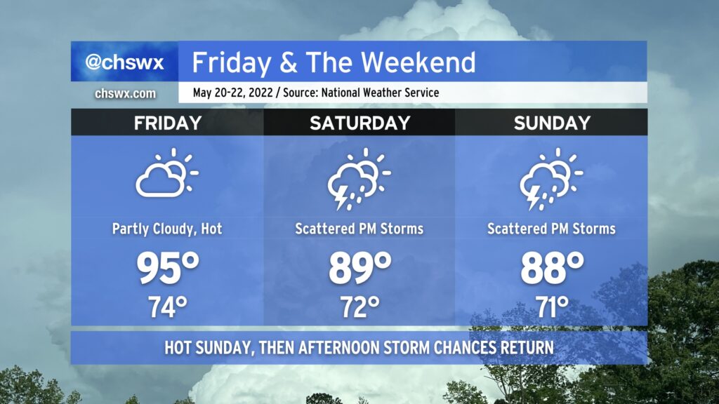
Our run of early summer weather continues into the weekend. While temperatures will be lower than we’ve seen recently — we hit 95° yesterday, and 94° today — we’ll be adding popup showers and thunderstorms back into the mix each afternoon, which is typically the other mode of summer weather we see around these parts.
The drill remains the same: No washout, but conditions could change quickly in the afternoon as thunderstorms develop. Expect storms to develop in the early afternoon around the Highway 17 corridor before moving inland with the seabreeze heading into the late afternoon and evening hours. A storm or two could turn strong to severe with damaging wind gusts and large hail, but an organized, widespread severe weather threat is not on the table here either day. Just be ready to move indoors if thunderstorms approach — remember, lightning makes every thunderstorm dangerous.
I know y’all are thirsty for rain, and this weekend represents a decent chance for many of us to see some much-needed precipitation. Keep in mind, though, that the scattered and cellular nature of these storms will mean that a few people could see quite a bit of rain, while others may not measure much if any. The good news is that we are heading into a more unsettled weather regime getting into next week, so many of us should see at least a little drought relief before the month is over.
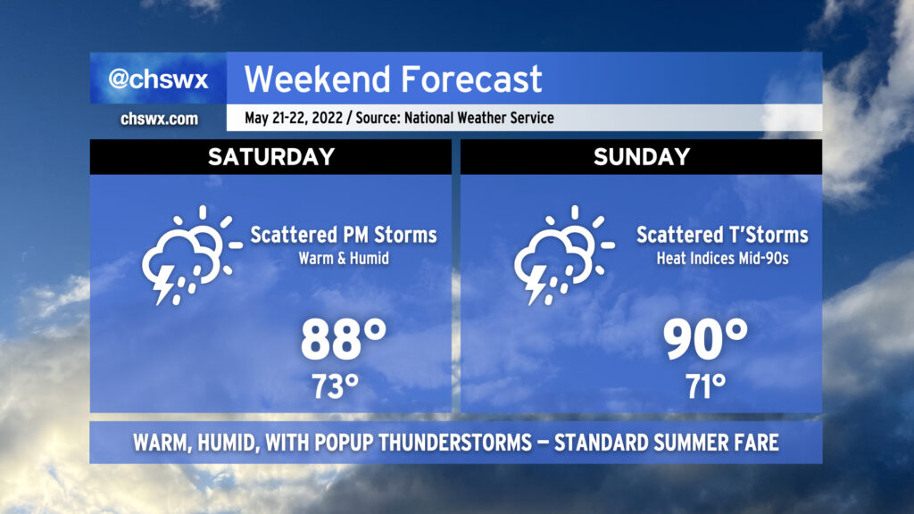
Temperatures will run in the upper 80s to around 90 each afternoon after starting in the low 70s each day, still above normal for this time of year. We look to stay in this temperature regime heading into next week depending on how far south a cold front can get.
We hit 95° at the airport today, making it the warmest day of the year thus far in the Charleston metro area. As of this writing, the cap has held, too, and there are no thunderstorms to speak of. We should repeat this performance tomorrow under partly cloudy skies, with temperatures starting in the mid-70s in the morning to the low-to-mid-90s in the afternoon. Once again, a dearth of energy and a strong cap will keep thunderstorms at bay for Friday, so don’t count on any heat relief in that regard.
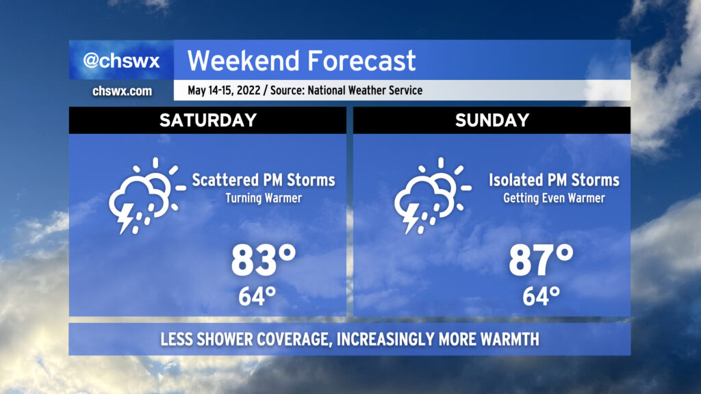
We start to see the high pressure ridge begin to shift away a little on Saturday, though, opening the door for afternoon showers and thunderstorms. They’ll be scattered about, so not everyone will see measurable rain. Where it does rain, though, it could be heavy. Highs top out in the upper 80s to around 90°, tempered by afternoon thunderstorms.
We should see similar weather on Sunday, with even more numerous showers and thunderstorms expected that afternoon. Again, though, some spots may see a downpour while others get little to no measurable precipitation. There also appears to be a risk for a few storms to be on the strong side with strong downburst winds and perhaps hail. Widespread severe weather, at this point, doesn’t appear likely, though.
Scattered showers and thunderstorms remain in the forecast each afternoon thus far next week, so if you miss out on the rain this weekend, there’s still plenty of chances to come.
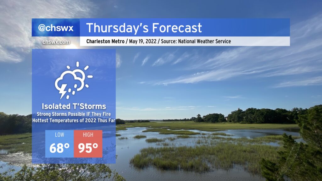
The hottest weather thus far in 2022 looks to arrive on Thursday. We’ll start the day in the upper 60s and warm well into the mid-90s in the afternoon. The record high of 96°, set in 1996, will be challenged under partly cloudy to mostly sunny skies. Heat indices could run close to 100° in the afternoon, so be sure to hydrate and take breaks accordingly.
As a series of mid-level disturbances ripple through the area, there will be a chance for showers and thunderstorms to fire off and move through in the late afternoon and evening hours. IF storms can fire — and this is a big IF — they could be on the strong to severe side. The thermodynamics certainly look good for storms to produce damaging wind gusts and large hail, but it remains to be seen if they can get going thanks to a strong cap on the atmosphere. Gonna be a game of wait, see, and watch the satellite and radar in the meantime.
No mincing words: Here comes the heat. Mostly sunny skies combined with high pressure at the surface and aloft will bring us a period of hot weather to close out the work week.
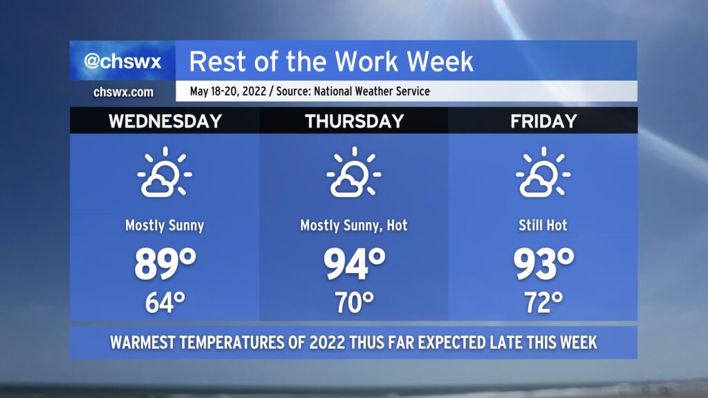
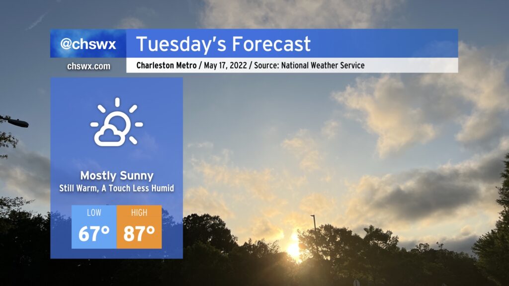
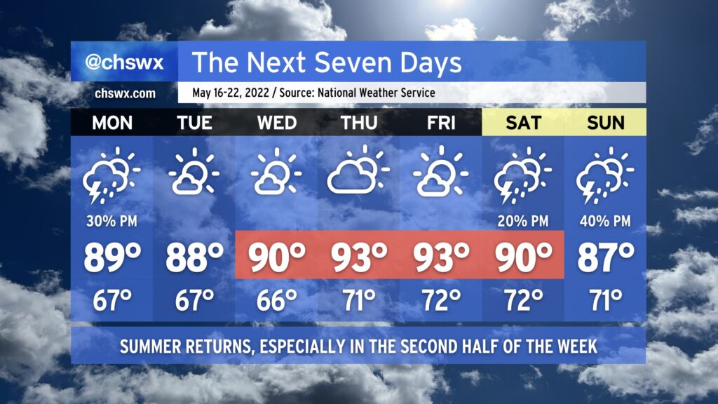
Wednesday will be the last day of the warm-but-not-horribly-humid weather. We’ll start the day in the mid-60s away from the warmer coastline on our way to flirt with 90° once again in the afternoon. The saving grace will be dewpoints in the mid-50s at peak heating, which will help keep heat indices well in check.
Southerly winds, though, will begin to send warm and humid air into the area. Thursday should feature the hottest temperatures thus far this season, with highs in the mid-90s expected away from the coast. Heat indices will run into the upper 90s given the elevated humidity (though certainly not quite as bad as, say, July or August). Mostly sunny skies will persist, so don’t count on cloud cover — much less a thunderstorm — to cool things off briefly.
We should see similar, if not slightly cooler, temperatures for Friday — not that it is much consolation given the NWS forecast highs are topping out in the low 90s still. Skies will once again be mostly sunny and devoid of afternoon thunderstorms.
Shower and storm chances begin to increase Saturday afternoon into next week as the ridge aloft breaks down a bit. We have a few days of scattered storm chances in the offing getting into next week along with cooler temperatures as a cold front moves across the area before stalling, so the good news is that this won’t last forever. For now, though, stay cool and keep on watering in the evenings.
A cold front will sink south of the area very early Tuesday morning, ushering in a slightly cooler and drier airmass for the next couple days before the heat pump really kicks up starting Thursday.
Of course, by “slightly cooler and drier” I mean “it won’t be 90° with a dewpoint in the mid-60s in the afternoon,” so keep that in mind as you set expectations for what Tuesday will feel like. But, indeed, it should feel a little better than Monday did. With a slightly drier airmass, the afternoon cumulus field should be a little bit more scattered, allowing for more sunshine. Highs top out in the mid-to-upper 80s thanks to northeasterly flow developing across the area, coolest at the immediate coast.
The northeasterly winds combined with the recent full moon at perigee should further enhance the risk for tidal flooding with the evening high tide (peaks a little after 10 PM), with another round of moderate flooding likely between 7 and midnight. Be ready for some sporadic road closures once again as a result.
As foretold earlier, we’ll get one more day of comfortable warmth on Wednesday before a warm front lifts north and the heat pump turns on for Thursday and Friday. Expect highs in the mid-90s for the first time this year away from the coast then, with heat indices perhaps creeping into the upper 90s. Summer’s just about here, folks, whether we want it or not!
Summer’s back this week as above-normal temperatures once again take root across the area thanks to high pressure and dry air precluding much in the way of thunderstorm formation for a majority of the week.
Monday afternoon offers the best shot at a shower or thunderstorm — albeit at around a 30% probability — as a cold front approaches the area and stalls out. A storm or two could be on the strong side with damaging wind gusts and large hail possible., but the vast majority of us won’t see severe weather, and a good bit of us may not even see much in the way of rain — unwelcome news for a still-parched Lowcountry.
The aforementioned front stalls out Tuesday and lingers in the area through Wednesday. Drier air, though, is going to keep rain chances squelched for the most part. Once the front lifts back north as a warm front and high pressure builds back from the west Wednesday into Thursday, temperatures will start to respond by heading into the low to even mid-90s in some spots, especially Thursday and Friday. Meanwhile, rain chances are held to a whimper.
High pressure starts to loosen its grip over the weekend, and afternoon thunderstorm chances start to tick up as a result (though isolated to scattered coverage is expected at best). Highs will continue to run above normal in the low 90s on Saturday before moderating slightly back to the upper 80s on Sunday.
For now, though, keep on watering and feel free to get your car washed, because Mother Nature’s going to be of little to no help in that department for at least the next week.
After today’s round of rain for many of us, we return to a drier and warmer pattern once more as low pressure slips out of the area. While isolated to scattered thunderstorms will be possible each afternoon, a good bit of us will remain dry. Highs will begin to head back up starting Saturday, with low-to-mid-80s expected across the area. On Sunday, highs look to peak closer to the upper 80s, and we’ll be flirting with 90° by Monday, as above-normal temperatures are expected heading into much of next week.
Coastal flooding will remain a concern with each high tide cycle through Saturday evening, and then with the evening high tide on Sunday as well. Minor to moderate coastal flooding looks to be probable, with road closures a consideration an hour or two each side of the predicted time of high tide. Expect Coastal Flood Advisories from the National Weather Service.
This weekend’s high tides:
Saturday: 6:55 AM (approaching minor flood), 7:33 PM (minor flood stage)
Sunday: 7:46 AM (currently predicted to stay below flood stage), 8:23 PM (minor to moderate flood)
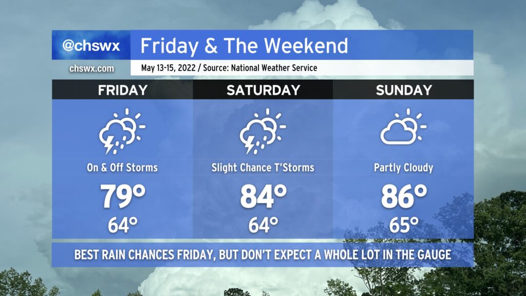
Low pressure, which has brought some generally light showers to the area today, will continue to push southwestward across the area for Friday and the first part of the weekend. The best rain chances arrive tomorrow as the low makes its closest approach, but aside from some pockets of heavier rain, storm totals should generally run around a half-inch to 3/4” at best — certainly not the drought-buster we need. Temperatures will top out a little warmer in the upper 70s to around 80° as winds begin to turn more southerly as the low moves inland.
Scattered showers and a thunderstorm or two will continue to be possible heading into Saturday as the low meanders westward. Southerly flow around the low will continue to keep the heat pump running, though, and highs should top out in the mid-80s in the afternoon after we start in the mid-60s. While a shower or storm can’t be ruled out for Sunday, most should stay dry, and temperatures continue to nudge upward in the afternoon on the higher end of the mid-80s. By next Monday, we should be in the 90s again, so soak up the last of this cool air while you can!
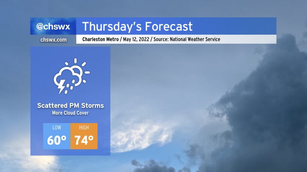
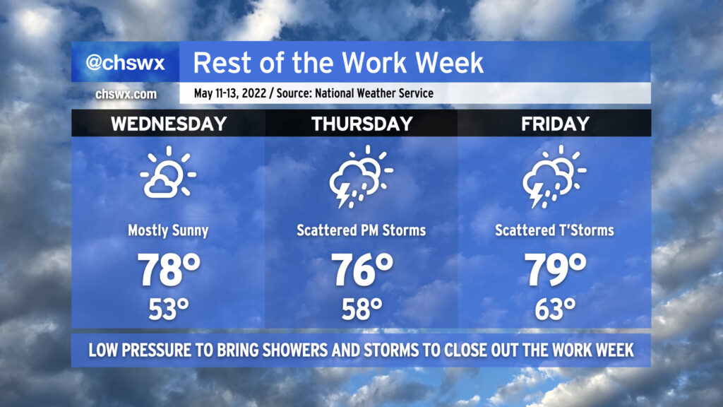
After a rather gorgeous — if not a touch windy — stretch of weather across the Lowcountry, rain chances return to the forecast for Thursday afternoon and evening as coastal low pressure drifts closer to the area. We’ll start to see an increase in cloud cover overnight into tomorrow morning, but the best rain chances should hold off until the afternoon. We may be contending with some showers for the evening drive, so be alert to that possibility. Temperatures will still run on the cool side as breezy north and northeast winds continue across the area; with the cloud cover and approaching rainfall, we shouldn’t see highs much warmer than the mid-70s.
We’ve got one more really good weather day in store for Wednesday before low pressure drifts westward toward the coast, bringing in periods of showers and thunderstorms beginning Thursday afternoon and evening into Friday, leaving some scattered shower activity around for Saturday as well. We could definitely use the rain, and it doesn’t look like there will be any severe weather coming along for the ride, either — a win-win situation considering our worsening drought situation. (We could still see a few thunderstorms, though, and lightning makes every thunderstorm dangerous.)
Temperatures will remain below normal through Friday given continued northward winds and then rain-cooled air, especially as we get into Friday. Peeking ahead toward the weekend, though, we will begin to see temperatures rebound into the mid-to-upper 80s as winds go more southerly, with the 90s returning to the picture on Monday. Savor the cooler weather while we’ve got it, because we’ve got fewer and fewer days like this ahead until the fall.