Jared Smith founded @chswx on Twitter in 2008 as an experiment in disseminating weather data through social media. In the ensuing decade-and-a-half, @chswx has provided live coverage of tropical cyclones, tornadoes, severe weather, and even a couple bouts of winter weather to the good people of Charleston, SC.
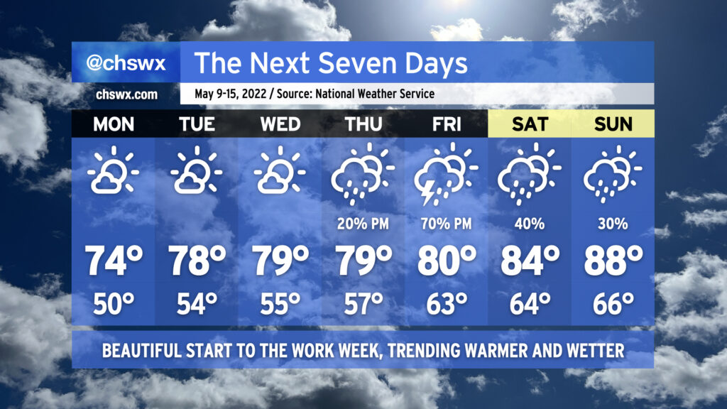
After a highly unseasonably cool Mother’s Day, temperatures will remain generally pleasant over the next few days as high pressure runs the show. We’ll see a gradual warming trend into mid-week, with highs topping out near 80° by Wednesday. Lows, though, will continue to run well below normal in the low to mid-50s away from the coastline into Thursday. Skies should be more clear than we saw for much of today, too — keep the sunscreen applied if you’re out and about!
On Thursday, shower chances will begin to increase in the afternoon as moisture from an offshore low pressure system begins to kick up some as said low moves more westward. The best chance of rain will arrive Friday as the low moves across the area, with the potential for a few heavy downpours in there as well. (Fingers crossed, given the current drought situation!) Shower chances linger into the weekend as above-normal temperatures return. Sunday could once again approach 90° in some locations — ’tis the season.
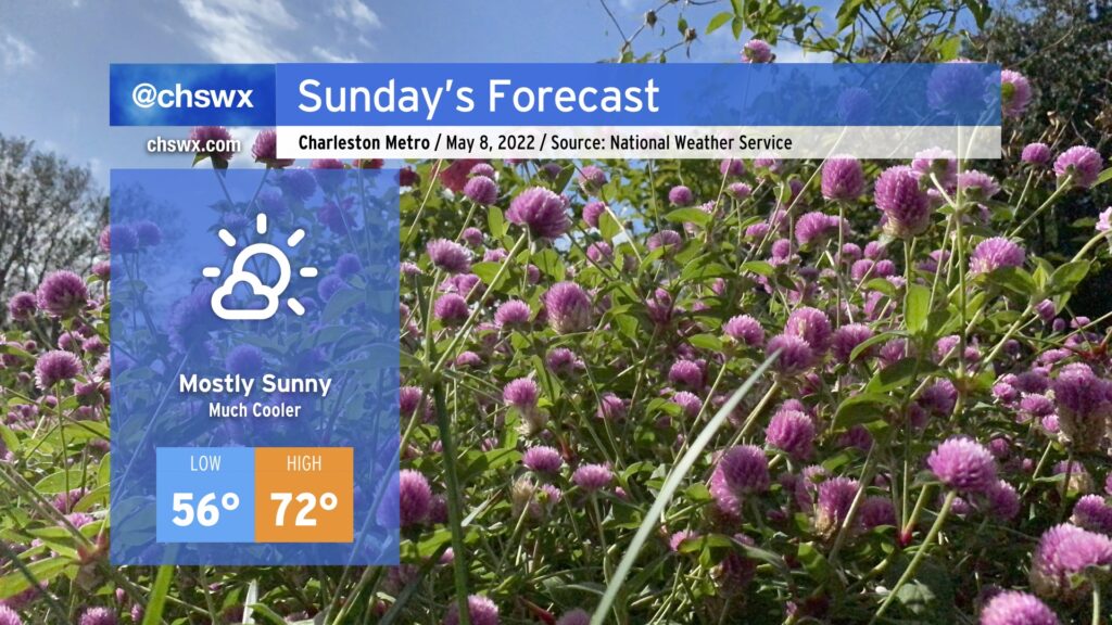
Mother’s Day in the Lowcountry looks pretty outstanding, weather-wise, if not a touch chilly for this point in the year. A reinforcing cold front will come through overnight, helping to drop tomorrow morning’s lows to the mid-50s. Highs will only reach the low 70s despite mostly sunny skies as a trough lingers aloft. This is well below normal for this time of year — the normal high for May 8 is 82°!
We’ll continue this run of below-normal temperatures for a couple more days. Lows could bottom out in the upper 40s in spots on Monday morning before a warming trend begins. Even still, expect temperatures to run right at or just a touch below normal for much of next week. We have all summer to head back into the 90s each day, after all, so let’s get some more spring in while we still can.
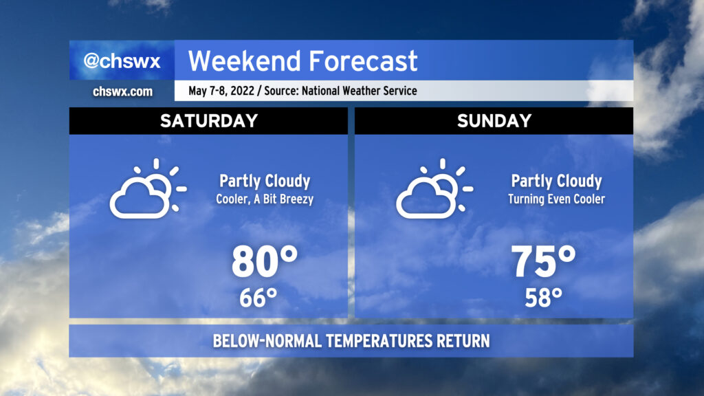
A series of cold fronts will usher in a fairly refreshing airmass after our first 90° days of the year this past week. The first front gets through early tomorrow morning, helping to limit highs to around 80° Saturday afternoon under partly cloudy skies. Winds will be breezy, though, with gusts 30+ MPH possible at times, so be aware if you have outdoor plans or need to drive on the bridges.
A second front comes through overnight Saturday, which will make Sunday even cooler. We’ll start in the 50s and only get to the mid-70s in the afternoon with partly cloudy skies continuing. This is several degrees below normal for this point in May. We’ll keep below-normal temperatures well into next week, too.
One thing we won’t see? Rain. We could certainly use it, too, as moderate drought continues across the area. Our next rain chance arrives next Thursday, so keep watering until then.
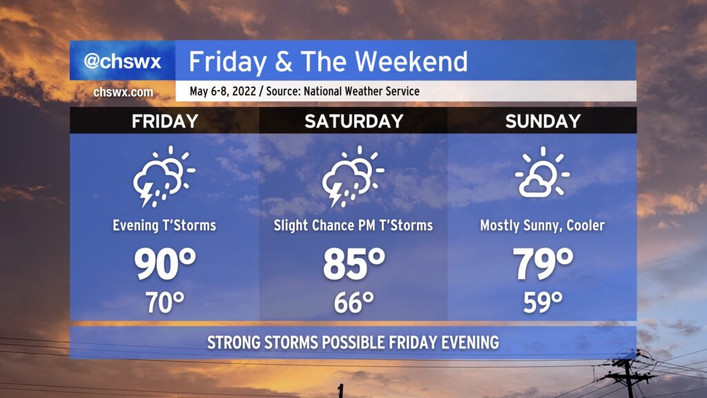
A cold front will come through this weekend, bringing strong storms to the area Friday evening before restoring order to temperatures by Sunday.
After hitting 92° at the airport today, we’ll climb back into the 90s on Friday afternoon. Much of Friday looks to remain dry (though a stray shower or two can’t be ruled out in the morning). However, we’ll be watching a squall line and an associated risk for severe weather push eastward through the Carolinas during the day. Damaging winds and large hail would be the primary concerns, though a tornado can’t be ruled out. The best risk of severe weather will be along and west of I-95. The line will be getting into the Charleston metro area later in the evening, and as a result, we should begin to see some weakening as daytime heating is lost. However, sporadic wind damage or hail will still be possible as the line pushes offshore, so you’ll want to keep an eye out for rapidly changing conditions Friday night.
The cold front will get through the area Saturday morning, but a deep trough aloft will still allow for a slight chance of showers and thunderstorms in the afternoon. Temperatures will top out in the mid-80s, a far cry from where we’ve landed the last couple days.
Pleasant weather returns in full force for Sunday. High pressure will build in, and the cooler and drier airmass will yield highs in the upper 70s to around 80° under mostly sunny skies. If there’s a pick day for getting out and about this weekend, it’s Sunday.
From there, seasonable temperatures continue for much of the new work week, with highs in the upper 70s to low 80s continuing at least into mid-week, with dry weather looking to stay in place until Thursday. But let’s not trouble ourselves too much with a new work week with a weekend on tap, shall we?
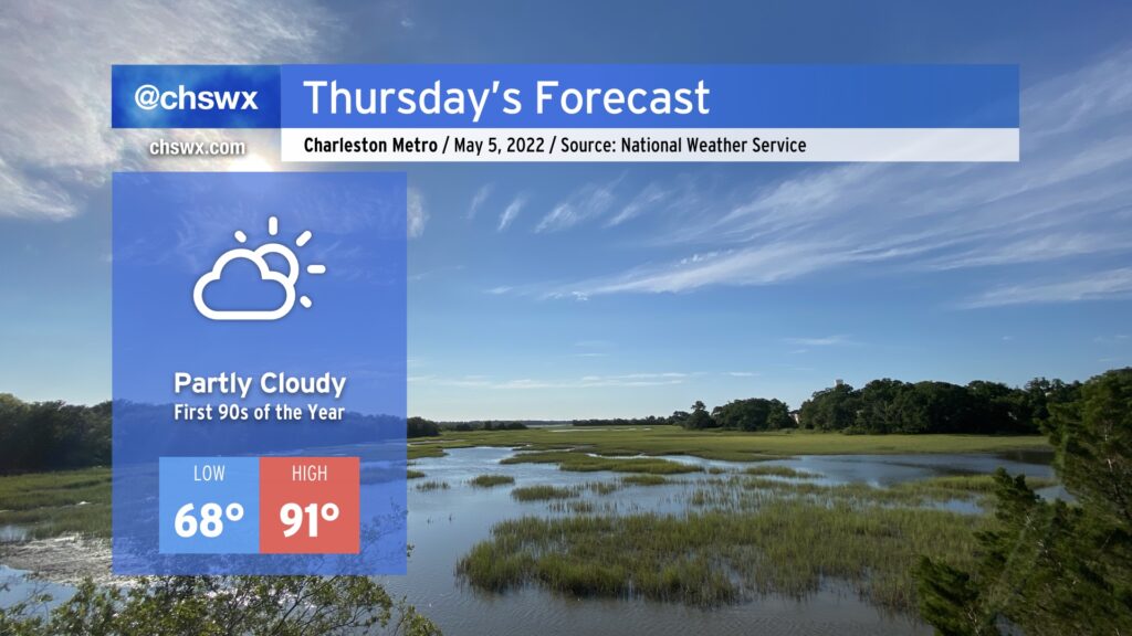
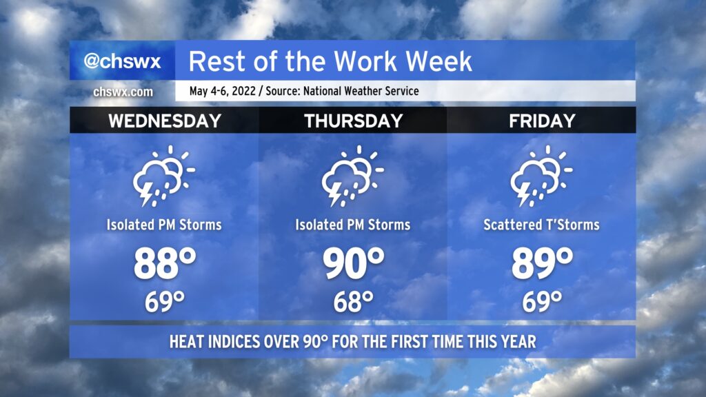
Thursday looks to be the hottest day of 2022 thus far, with highs in the low 90s expected away from the coast. (It’ll be in the low to mid-80s at the beaches, making for a good getaway if you can get away with it.) Despite a cold front stalled nearby, expect a little too much dry air aloft to get much in the way of thunderstorm formation in the afternoon (though you can never totally, 100% rule out a stray storm in this kind of regime).
We stay hot heading into Friday, with another day touching 90° anticipated. We should see some more thunderstorms, though, especially as the front begins to work into the area in the afternoon and overnight into Saturday. The front will kick the summer-like weather out for a few days at least starting Sunday, with highs around 80° making for what looks to be quite a nice weather day to round out the weekend!
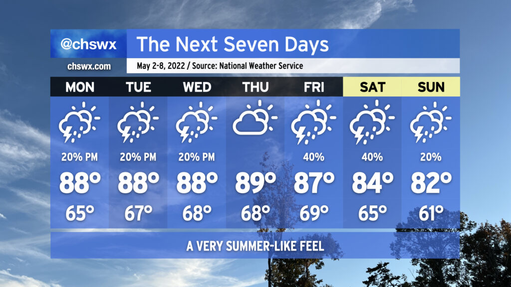
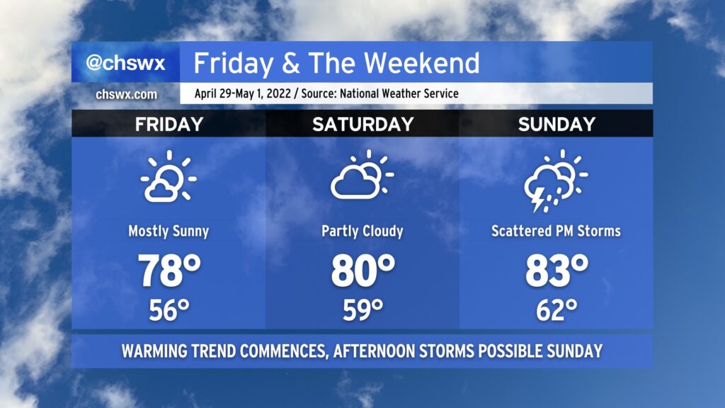
Our warm start to May continues for the rest of the work week as Atlantic high pressure and ridging aloft build across the area. We should see our first 90° reading of the year on Thursday. This comes a few weeks earlier than we saw 90° for the first time last year, but overall, we touch 90° in the first week of May more often than not. We stay warm on Friday as a cold front approaches from the west, perhaps getting close to 90° once again.
Isolated showers and thunderstorms will factor into the forecast each afternoon along and ahead of the seabreeze, with a pulse severe thunderstorm or two possible with damaging downburst winds and perhaps some large hail. Widespread severe weather is not expected, and I suspect that the best chances for a severe storm will be found where outflow boundaries and/or the seabreeze intersect, giving a little more oomph to thunderstorm updrafts.
We should see an uptick in shower and storm coverage on Friday afternoon and evening as a cold front gets a little closer; however, these storms will remain generally scattered. Keep an eye out for storms Friday evening and be ready to bring outdoor activities indoors quickly if lightning approaches. If you’re hearing thunder or seeing lightning strikes, you’re close enough to be struck!
The front will get into the area on Saturday with more scattered showers and thunderstorms. Cooler and drier air moves in Sunday, gradually scouring out precipitation and cloud cover while bringing temperatures back down closer to early May normals (low 80s).
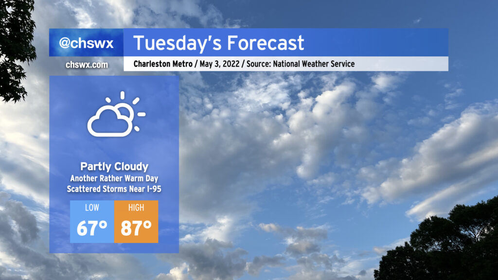
After Monday became the warmest day so far in 2022 with a high of 87°, Tuesday should come right back and at least match that with another round of warm and muggy weather. We’ll start the day in the mid-to-upper 60s away from the coast. (I wouldn’t be surprised to see temperatures not get below 70° in some spots at the beaches.) Temperatures will warm to the mid-80s under partly cloudy skies ahead of the seabreeze.
With high pressure still in play across the Lowcountry, afternoon shower and storm chances in the Charleston metro should stay at a minimum, but won’t be zero (as Daniel Island found out today with an absolute gullywasher). There will be a better chance of rain along and inland of I-95 where storms will have an easier time getting going thanks to surface temperatures approaching 90°. These storms should fall apart, though, as they move eastward toward the coast in the evening as sinking and cooler air behind the seabreeze circulation will help tamp out convection.
We continue to get warmer as the week goes on, with Thursday looking quite probably like our first 90° day of the year. A cold front could make Friday and the weekend a little unsettled, but will also restore some order to temperatures, bringing them back to early May norms by the end of the weekend.
The first week of May will serve as a preview of what’s to come as we edge closer and closer to summertime. The mornings will become increasingly muggy with lows bottoming out in the mid-60s on Monday and getting warmer as the week goes on. Highs for much of the week will run in the upper 80s; dewpoints in the upper 60s will make the afternoons feel more like the low 90s. We’ll even see that standard afternoon slight chance of thunderstorms that we know and love in the warm season Monday-Wednesday.
As we head into Friday and the weekend, a storm system will push a stalled cold front into and eventually through the area, elevating our chance of scattered showers and thunderstorms for Friday and Saturday. By Sunday, expect the front to be through, cooling us off a little with highs in the low 80s expected, making for what should be a nice Mother’s Day with just a slight chance of a shower or storm in the afternoon.
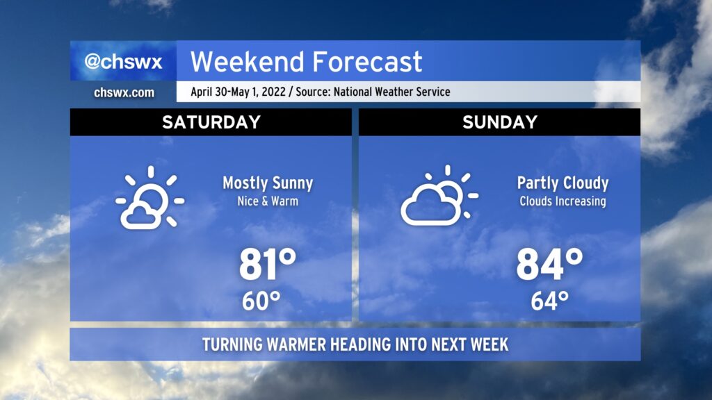
We’ve got another pretty good-looking weekend coming up. It won’t be quite as clear or as dry as last weekend, but it’ll still more than get the job done as temperatures rise through the 80s throughout the weekend. If sunshine’s your thing, suspect Saturday is going to be a little more in your favor as deep-layered high pressure hangs on for one more day, keeping cloud cover to just some scattered fair weather cumulus ahead of the seabreeze in the afternoon.
We’ll start to see high pressure aloft move out of our area a little bit more on Sunday. This should increase cloud coverage and could even introduce an afternoon shower or storm particularly inland. However, most of us will stay dry as highs head into the mid-80s in the afternoon. Outdoor activities are still go — just remember, when thunder roars, go indoors!
Looking ahead to next week, we see some of the warmest weather thus far this year in store particularly as we get into midweek and beyond. Periodic shower and thunderstorm chances will factor into the forecast, especially later in the week as a front gets nearby. But for now, enjoy the weekend as we flip the calendar to May! (Already!)
Generally good weather continues as we head into Friday and the weekend. We’ll see high pressure begin to slip offshore, allowing a little more warm and moist air to move into the area as the weekend goes on. This will allow temperatures to reach the low 80s on Saturday and run even warmer on Sunday.
With the influx of moisture and some upper-level energy coming through on Sunday, expect a scattering of showers and thunderstorms particularly in the afternoon. Definitely no washout here, just make sure you’ve got a backup plan for any outdoor activities. Remember: When thunder roars, go indoors!
The warming trend will continue well into next week, with some of the warmest temperatures so far in 2022 expected by mid-week. (But let’s enjoy the weekend first before we dive into another work week!)